- My Forums
- Tiger Rant
- LSU Recruiting
- SEC Rant
- Saints Talk
- Pelicans Talk
- More Sports Board
- Winter Olympics
- Fantasy Sports
- Golf Board
- Soccer Board
- O-T Lounge
- Tech Board
- Home/Garden Board
- Outdoor Board
- Health/Fitness Board
- Movie/TV Board
- Book Board
- Music Board
- Political Talk
- Money Talk
- Fark Board
- Gaming Board
- Travel Board
- Food/Drink Board
- Ticket Exchange
- TD Help Board
Customize My Forums- View All Forums
- Show Left Links
- Topic Sort Options
- Trending Topics
- Recent Topics
- Active Topics
Started By
Message

 2
2


Posted on 6/21/17 at 9:13 am to rds dc
Tornado was just spotted in my neighborhood in Biloxi

Posted on 6/21/17 at 9:16 am to vistajay
West shore of Lake Pontchartrain is pretty high. Water is over the marsh near Spillway on I10 and it's pushing in to the canals and backing up in Laplace.
It's nothing we haven't seen before but it's a little unnerving tbh. Hoping the wind keeps laying down and stop pushing more water in there.
It's nothing we haven't seen before but it's a little unnerving tbh. Hoping the wind keeps laying down and stop pushing more water in there.
Posted on 6/21/17 at 9:21 am to tgrgrd00
Chances of my flight landing in New Orleans for 7pm tonight?
Not very likely I assume?
Not very likely I assume?

Posted on 6/21/17 at 9:22 am to Lazy But Talented
Wrong
Very likely
Very likely
Posted on 6/21/17 at 9:26 am to CorkSoaker
several tornado warnings on ms gulf coast right now
Posted on 6/21/17 at 9:27 am to rds dc
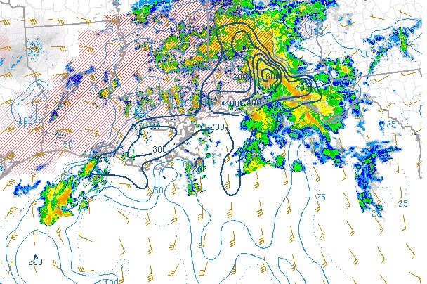
A few things of interest this morning:
- notice low clouds curving as they race out of the Caribbean and Bahamas and the flow around the southern portion of Cindy is resulting in enhanced convergence in the E. Gulf resulting in ongoing convection
- some clearing skies in SE LA, that may allow for an increase of surface based instability possibly increasing the tornado threat
- increasing convection on the NW side of Cindy, it that can maintain then the heavy rain threat increases in SW LA and SE TX
Posted on 6/21/17 at 9:30 am to Lazy But Talented
You're not going to the game tonight?
Posted on 6/21/17 at 9:33 am to Mr. Hangover
Nope. Planned to catch two games then head back.
Posted on 6/21/17 at 9:47 am to Lazy But Talented
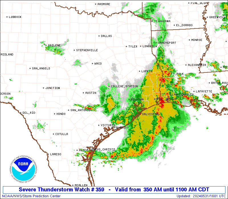
Where can I find rain totals along panhandle?

Posted on 6/21/17 at 9:47 am to Roll Tide Ravens
Inland forecast track keeps trending SE, and the center could cross over NW Alabama. This could set up a decent threat of tornadoes (weaker, short-lived ones) over parts of Alabama.

And accordingly, we have a slight risk for Friday:

And accordingly, we have a slight risk for Friday:
Posted on 6/21/17 at 9:49 am to rds dc
Pretty sure it's actually heading more west-northwest instead of northwest. It's moving much more westward than northwestward to me.
Posted on 6/21/17 at 10:05 am to Lazy But Talented
Chances of my flight taking off from New Orleans tomorrow at 11 am?
Pretty good I suppose?
Pretty good I suppose?

Posted on 6/21/17 at 10:06 am to poops_at_parties
Tornado watch for JP through 7pm just popped up on my phone.
Posted on 6/21/17 at 10:09 am to ST.TAMMANYTIGER
100 percent

Posted on 6/21/17 at 10:10 am to rds dc
idk what im looking at on the precip radar, but what im seeing, looks like I'm safe in st. landry. We havent had a raindrop and I think we missed it entirely.

Posted on 6/21/17 at 10:14 am to rds dc
So, this beehotch is getting stronger?
Posted on 6/21/17 at 10:16 am to musick
Tropical storm warnings for the AL and MS Gulf Coasts and for parts of LA near New Orleans have been discontinued. Winds are at 50 mph. Movement to the WNW at 10mph.
New Forecast track from 10am CDT advisory:

New Forecast track from 10am CDT advisory:
This post was edited on 6/21/17 at 10:19 am
Posted on 6/21/17 at 10:17 am to musick
Latest advisory -
The Tropical Storm Warning is discontinued north and east of the mouth of the Mississippi River, including Metropolitan New Orleans and Lake Pontchartrain.
Winds have dropped to 50 MPH with more weakening expected.
The Tropical Storm Warning is discontinued north and east of the mouth of the Mississippi River, including Metropolitan New Orleans and Lake Pontchartrain.
Winds have dropped to 50 MPH with more weakening expected.

 Page 89 of 105

Popular
Back to top