- My Forums
- Tiger Rant
- LSU Recruiting
- SEC Rant
- Saints Talk
- Pelicans Talk
- More Sports Board
- Winter Olympics
- Fantasy Sports
- Golf Board
- Soccer Board
- O-T Lounge
- Tech Board
- Home/Garden Board
- Outdoor Board
- Health/Fitness Board
- Movie/TV Board
- Book Board
- Music Board
- Political Talk
- Money Talk
- Fark Board
- Gaming Board
- Travel Board
- Food/Drink Board
- Ticket Exchange
- TD Help Board
Customize My Forums- View All Forums
- Show Left Links
- Topic Sort Options
- Trending Topics
- Recent Topics
- Active Topics
Started By
Message

Severe Weather Thread (Thursday, April 25th)
Posted on 4/23/19 at 10:14 am
Posted on 4/23/19 at 10:14 am

quote:
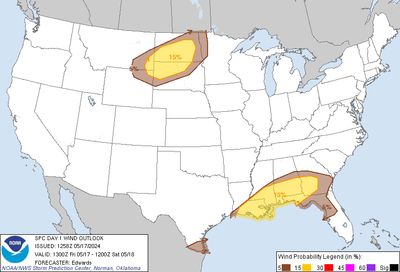
SPC AC 251243 Day 1 Convective Outlook NWS Storm Prediction Center Norman OK 0743 AM CDT Thu Apr 25 2019 Valid 251300Z - 261200Z ...THERE IS A SLIGHT RISK OF SEVERE THUNDERSTORMS ACROSS THE MIDDLE GULF COAST STATES... ...SUMMARY... Severe thunderstorms associated with a wind damage and tornado risk are expected across the central Gulf Coast region through this evening. ...Synopsis... A southern-stream upper low centered over southeast Oklahoma and the ArkLaTex early today will reach the southern Appalachians vicinity tonight. Preceding this upper low/trough, a belt of relatively strong southwesterly winds aloft (50+ kt at 500mb) will overspread the middle Gulf Coast States today and reach the coastal Southeast tonight. A strong-to-severe northeast/southwest-oriented wavy MCS with embedded bows is ongoing early this morning from central Mississippi to coastal south-central Louisiana. The northern extent of this convective line and its related outflow/cloud debris will effectively delineate the northern extent of the severe risk. This will be as moderate moistening otherwise occurs, with diurnal destabilization focused across southern/eastern Louisiana and southern Mississippi into southern Alabama/Florida Panhandle, although considerable cloud debris and squall-line preceding convection spreading inland across coastal Louisiana may hinder the overall degree of destabilization and overall magnitude of today's severe risk. Even if overall instability remains modest, strongly sheared profiles will support organized storms. While a few line-preceding semi-discrete supercellular storms may occur, a broken convective line should be prevalent with a common Line-Echo Wave Pattern configuration. Damaging winds can be expected. Some strengthening of shear/SRH within the lowest few km will also support the possibility of a few tornadoes. A severe risk may develop as far east as the Florida Panhandle by late afternoon/early evening.


quote:
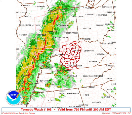
URGENT - IMMEDIATE BROADCAST REQUESTED Tornado Watch Number 102 NWS Storm Prediction Center Norman OK 810 AM CDT Thu Apr 25 2019 The NWS Storm Prediction Center has issued a * Tornado Watch for portions of Southern and Eastern Louisiana Southern Mississippi Coastal Waters * Effective this Thursday morning and afternoon from 810 AM until 300 PM CDT. * Primary threats include... A couple tornadoes possible Scattered damaging wind gusts to 70 mph possible SUMMARY...Bands of mostly linearly organized storms are expected to gradually intensify across the region through the late morning and afternoon hours. Strong shear and moderate moisture will support a risk of severe thunderstorms capable of damaging winds and some tornadoes. The tornado watch area is approximately along and 85 statute miles east and west of a line from 60 miles north northwest of Pine Belt MS to 40 miles west southwest of Houma LA. For a complete depiction of the watch see the associated watch outline update (WOUS64 KWNS WOU2). PRECAUTIONARY/PREPAREDNESS ACTIONS... REMEMBER...A Tornado Watch means conditions are favorable for tornadoes and severe thunderstorms in and close to the watch area. Persons in these areas should be on the lookout for threatening weather conditions and listen for later statements and possible warnings.
LIX:
quote:
.SHORT TERM... A cold front will move into the area today bringing a line of strong thundestorms with it. A few cells ahead of the line will be possible as well. The main issues with any severity will be damaging winds and tornadic activity. The line will slow as it reaches the area which sets up a prolonged period of heavy rainfall mainly over the northern half of the area. Total rainfall amounts should be in the 1 to 3 inch range with isolated higher amounts. There is the potential for these amounts to fall within a short time frame. If this occurs, then flooding of low lying and poor drainage areas could occur. Once the front moves through, which should be by early evening, clouds and some light rain areas will remain but conditions will gradually improve through tonight. Models are keeping all mention of clouds and light rain to the east associated with an 850mb thermal trough for Friday morning. This may be the case, but it will be just off to the east and still may affect a few of the Miss coastal counties. Regardless, all the area will begin to dry out Friday through the extended portion of this fcast.
This post was edited on 4/25/19 at 8:24 am
 39
39

Posted on 4/23/19 at 10:15 am to DVinBR
City showed up to clean out my ditches this morning.
Bring it on mother nature
Bring it on mother nature
Posted on 4/23/19 at 10:15 am to DVinBR
First page

Posted on 4/23/19 at 10:15 am to DVinBR
Are we shutting down the city this week?

Posted on 4/23/19 at 10:16 am to DVinBR
TWO PERCENT APOCALYPSE!!!

Posted on 4/23/19 at 10:16 am to DVinBR
Oh, Lawd. Weather. Not scared. But might go on a beer run. Just in case. 

Posted on 4/23/19 at 10:16 am to DVinBR

Why does God hate SE Louisiana?
Maybe I'll get another day off of work....
Posted on 4/23/19 at 10:16 am to DVinBR
First Paige
Posted on 4/23/19 at 10:16 am to DVinBR
Shut it all down again for a thunderstorm!
Posted on 4/23/19 at 10:16 am to tgrbaitn08

Posted on 4/23/19 at 10:17 am to DVinBR
I hope the ladies in our office don't see this. They cried last Thursday about leaving early since they thought they were going to die if they stayed at work. Owners let them leave. Embarrassing.

Posted on 4/23/19 at 10:17 am to DVinBR
So we're starting pre-"slight risk of severe thunderstorm" threads now?
Posted on 4/23/19 at 10:17 am to Rize
quote:We have to!
Are we shutting down the city this week?
Rain is scary and lightning is double scary!
Posted on 4/23/19 at 10:18 am to Scruffy
quote:
Rain is scary and lightning is double scary!
Thunder makes me poop my pants

Posted on 4/23/19 at 10:18 am to DVinBR
Driving from Bawcomville to Punta Cana Thursday, when should I leave?
Posted on 4/23/19 at 10:18 am to DVinBR
Remember, even though it's a slight risk, the storm system that put down the EF3 wedge in Michoud was started out as a slight risk
eta: it was later upgraded to enhanced after they saw the development
eta: it was later upgraded to enhanced after they saw the development
This post was edited on 4/23/19 at 10:22 am
Posted on 4/23/19 at 10:19 am to DVinBR
Please stop this stupid shite.
Posted on 4/23/19 at 10:19 am to DVinBR
Schools will cancel for real.

 Page 1 of 20

Popular
Back to top