- My Forums
- Tiger Rant
- LSU Recruiting
- SEC Rant
- Saints Talk
- Pelicans Talk
- More Sports Board
- Winter Olympics
- Fantasy Sports
- Golf Board
- Soccer Board
- O-T Lounge
- Tech Board
- Home/Garden Board
- Outdoor Board
- Health/Fitness Board
- Movie/TV Board
- Book Board
- Music Board
- Political Talk
- Money Talk
- Fark Board
- Gaming Board
- Travel Board
- Food/Drink Board
- Ticket Exchange
- TD Help Board
Customize My Forums- View All Forums
- Show Left Links
- Topic Sort Options
- Trending Topics
- Recent Topics
- Active Topics
Started By
Message
re: Hurricane Florence - Catastrophic Flooding Potential
Posted on 9/2/18 at 10:17 am to NorthEndZone
Posted on 9/2/18 at 10:17 am to NorthEndZone
It wouldn’t be the LSU home opener week without a disturbance in the gulf.
 1
1

Posted on 9/2/18 at 10:23 am to East Coast Band


Posted on 9/2/18 at 10:23 am to Fight4LSU
quote:
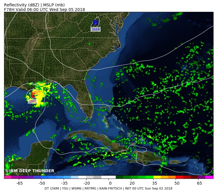
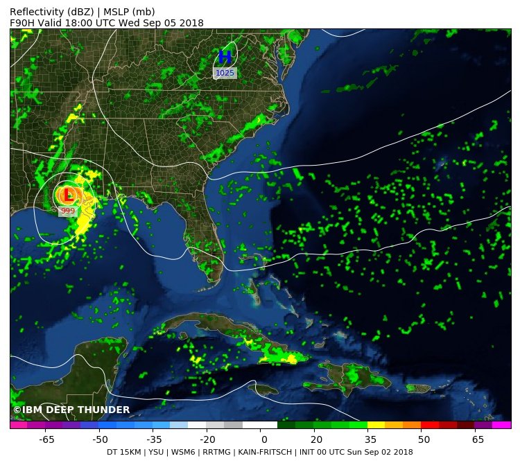
@MJVentrice
Our Deep Thunder model (from IBM) is indicating (amongst other models) a weak Tropical Storm to impact the New Orleans + vicinity area later this week. Note this model continues to develop this storm over land, which suggests the "Brown Ocean" phenomena.
This post was edited on 9/2/18 at 10:24 am
Posted on 9/2/18 at 10:28 am to GEAUXmedic
Wtf is the brown ocean phenomenon
Posted on 9/2/18 at 10:29 am to GEAUXmedic
quote:
which suggests the "Brown Ocean" phenomena.
sounds like something you'd talk to your doctor about after visiting the bathroom
Posted on 9/2/18 at 10:29 am to TthomasJR
Basically there's so much water instead of land, it could possibly allow the storm to strengthen when it hits "land"
Posted on 9/2/18 at 10:30 am to TthomasJR
quote:
Wtf is the brown ocean phenomenon
Wiki
quote:
The brown ocean effect is an observed weather phenomenon involving tropical cyclones after landfall. They are commonly expected to lose energy when they make landfall, but instead maintain strength or intensify over land surfaces.[1] While these systems are highly common in the United States and China, the National Oceanic and Atmospheric Administration (NOAA) names Australia the most conducive environment after 30 years of research. In Australia, such storm systems are called agukabams
Posted on 9/2/18 at 10:31 am to TheriotAF
quote:
Basically there's so much water instead of land, it could possibly allow the storm to strengthen when it hits "land"
and south Louisiana has been getting a shite ton of rain over the last week or so

Posted on 9/2/18 at 10:32 am to rt3
Well, that would suck.

Posted on 9/2/18 at 10:39 am to rds dc
AL91?
what happened to invest?
what happened to invest?
Posted on 9/2/18 at 10:41 am to rt3
quote:
AL91?
what happened to invest?
Same thing, AL91 is just another way it's named.
Posted on 9/2/18 at 10:58 am to rds dc
I'm sorry but I'm really skeptical of this. I think it's going to form earlier than that depending on how fast it moves. I'll bet it turns into something tomorrow. Looking at radar today even with the heavy shear you can definitely tell it looks like the thing is trying to organize itself. I'm hoping it does take until at least Tuesday then hits land Wednesday.
Good news here to note is the Euro has it weaker than yesterday which was running into a lot more bad scenarios. Also, looking at it past land it might be a real problem for Texas with flooding. Those poor souls...
Good news here to note is the Euro has it weaker than yesterday which was running into a lot more bad scenarios. Also, looking at it past land it might be a real problem for Texas with flooding. Those poor souls...
Posted on 9/2/18 at 11:19 am to deuce985
It's still a wave. Not even a closed circulation.
This post was edited on 9/2/18 at 11:21 am

Posted on 9/2/18 at 11:22 am to deuce985
I see models moving it through pretty fast. Seems like most areas get 6” or so over a 72 hour period. No biggie.
Posted on 9/2/18 at 11:27 am to deuce985
quote:
I'm sorry but I'm really skeptical of this. I think it's going to form earlier than that depending on how fast it moves. I'll bet it turns into something tomorrow. Looking at radar today even with the heavy shear you can definitely tell it looks like the thing is trying to organize itself. I'm hoping it does take until at least Tuesday then hits land Wednesday.
I saw that early this morning. It looked as if there is some surface circulation going on.
Posted on 9/2/18 at 11:35 am to deuce985
I see the doom and gloom wishcasters are up today
Posted on 9/2/18 at 11:38 am to Cosmo
Since there is no work tomorrow we can play the monitor and prepare drinking game to make all the upcoming press conferences more fun.
Posted on 9/2/18 at 11:38 am to Cosmo
quote:
I see the doom and gloom wishcasters are up today
Yeah, they're already gassed up, and stocked up cans of Vienna sausage..
This post was edited on 9/2/18 at 11:40 am
Posted on 9/2/18 at 11:41 am to rds dc
Recon flight plan is out for tomorrow starting just south of the Keys and ending far west of Tampa in the E Gulf
716
NOUS42 KNHC 021630
REPRPD
WEATHER RECONNAISSANCE FLIGHTS
CARCAH, NATIONAL HURRICANE CENTER, MIAMI, FL.
1230 PM EDT SUN 02 SEPTEMBER 2018
SUBJECT: TROPICAL CYCLONE PLAN OF THE DAY (TCPOD)
VALID 03/1100Z TO 04/1100Z SEPTEMBER 2018
TCPOD NUMBER.....18-101
I. ATLANTIC REQUIREMENTS
1. SUSPECT AREA (APPROACHING SE GULF OF MEXICO)
FLIGHT ONE - TEAL 71 FLIGHT TWO - NOAA 42
A. 03/1500Z A. 03/2200Z
B. AFXXX 01AAA INVEST B. NOAA2 0207A CYCLONE
C. 03/1230Z C. 03/2030Z
D. 24.7N 80.7W D. 25.6N 82.1W
E. 03/1430Z TO 03/1900Z E. 03/2130Z TO 04/0130Z
F. SFC TO 10,000 FT F. SFC TO 15,000 FT
FLIGHT THREE - TEAL 72 FLIGHT FOUR - NOAA 42
A. 03/2330Z,04/0530Z A. 04/1000Z
B. AFXXX 0307A CYCLONE B. NOAA2 0407A CYCLONE
C. 03/2130Z C. 04/0830Z
D. 25.8N 82.5W D. 27.1N 84.8W
E. 03/2300Z TO 04/0530Z E. 04/0930Z TO 04/1330Z
F. SFC TO 15,000 FT F. SFC TO 15,000 FT
FLIGHT FIVE - TEAL 73
A. 04/1130Z,1730Z
B. AFXXX 0507A CYCLONE
C. 04/1000Z
D. 27.3N 85.3W
E. 04/1100Z TO 04/1730Z
F. SFC TO 15,000 FT
2. OUTLOOK FOR SUCCEEDING DAY:
A. CONTINUE 6-HRLY FIXES IF SYSTEM DEVELOPS AND REMAINS
A THREAT.
B. ANOTHER POSSIBLE NOAA 42 P-3 TAIL DOPPLER RADAR MISSION
IN SUSPECT AREA DEPARTING KLAL AT 04/2030Z.

 Page 16 of 400

Popular
Back to top