- My Forums
- Tiger Rant
- LSU Recruiting
- SEC Rant
- Saints Talk
- Pelicans Talk
- More Sports Board
- Winter Olympics
- Fantasy Sports
- Golf Board
- Soccer Board
- O-T Lounge
- Tech Board
- Home/Garden Board
- Outdoor Board
- Health/Fitness Board
- Movie/TV Board
- Book Board
- Music Board
- Political Talk
- Money Talk
- Fark Board
- Gaming Board
- Travel Board
- Food/Drink Board
- Ticket Exchange
- TD Help Board
Customize My Forums- View All Forums
- Show Left Links
- Topic Sort Options
- Trending Topics
- Recent Topics
- Active Topics
Started By
Message
re: Hurricane Florence - Catastrophic Flooding Potential
Posted on 9/2/18 at 11:43 am to NorthEndZone

Posted on 9/2/18 at 11:43 am to NorthEndZone
Just passed NOLA costco. Gas line 20 cars deep
 2
2


Posted on 9/2/18 at 11:44 am to Cosmo
quote:
I see the doom and gloom wishcasters are up today
Go on over to weatherunderground.com, no one here has anything on those doom wishers.
Posted on 9/2/18 at 11:44 am to Cosmo
Those were just people parking before they go beg on the neutral ground.
Posted on 9/2/18 at 11:51 am to Cosmo
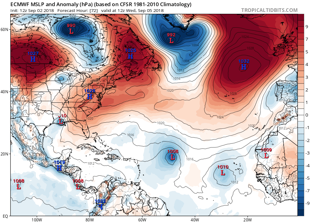
Just saying it as an opinion. Has a lot to work with when it moves past Florida. A lot to play out with it obviously but if it forms sooner rather than later or it slows down to take longer to hit the land it's probably going to see a pretty big shift in the forecast. Euro has been consistent on the track and it shows it dumping tons of water in Texas where it just slowly drifts westward without much steering it. GFS has it doing something completely different which is what we hope it does.
Posted on 9/2/18 at 11:56 am to deuce985
When would we start feeling the affects of the thing?
Posted on 9/2/18 at 11:57 am to Theboot32
Probably around Tuesday on the current forecast
Posted on 9/2/18 at 12:03 pm to TigerstuckinMS
frick, I was watching it early and thought it was going to the East Coast
Posted on 9/2/18 at 12:05 pm to deuce985
Dang, sooner than I thought, was hoping later in the week...
Posted on 9/2/18 at 12:08 pm to Theboot32
Euro has it hitting Wednesday but you'll probably start to feel it Tuesday night if it follows that path. The Euro hasn't changed the projected path much the past few days and GFS basically shifted right near it. They've been consistent on it being a weak storm and deadset on Louisiana/Miss. Where it goes past that they're both saying something totally different.
Posted on 9/2/18 at 12:13 pm to deuce985
When do the next model runs come out?
Posted on 9/2/18 at 12:16 pm to Red Solo Cup
GFS 0000 0600 1200 1800
Euro 0000 1200
Euro 0000 1200
Posted on 9/2/18 at 12:43 pm to Cosmo
Tropical Weather Outlook
NWS National Hurricane Center Miami FL
200 PM EDT Sun Sep 2 2018
For the North Atlantic...Caribbean Sea and the Gulf of Mexico:
The National Hurricane Center is issuing advisories on Tropical
Storm Florence, located several hundred miles west of the Cabo
Verde Islands.
Thunderstorm activity associated with a tropical wave located
between north-central Cuba and the central Bahamas is gradually
becoming better organized, and upper-level winds are also becoming
more favorable. A tropical depression is likely to form during the
next day or so while the system moves west-northwestward across the
northwestern Bahamas, southern Florida, and the Florida Keys. The
system is forecast to emerge over the southeastern Gulf of Mexico by
early Tuesday and move toward the north-central Gulf Coast Tuesday
night and Wednesday. This system will produce locally heavy rains
and gusty winds across the central and northwestern Bahamas,
southern Florida, and the Florida Keys during the next day or two. A
tropical storm watch could be issued for portions of the northern
Gulf Coast tonight. Interests in these areas should monitor the
progress of this system. For more information, see products from
your local weather forecast office and High Seas Forecasts issued by
the National Weather Service. An Air Force Reserve reconnaissance
aircraft is scheduled to investigate the system tomorrow.
* Formation chance through 48 hours...high...70 percent.
* Formation chance through 5 days...high...90 percent.
Posted on 9/2/18 at 12:44 pm to deuce985
quote:
I'm sorry but I'm really skeptical of this. I think it's going to form earlier than that depending on how fast it moves.
It's really too hard to make any kind of guess in this type of setup. The system is currently experiencing some what favorable conditions but that could change rapidly with the upper lows so close. It wouldn't take much to put the system right back under unfavourable conditions.
This post was edited on 9/2/18 at 12:52 pm
Posted on 9/2/18 at 12:46 pm to rds dc
Chances this makes a turn for Punta Cana?
Posted on 9/2/18 at 12:49 pm to lsuman25
quote:
A
tropical storm watch could be issued for portions of the northern
Gulf Coast tonight. Interests in these areas should monitor the
progress of this system
Ugh... Go straight to TD and don't do the squirrelly PTC advisory
Posted on 9/2/18 at 1:02 pm to Cosmo
quote:
Just passed NOLA costco. Gas line 20 cars deep
That’s every Sunday at that time. Key is to get there right when it opens.
Posted on 9/2/18 at 1:03 pm to lsuman25
quote:
A
tropical storm watch could be issued for portions of the northern
Gulf Coast tonight. Interests in these areas should monitor the
progress of this system.
I was wondering when watches/warnings would start coming out
Posted on 9/2/18 at 1:05 pm to rt3
Latest models seem weaker and slightly more east
Posted on 9/2/18 at 1:15 pm to Cosmo
Euro same place.

Posted on 9/2/18 at 1:39 pm to Hangover Haven
quote:
Yeah, they're already gassed up, and stocked up cans of Vienna sausage..
I have two cases of MRE's, a LifeStraw, and a Rambo knife.
I'm ready.
ETA: The eagle-eyed among you will notice that the Rambo knife is new. I'm always preparing and adding essential life-saving equipment.
This post was edited on 9/2/18 at 2:11 pm

 Page 17 of 400

Popular
Back to top