- My Forums
- Tiger Rant
- LSU Recruiting
- SEC Rant
- Saints Talk
- Pelicans Talk
- More Sports Board
- Winter Olympics
- Fantasy Sports
- Golf Board
- Soccer Board
- O-T Lounge
- Tech Board
- Home/Garden Board
- Outdoor Board
- Health/Fitness Board
- Movie/TV Board
- Book Board
- Music Board
- Political Talk
- Money Talk
- Fark Board
- Gaming Board
- Travel Board
- Food/Drink Board
- Ticket Exchange
- TD Help Board
Customize My Forums- View All Forums
- Show Left Links
- Topic Sort Options
- Trending Topics
- Recent Topics
- Active Topics
Started By
Message
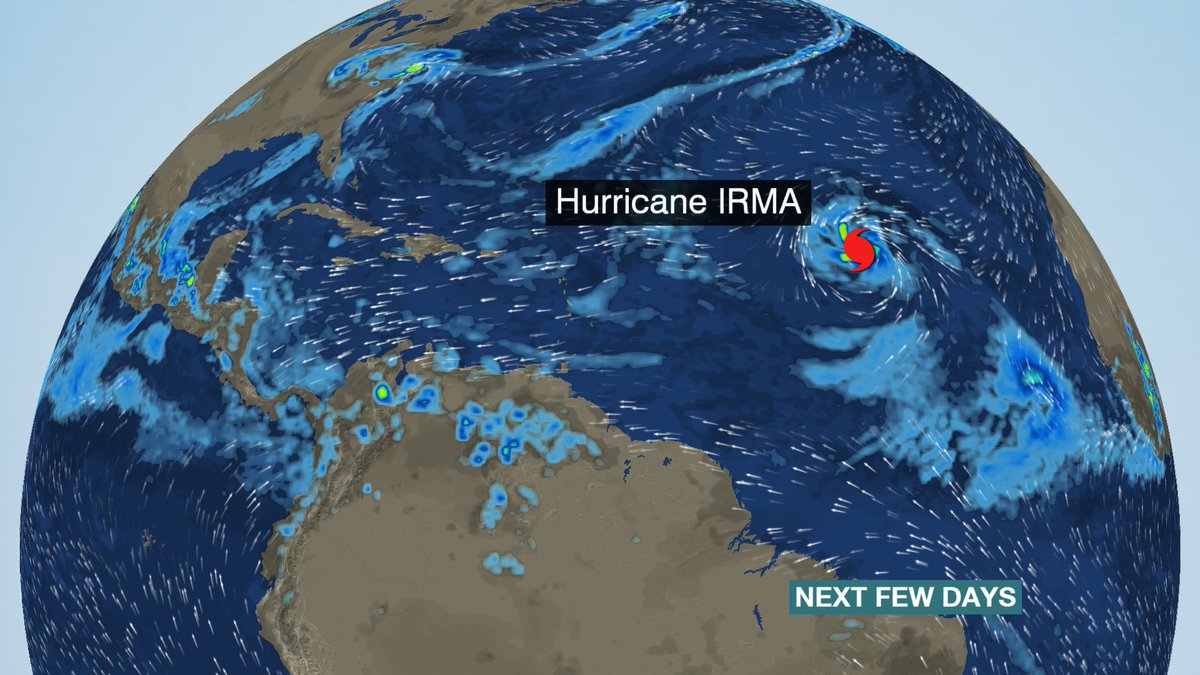
re: Hurricane Irma - Spinning Down
Posted on 8/31/17 at 4:05 pm to ForeverLSU02
Posted on 8/31/17 at 4:05 pm to ForeverLSU02
quote:
Is there any significance to this thing strengthening so far out? Shouldn't it help make recurve more likely?
Without that projected strong high pressure blocking it, yeah a stronger storm would naturally push farther north.
For those noticing the big intensity jump, if a storm has warm enough water and no shear to hamper it it'll get as strong as it possibly can. Stronger the winds, the more water vapor it picks up and the lower the pressure the more water is in the vapor phase for a given temperature. More water vapor, more heat to be released through condensation and that energy gets converted into higher winds. Higher winds, more water vapor to pick up...you get the idea.
There will be some eyewall replacements coming that will slow down intensification over 12-24 periods of time and the really warm water won't be there until the turn SW. That being said, conditions are obvious very good for supporting a very large and powerful hurricane.
 0
0


Posted on 8/31/17 at 4:05 pm to canyon
Dammit, one of these is going to ruin my redneck vacation to the panhandle in a couple of weeks, isn't it?

Posted on 8/31/17 at 4:09 pm to lsuman25
quote:
000
WTNT41 KNHC 312032
TCDAT1
Hurricane Irma Discussion Number 6
NWS National Hurricane Center Miami FL AL112017
500 PM AST Thu Aug 31 2017
Irma has become an impressive hurricane with intense eyewall
convection surrounding a small eye. Satellite estimates continue to
rapidly rise, and the Dvorak classifications from both TAFB & SAB
support an initial wind speed of 100 kt. This is a remarkable 50-kt
increase from yesterday at this time.
Microwave and satellite data suggest that an eyewall replacement
cycle could be starting. This isn't surprising given how small the
eye is, and will probably be the first of many eyewall cycles for
this hurricane. Overall, Irma should be in a low-shear environment
for several days, with the intensity controlled by eyewall cycles
and the moderately warm SSTs along the path. Thus the forecast
intensity is leveled off for the next 2 days. After the weekend,
Irma should be moving over much warmer water, with SSTs forecast to
be 29C at the end of the period. All indications are for Irma to be
strengthening by the end of the forecast period, with the NHC
prediction adjusted slightly upward from the previous one, in line
with the extremely low pressures forecast by the global and regional
hurricane models at that time.
Irma continues moving west-northwestward, now at about 10 kt.
There has been no change to the forecast philosophy, with the
hurricane likely to turn westward and west-southwestward over the
next few days due to a building ridge over the central Atlantic. At
long range, however, model guidance is not in good agreement on the
strength of the ridge, resulting in some significant north-south
differences in the global models. I am inclined to stay on the
southwestern side of the model guidance, given the rather consistent
forecasts of the ECMWF and its ensemble. In addition, the strongest
members of the recent ensembles are on the southern side on the
consensus, giving some confidence in that approach.
Time to MAGA
Posted on 8/31/17 at 4:10 pm to rds dc
Don't forget Matthew from last year, Euro and EPS were Gulf bound until they weren't. Euro is currently one of the farthest west models.
Posted on 8/31/17 at 4:38 pm to rds dc
18z GFS is running right now

Posted on 8/31/17 at 4:55 pm to rt3
quote:
...IRMA BECOMES A CATEGORY 3 HURRICANE OVER THE EASTERN ATLANTIC...

Posted on 8/31/17 at 5:11 pm to rt3
Wonder if the system behind Irma might be more of a threat way down the road.
Posted on 8/31/17 at 5:14 pm to lsuman25
Euro has nailed the last few storms ive watched closely.
Very scary
Very scary
Posted on 8/31/17 at 5:17 pm to rt3

Differences in current GFS run and the last euro run at the same time. Not a huge difference, but will yield a big difference in final location.
Good example of why the models decrease in accuracy as time goes on. A mistake carries through the next step and that resulting mistake goes into the next step and so on.
Got the image, and gist of the post from RL3AO at storm2k.
Posted on 8/31/17 at 5:22 pm to Duke
look how far south storm #2 is

Posted on 8/31/17 at 5:22 pm to Duke

The various Meterologists are saying they expect it to become a Cat 5 within the next 5 days.


Posted on 8/31/17 at 5:33 pm to ihometiger
looks like this run keeps Irma above 900 mb... peaking at 904
compared to 12z where it peaked at 898 mb
compared to 12z where it peaked at 898 mb
Posted on 8/31/17 at 5:35 pm to rt3
this GFS run looks like the sucks for NYC
ETA: that whole NY, NJ, NH, RI area
ETA: that whole NY, NJ, NH, RI area
This post was edited on 8/31/17 at 5:37 pm
Posted on 8/31/17 at 5:36 pm to rt3
Also has Jose crawling near the Leeward islands
Posted on 8/31/17 at 5:37 pm to lsuman25

Posted on 8/31/17 at 5:39 pm to rt3
quote:
this GFS run looks like the sucks for NYC
ETA: that whole NY, NJ, NH, RI area
I think I just heard every exec at the Weather Channel get hard.
Posted on 8/31/17 at 5:41 pm to Duke
quote:
heard every exec at the Weather Channel get hard.
That's a rare skill. I bet it's a blessing and a curse.
Posted on 8/31/17 at 5:44 pm to Duke
quote:
I think I just heard every exec at the Weather Channel get hard.
unfortunately though... GFS 6 hour ago had landfall in Maine or Nova Scotia
now... just 6 hours later... the computers move landfall to Rhode Island, Connecticut, Massachusetts
Euro barely moved between 1 AM & 1 PM today

This post was edited on 8/31/17 at 5:46 pm
Posted on 8/31/17 at 5:46 pm to rt3
meanwhile... here's comes potential Jose

ETA: GFS currently wants to hook potential Jose harmlessly out to sea (maybe Bermuda)... fingers crossed (also that it misses Bermuda)
ETA: GFS currently wants to hook potential Jose harmlessly out to sea (maybe Bermuda)... fingers crossed (also that it misses Bermuda)
This post was edited on 8/31/17 at 5:50 pm
Posted on 8/31/17 at 6:26 pm to ihometiger
quote:
The various Meterologists are saying they expect it to become a Cat 5 within the next 5 days.
I'm kinda freaked out. I still haven't even gotten my family back into our home from the 2016 flood.

 Page 14 of 711

Popular
Back to top