- My Forums
- Tiger Rant
- LSU Recruiting
- SEC Rant
- Saints Talk
- Pelicans Talk
- More Sports Board
- Winter Olympics
- Fantasy Sports
- Golf Board
- Soccer Board
- O-T Lounge
- Tech Board
- Home/Garden Board
- Outdoor Board
- Health/Fitness Board
- Movie/TV Board
- Book Board
- Music Board
- Political Talk
- Money Talk
- Fark Board
- Gaming Board
- Travel Board
- Food/Drink Board
- Ticket Exchange
- TD Help Board
Customize My Forums- View All Forums
- Show Left Links
- Topic Sort Options
- Trending Topics
- Recent Topics
- Active Topics
Started By
Message
re: Storm Tracking Thread: Post Tropical Storm Hermine
Posted on 8/31/16 at 7:43 pm to NorthEndZone
Posted on 8/31/16 at 7:43 pm to NorthEndZone
The hurricane hunter is finding some stronger winds.

Here's the storm over the last 48 hours... It looks like it's getting stronger in the last few frames.

This post was edited on 8/31/16 at 8:07 pm
 1
1


Posted on 8/31/16 at 7:52 pm to The Pirate King
Ugh gonna be a crappy Friday

Posted on 8/31/16 at 7:57 pm to GetCocky11
I guess my flight from BTR to Charlotte to Columbia on Friday night is frickED.
This post was edited on 8/31/16 at 7:58 pm
Posted on 8/31/16 at 8:21 pm to NewNameAgain
Not sure how much stronger this thing can really get when it has little to no organization in half of the NE and SW quadrants and nothing of note whatsoever in the NW quadrant.
This post was edited on 8/31/16 at 8:21 pm
Posted on 8/31/16 at 8:25 pm to slackster
quote:
Not sure how much stronger this thing can really get when it has little to no organization in half of the NE and SW quadrants and nothing of note whatsoever in the NW quadrant.
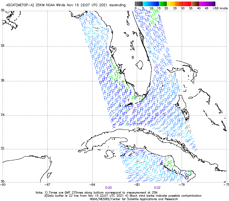
That image is actually from this morning but it certainly proves the point that the system is still a mess, esp. since current recon is still showing that the LLC is basically exposed to the NW:
Posted on 8/31/16 at 8:38 pm to slackster
Tropical Tidbits
Watch Levi's video from this evening. Start at the 2 minute mark. I've learned more from him in the past week than I've ever cared to know about tropical systems.
Watch Levi's video from this evening. Start at the 2 minute mark. I've learned more from him in the past week than I've ever cared to know about tropical systems.
This post was edited on 8/31/16 at 8:42 pm
Posted on 8/31/16 at 8:40 pm to rds dc
quote:
That image is actually from this morning
Is it really? I thought 1:02 UTC was 8:02 CDT?
ETA: I see at the bottom there is a 22 hr data buffer.
This post was edited on 8/31/16 at 8:41 pm
Posted on 8/31/16 at 8:41 pm to slackster
quote:
Is it really? I thought 1:02 UTC was 8:02 CDT?
The time stamp is at the bottom. I don't know what the time at the top represents
Posted on 8/31/16 at 8:47 pm to rds dc
Water vapor loop in the OP makes it look like it's moving almost due East.
Posted on 8/31/16 at 8:48 pm to rds dc
On a side note, I love how they appear to be using dropsondes basically from the moment they leave the tarmac.
Posted on 8/31/16 at 8:48 pm to NorthEndZone
quote:
ABOUT 330 MI...535 KM SSW OF APALACHICOLA FLORIDA ABOUT 330 MI...535 KM SW OF TAMPA FLORIDA
Does not compute. May be true but sure doesn't seem possible
Posted on 8/31/16 at 8:51 pm to slackster
quote:
On a side note, I love how they appear to be using dropsondes basically from the moment they leave the tarmac.
The Global Hawk mission from yesterday dropped 90!
Posted on 8/31/16 at 8:57 pm to Leadhead
quote:
ABOUT 330 MI...535 KM SSW OF APALACHICOLA FLORIDA ABOUT 330 MI...535 KM SW OF TAMPA FLORIDA
Does not compute. May be true but sure doesn't seem possible
The approximations are a little loose. Storm coordinates to Apalachicola are 526 km. 556 km to Tampa.

Posted on 8/31/16 at 8:57 pm to rds dc
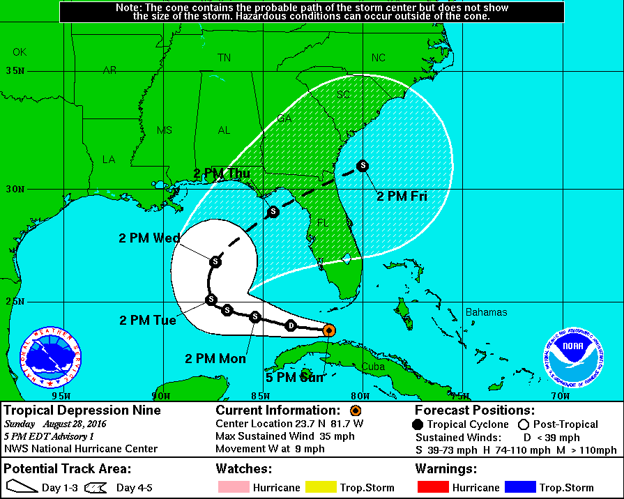
Just wanted to make one point - this storm is coming in very close to where originally forecast almost a week ago. The models have been pretty good in retrospect.
Thanks for the thread. The forecast for tomorrow for where I live is 8.4 inches of rain and 50 mph winds by midnight. And if there is a strong storm surge I may have salt water under my house. But I'm happy it's not headed to Louisiana. I've got a bunch of flooded relatives that don't need it.
Thanks for the thread. The forecast for tomorrow for where I live is 8.4 inches of rain and 50 mph winds by midnight. And if there is a strong storm surge I may have salt water under my house. But I'm happy it's not headed to Louisiana. I've got a bunch of flooded relatives that don't need it.
Posted on 8/31/16 at 8:59 pm to Python
It does look like it's moving ENE right now. Heading for Miami.
Posted on 8/31/16 at 9:01 pm to Tigris
quote:
Just wanted to make one point - this storm is coming in very close to where originally forecast almost a week ago
Also, the NHC has done great on this one, their first forecast is below:
Posted on 8/31/16 at 9:24 pm to rds dc
Yeah, I gotta hand it to them. They did great.

Posted on 8/31/16 at 9:24 pm to rds dc
Didn't I say the panhandle over a week ago????? Please refresh my memory.... Oh great storm tracker.......
Posted on 8/31/16 at 9:31 pm to dukke v
quote:
Didn't I say the panhandle over a week ago?????
Would you please shut the fck up?
Nobody cares.

Posted on 8/31/16 at 9:33 pm to notiger1997
Stop

 Page 162 of 175

Popular
Back to top