- My Forums
- Tiger Rant
- LSU Recruiting
- SEC Rant
- Saints Talk
- Pelicans Talk
- More Sports Board
- Winter Olympics
- Fantasy Sports
- Golf Board
- Soccer Board
- O-T Lounge
- Tech Board
- Home/Garden Board
- Outdoor Board
- Health/Fitness Board
- Movie/TV Board
- Book Board
- Music Board
- Political Talk
- Money Talk
- Fark Board
- Gaming Board
- Travel Board
- Food/Drink Board
- Ticket Exchange
- TD Help Board
Customize My Forums- View All Forums
- Show Left Links
- Topic Sort Options
- Trending Topics
- Recent Topics
- Active Topics
Started By
Message
re: Tropical Storm Cindy
Posted on 6/19/17 at 5:48 am to Jim Rockford
Posted on 6/19/17 at 5:48 am to Jim Rockford
We can handle 5"-7" over two days around here. It is a little more complicated by a TS possibly moving in to your west and SW. Winds would be out of the south, acting to push the rivers back a little bit. I stress a little bit, because this doesn't promise to be much of a surge maker.
We start looking at widespread 10"+ over the Amite and Tangi basins in the cards, you should start getting worried.
We start looking at widespread 10"+ over the Amite and Tangi basins in the cards, you should start getting worried.
 1
1


Posted on 6/19/17 at 5:50 am to Duke
Just spoke to a guy from BP. They're at a phase 2 right now, says they may bump to phase 3 today.
o Personnel secure the platform and leave in pre-determined
stages. A standard hurricane preparation process includes:
• Evacuation Phase 1 - Receive Storm Notification
o Review operations forecast.
o Communicate with air and marine transportation
providers.
o Perform safety system checks.
• Evacuation Phase 2 - Complete Preparations
o Secure all equipment.
o Test communications systems that enable monitoring
from shore.
o Evacuate non-essential personnel.
• Evacuation Phase 3 - Shut Down and Evacuation
o Shut-in wells and subsurface safety valves
o Close incoming and exit pipelines
o Shut down operating systems
o Transport remaining personnel to shore
Posted on 6/19/17 at 6:20 am to GEAUXmedic
I am confused as to which storm I should be focusing on. Is it the one down in the southern gulf?
Posted on 6/19/17 at 6:21 am to Janky
quote:
I am confused as to which storm I should be focusing on. Is it the one down in the southern gulf?
Yes.
Posted on 6/19/17 at 6:23 am to GEAUXmedic
Thanks.

Posted on 6/19/17 at 7:26 am to GEAUXmedic
It looks like the models are starting to come together in agreement on this thing from the last graph.
Posted on 6/19/17 at 7:26 am to Ponchy Tiger
quote:
If it does odds are we could see another March or August of 2016.
Let's pump the brakes a bit, the odds of two 1000 year floods in the same year are pretty slim.
Posted on 6/19/17 at 7:36 am to Creamer
March 2016 was a 500 year flood and August 2016 was a 1,000 year flood.
Posted on 6/19/17 at 7:38 am to GEAUXmedic
I'm interested to know if I'm seeing this correctly...it seems like at this point regardless of where the "center" goes, the vast majority of the rainfall will be to the east of the system? So even if the "center" makes "landfall" in Cameron parish, New Orleans and the Mississippi gulf coast are still going to see the bulk of the precipitation?
Posted on 6/19/17 at 7:40 am to Creamer
The diversion canal that was defunded and put on hold. I heard that after the big flood they were going to ramp that up. Does anybody know the status of that?
Also, for the weather experts. It seems as if this system is moving pretty damned fast. That is helpful in that it will not just hang out dropping rain. Are there any updates, by area on estimated rainfall?
Also, for the weather experts. It seems as if this system is moving pretty damned fast. That is helpful in that it will not just hang out dropping rain. Are there any updates, by area on estimated rainfall?

Posted on 6/19/17 at 7:45 am to TigerStripes06
The NE Quadrant of any Hurricane or Tropical system with counter clockwise rotation is where the vast majority of moisture, precipitation, thunderstorms and weather with potential to damage life and property comes from. The issue is that it can spin rain out far in advance of its arrival.
At this point there is no defined center. No wall forming. The satellite technology and the NHC have begun analyzing storms earlier to provide more advance warning. But the entire reason the Hurricane Hunter was cancelled yesterday is because there isn't enough organization to measure anything just yet.
You're seeing more warnings now not because it's a Hurricane or even a Tropical Storm as of now. You're seeing them because the NHC is tracking storms and issuing advisories earlier starting with this Hurricane Season.
Between this earlier tracking, August and March of 2016, folks are a bit more on edge which is understandable. But keep in mind these tracking and modeling services have never been used and publicized this early on. You're quite likely to see some drastic deviations from what happens vs what they are predicting now.
The next 24 hours will be much more informational. It will enter into the Gulf and that's when the accuracy and precision will start to drill down and improve.
ETA: Looking at the intensity modeling it also looks like the Gulf's lack of warm water will prevent intensification. From what I see, the highest strength will be tomorrow morning. It will slowly dissipate from there. By Friday it will not even be at Tropical Storm strength.
ETA 2: Graphic I'm talking about:
This post was edited on 6/19/17 at 7:56 am
Posted on 6/19/17 at 7:55 am to rds dc
Based on visible sat loops, it appears the low level center of circulation is trying to form about 100 miles N of the Yucatan. Roughly at 23N 88W.

This post was edited on 6/19/17 at 7:56 am
Posted on 6/19/17 at 7:56 am to NorthEndZone
quote:
Based on visible sat loops, it appears the low level center of circulation is trying to form about 100 miles N of the Yucatan. Roughly at 23N 88W.
This would move it more east IMO. Making the EURO solution less likely.

Posted on 6/19/17 at 7:59 am to GEAUXmedic
I work for a large oil company as well and can confirm that we are also in phase 2. Today should be pretty telling if the models begin to line up. Should be able to pin point direction fairly confidently.
Posted on 6/19/17 at 8:02 am to GFunk
quote:
ETA: Looking at the intensity modeling it also looks like the Gulf's lack of warm water will prevent intensification. From what I see, the highest strength will be tomorrow morning. It will slowly dissipate from there. By Friday it will not even be at Tropical Storm strength.
So it'll be a low kinda like we saw in August that will produce a shite ton of rain with not much wind? Which means as long as it doesn't stall, it won't be a complete shite show?
From what the local yokels have said this morning, there is a lot of wind shear off our coast that would hinder development, which correlates with what you said about gradual dissipation as early as tomorrow. Would that also push it farther east?
This post was edited on 6/19/17 at 8:06 am

Posted on 6/19/17 at 8:15 am to TigerStripes06
So what day is this blob supposed to hit us? Graphs are pointless without a timeframe.
Posted on 6/19/17 at 8:19 am to TigerStripes06
Shear is high so it'll be fighting along the way, but as a whole, we need to worry about where this thing ends up, how much rain it's pumping out, where it stalls etc. I wouldn't care too much whether it's called a tropical storm or not, it has the potential to drop a shite ton of rain, especially if it stalls off the coast for 48 hours like some models are showing.
Example: 06z HWRF:

Example: 06z HWRF:
This post was edited on 6/19/17 at 8:20 am
Posted on 6/19/17 at 8:21 am to GEAUXmedic
NHC has initialized their 12Z (7 AM CDT) models at 22.8N 88.1W
Posted on 6/19/17 at 8:25 am to NorthEndZone
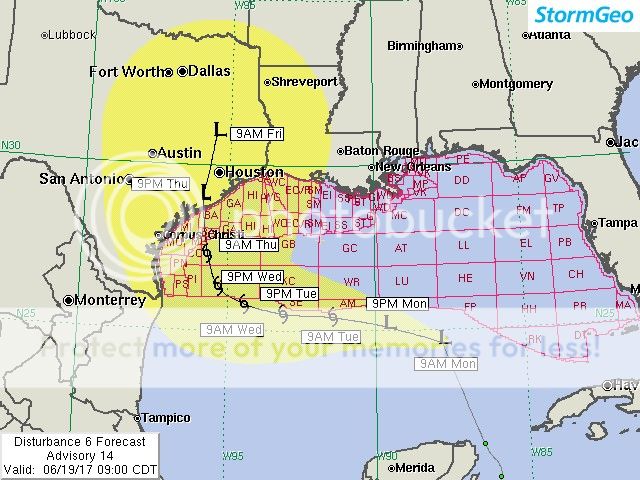
Just got this advisory at work (most recent):
"Key Points
1. We have relocated the center well north of our previous advisory position, but this does not change the projected track.
2. Landfall is projected for the middle Texas coast on Thursday as a tropical depression with winds up to 30 kts.
3. The greatest threat inland is expected to be heavy rainfall.
Our Forecast
The center of Disturbance 6 is difficult to locate this morning. Satellite imagery and surface observations indicate a large area of low pressure that extends from the northern Yucatan Peninsula to about 175 NM to the north of the Yucatan. While the low center overnight was closer to the Yucatan, we think that the center is in the process of reforming farther north, perhaps closer to 24N-25N latitude. The initial point of this advisory takes into account the reformation of the center. This center reformation had been predicted by the models and was expected, so it does not change our thinking as far as the forecast.
Model guidance has come into better agreement on a westerly track across the central Gulf tomorrow and Wednesday, and our track is in agreement. The center is forecast to track westward between 25N and 26N tomorrow and Wednesday. By late Wednesday or early Thursday, high pressure north of the storm should allow it to turn to the north toward the middle Texas coast. Landfall is projected for Thursday evening, but we do not expect there to be any heavy squalls near the actual center.
Concerning intensity, there is good agreement in the models that this storm will peak with winds in the 35 kts to 45 kts range within the next 24 hours. After then, some slow weakening is predicted. Our forecast takes the winds to 45 kts tonight and Tuesday morning then decreases the max sustained winds to about 40 kts Tuesday night and Wednesday. By Wednesday evening, winds are forecast to gradually drop below tropical storm strength as the center turns toward the Texas coast. The main impact across Texas and Louisiana will be from heavy rainfall, not wind. Rainfall amounts of 4-8 inches, or more, can be expected well to the east of the track across Texas on Thursday and Friday.
Expected Impacts On Land
Southern Louisiana: The outer rainbands have the potential to cause flooding. Severe thunderstorms and isolated tornadoes are also possible.
Texas Coast: The main impact will be from heavy rainfall, which could cause flooding in some areas."
ETA -
This post was edited on 6/19/17 at 8:35 am
Posted on 6/19/17 at 8:28 am to LSUfanNkaty
actual meteorologists seem to be pretty confident this will head toward Texas. we'll get a bunch of rain out of it but it won't be terrible.

 Page 14 of 105

Popular
Back to top