- My Forums
- Tiger Rant
- LSU Recruiting
- SEC Rant
- Saints Talk
- Pelicans Talk
- More Sports Board
- Winter Olympics
- Fantasy Sports
- Golf Board
- Soccer Board
- O-T Lounge
- Tech Board
- Home/Garden Board
- Outdoor Board
- Health/Fitness Board
- Movie/TV Board
- Book Board
- Music Board
- Political Talk
- Money Talk
- Fark Board
- Gaming Board
- Travel Board
- Food/Drink Board
- Ticket Exchange
- TD Help Board
Customize My Forums- View All Forums
- Show Left Links
- Topic Sort Options
- Trending Topics
- Recent Topics
- Active Topics
Started By
Message
re: Tropical Storm Isaias - O Canada!
Posted on 7/25/20 at 9:44 am to Roll Tide Ravens

Posted on 7/25/20 at 9:44 am to Roll Tide Ravens
Not sure if this will work or load.
 0
0

Posted on 7/25/20 at 9:47 am to rmnldr
quote:
Radar velocity picking up 102mph winds in the NW corner
Yeah I noticed some in the 90mph range earlier. Not sure if that is translating to the surface or not.
Posted on 7/25/20 at 9:51 am to Roll Tide Ravens
the cold water has done a number on Douglas
was a cat 4 and now down to a cat 2 and still a full day for the cold water to do more damage before the storm hits Hawaii
was a cat 4 and now down to a cat 2 and still a full day for the cold water to do more damage before the storm hits Hawaii
Posted on 7/25/20 at 9:54 am to rt3
The great Hawaiian forceshield :)
Used to live in Hawaii. We never took the hurricanes seriously until we could see them from the mountain because they usually broke up.
Used to live in Hawaii. We never took the hurricanes seriously until we could see them from the mountain because they usually broke up.
Posted on 7/25/20 at 9:58 am to rt3
Posted on 7/25/20 at 9:59 am to JAlohaM
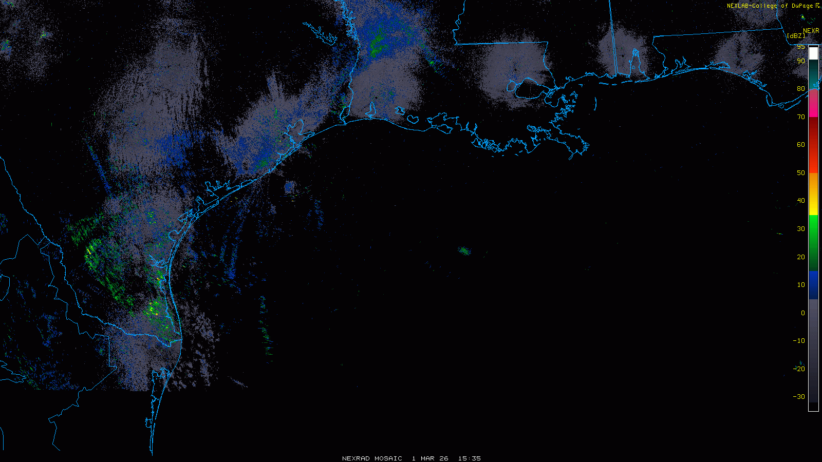
When you look at it from the Brownsville radar, you can see how impressive this band wrapping around from the south is.

Posted on 7/25/20 at 10:08 am to Roll Tide Ravens
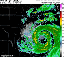
Credit to rdsdc for previously providing the link to the College of Dupage site...

This post was edited on 7/25/20 at 10:57 am
Posted on 7/25/20 at 10:10 am to NorthEndZone
TWC reporting 4.3 ft storm surge at the Bob Hall Pier in Corpus Christi
Posted on 7/25/20 at 10:37 am to rt3
It's now 5.35 feet above predicted tide and still rising.
Posted on 7/25/20 at 10:44 am to The Boat
quote:
It looks really nice on radar for a minimal hurricane
That disconnected eye wall is why it's a minimal hurricane.
Posted on 7/25/20 at 10:45 am to Roll Tide Ravens
quote:
When you look at it from the Brownsville radar, you can see how impressive this band wrapping around from the south is.
As someone once told me in a hurricane thread - think of how flooded the ocean must be right now.

Posted on 7/25/20 at 10:48 am to rt3
It’s trying to strengthen but the large center of circulation is keeping it from really bottoming out quickly.
Posted on 7/25/20 at 10:48 am to NorthEndZone
quote:
Credit to rdsdc for previously providing the link to the College of Dupage site...
That’s my go to for my forecasts.

Posted on 7/25/20 at 10:50 am to The Boat
The Selena statue will keep CC safe.

Posted on 7/25/20 at 10:52 am to slackster
The eyewall is a mess and very large..... but thanks for the weather lesson.... 
This post was edited on 7/25/20 at 10:53 am
Posted on 7/25/20 at 10:53 am to The Boat
Just happy that sucker is not sitting off La coast. 
Slow mover like this one can do some damage.
Slow mover like this one can do some damage.
Posted on 7/25/20 at 10:53 am to The Boat
quote:
It’s trying to strengthen but the large center of circulation is keeping it from really bottoming out quickly.
Yeah the last few IR and radar frames show it trying to clear out the center and consolidate the eyewall-lite features. Wouldn't be surprised if we get a few hours of a clear eye on IR right around landfall.

Posted on 7/25/20 at 10:58 am to slackster
Posted on 7/25/20 at 11:07 am to The Boat
quote:
It’s trying to strengthen but the large center of circulation is keeping it from really bottoming out quickly
A little friction from land interaction might actually help with the size problem. It'll sometimes help the eye tighten up a little on approach when they're big like this and not quite mature.

 Page 19 of 50

Popular
Back to top