- My Forums
- Tiger Rant
- LSU Recruiting
- SEC Rant
- Saints Talk
- Pelicans Talk
- More Sports Board
- Winter Olympics
- Fantasy Sports
- Golf Board
- Soccer Board
- O-T Lounge
- Tech Board
- Home/Garden Board
- Outdoor Board
- Health/Fitness Board
- Movie/TV Board
- Book Board
- Music Board
- Political Talk
- Money Talk
- Fark Board
- Gaming Board
- Travel Board
- Food/Drink Board
- Ticket Exchange
- TD Help Board
Customize My Forums- View All Forums
- Show Left Links
- Topic Sort Options
- Trending Topics
- Recent Topics
- Active Topics
Started By
Message


 0
0

Posted on 8/3/20 at 9:46 pm to Roll Tide Ravens
quote:
Cantore rocking his safety glasses in Wrightsville Beach. No helmet as of now.
Eyewall ain't there yet.
He should just wear a full suit of armor tbh.

Posted on 8/3/20 at 9:48 pm to Duke

Posted on 8/3/20 at 9:48 pm to Duke
Cantore should be in the worst of it over the next hour or so. What he had a few minutes ago was only about 50-60. That NE eyewall band will be whipping around toward him shortly.
This post was edited on 8/3/20 at 9:55 pm
Posted on 8/3/20 at 9:50 pm to NorthEndZone
The live stream from the Frying Pan tower would be great footage if it weren’t dark.
Posted on 8/3/20 at 9:55 pm to Roll Tide Ravens
The HRRR soundings for NYC tomorrow are fricking ridiculous.

Just 600-700 0-1 SRH.
Just 600-700 0-1 SRH.
Posted on 8/3/20 at 10:02 pm to Duke
I'm gonna need that translated to English, please
Posted on 8/3/20 at 10:03 pm to rt3
Cantore in the eye wall now.
This post was edited on 8/3/20 at 10:04 pm
Posted on 8/3/20 at 10:05 pm to rt3
quote:
I'm gonna need that translated to English, please
Atmosphere really fricking spinny.
The SRH #s for the Nashville tornado in March were 479 about the time of the tornado. It suggests an increased tornado risk up that way.
Posted on 8/3/20 at 10:07 pm to Duke
quote:
Atmosphere really fricking spinny.
The SRH #s for the Nashville tornado in March were 479 about the time of the tornado. It suggests an increased tornado risk up that way.
now that I understand
thanks
Posted on 8/3/20 at 10:07 pm to rt3
quote:
I'm gonna need that translated to English, please
shite’s twisty, baw
Posted on 8/3/20 at 10:18 pm to FutureMikeVIII
if only Isaias didn't have to fight shear basically it's whole track
this is like we were saying for Hanna... 1 or 2 more days was all the difference between a weak hurricane and a more significant storm
this is like we were saying for Hanna... 1 or 2 more days was all the difference between a weak hurricane and a more significant storm
Posted on 8/3/20 at 10:19 pm to rt3
landfall confirmed
quote:
Hurricane Isaias Tropical Cyclone Update
NWS National Hurricane Center Miami FL AL092020
1115 PM EDT Mon Aug 3 2020
Doppler radar imagery and surface observations indicate that eye of
Hurricane Isaias made landfall in southern North Carolina
around 1110 PM EDT (0310 UTC) near Ocean Isle Beach, with maximum
sustained winds of 85 mph (140 km/h).
A weather station at Oak Island, North Carolina, recently reported
sustained winds of 76 mph (122 km/h) and a gust to 87 mph (140
km/h).
A data buoy near the coast of North Carolina has recently reported
a minimum pressure of 988 MB (29.18 inches).
SUMMARY OF 1115 PM EDT...0315 UTC...INFORMATION
-----------------------------------------------
LOCATION...33.9N 78.4W
ABOUT 40 MI...65 KM SSW OF WILMINGTON NORTH CAROLINA
MAXIMUM SUSTAINED WINDS...85 MPH...140 KM/H
PRESENT MOVEMENT...NNE OR 20 DEGREES AT 22 MPH...35 KM/H
MINIMUM CENTRAL PRESSURE...988 MB...29.18 INCHES
$$
Forecaster Brown/Zelinsky/Beven
Posted on 8/3/20 at 10:22 pm to rt3
This has been one of the stranger storms.
Look it's best coming off Hispaniola. Pulsed from pretty good to terrible looking. Then tonight looks bad on satellite, good on radar and goes up to 85 from 70 in a couple hours.
Then is going to stay pretty strong into New England.
Look it's best coming off Hispaniola. Pulsed from pretty good to terrible looking. Then tonight looks bad on satellite, good on radar and goes up to 85 from 70 in a couple hours.
Then is going to stay pretty strong into New England.
Posted on 8/3/20 at 10:33 pm to Duke
quote:
Jeff Piotrowski
@Jeff_Piotrowski
A number of home & building fires. FD blocked by storm surge 2-6’ over the roads near the coast. A number people are trapped on second floors.

Posted on 8/3/20 at 10:35 pm to Bobby OG Johnson
Damn. Jeff doesn't bullsh!t either.
Cape Fear River surge...
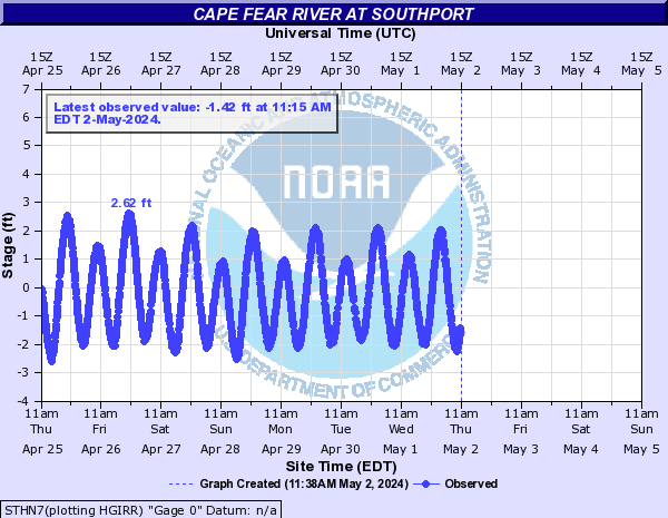
Cape Fear River surge...

Posted on 8/3/20 at 10:40 pm to NorthEndZone
anybody watching Cantore on TWC
Posted on 8/3/20 at 10:41 pm to LaBR4
Nah, about to turn in for some shut eye.
I hope he's being ridiculous.
I hope he's being ridiculous.
Posted on 8/3/20 at 10:45 pm to LaBR4
quote:
anybody watching Cantore
He was one strong gust and a slip in the wet grass from being rolled over a few minutes ago.
This post was edited on 8/3/20 at 10:47 pm
Posted on 8/3/20 at 11:10 pm to NorthEndZone
quote:
Massive Fire on Ocean isle west end, #Isaias


 Page 47 of 50

Popular
Back to top