- My Forums
- Tiger Rant
- LSU Recruiting
- SEC Rant
- Saints Talk
- Pelicans Talk
- More Sports Board
- Winter Olympics
- Fantasy Sports
- Golf Board
- Soccer Board
- O-T Lounge
- Tech Board
- Home/Garden Board
- Outdoor Board
- Health/Fitness Board
- Movie/TV Board
- Book Board
- Music Board
- Political Talk
- Money Talk
- Fark Board
- Gaming Board
- Travel Board
- Food/Drink Board
- Ticket Exchange
- TD Help Board
Customize My Forums- View All Forums
- Show Left Links
- Topic Sort Options
- Trending Topics
- Recent Topics
- Active Topics
Started By
Message
re: Miss River Flood Thread 2016, river back on the rise again.......
Posted on 12/31/15 at 12:43 pm to Voorhies7
Posted on 12/31/15 at 12:43 pm to Voorhies7
Then, in late 2011 to early 2012, the Corps put in place a more permanent solution by placing large amounts of dirt on the landward side to equalize the pressure in this area. The berm at the bottom of the levee was expanded 250 feet along about 1,500 feet of the levee length
Yeah, I am not the one to give quotes on dirt work, and there are a couple different prices used in different sources ($2 to 8 million). My point was that repair work was done on this part of the levee, and I shouldn't have used that one price.
Yeah, I am not the one to give quotes on dirt work, and there are a couple different prices used in different sources ($2 to 8 million). My point was that repair work was done on this part of the levee, and I shouldn't have used that one price.
 1
1

Posted on 12/31/15 at 12:48 pm to SurfOrYak
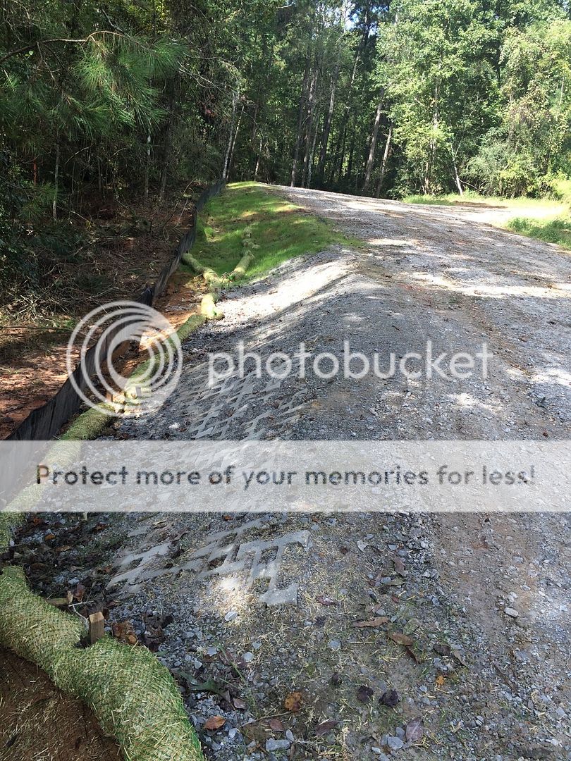
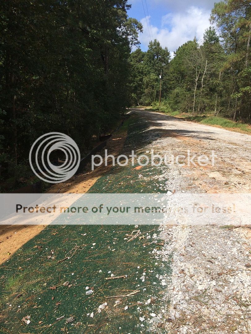
This is how you fix a slough off. This is some of my personal work in the Tuscaloosa. This road doesn't hold the importance as our levee system either. When something has to be done right the budget does equate into the project.
This post was edited on 12/31/15 at 12:49 pm
Posted on 12/31/15 at 12:52 pm to Voorhies7
Been working on the Miss river for 24 years. Lots of drama in this thread. The river will come up, some gates will be open and the river will go back down. Spoils will pop up here and there and the corp will keep them under control.
The river will not change its course and the sac au lait will be on fire from the bar pits in north la to the mouth of the basin.
So enjoy the rest of your hunting season and get the outboards ready for late February.
The river will not change its course and the sac au lait will be on fire from the bar pits in north la to the mouth of the basin.
So enjoy the rest of your hunting season and get the outboards ready for late February.
This post was edited on 12/31/15 at 12:55 pm
Posted on 12/31/15 at 1:04 pm to SurfOrYak
If you have any sand content in your soil & soil is exposed it is your enemy. Any erosion is problematic. It multiples with every drop of rain.
There is the right way of doing things & then there is the gov way.
The right way can get very expensive fast.
There is the right way of doing things & then there is the gov way.
The right way can get very expensive fast.
Posted on 12/31/15 at 1:23 pm to 633tiger
quote:
Been working on the Miss river for 24 years. Lots of drama in this thread. The river will come up, some gates will be open and the river will go back down. Spoils will pop up here and there and the corp will keep them under control. The river will not change its course and the sac au lait will be on fire from the bar pits in north la to the mouth of the basin. So enjoy the rest of your hunting season and get the outboards ready for late February.
No one here is saying, "The river is changing course".
I just can't see how anyone can say this far out that there is no chance of a failure. There are so many variables in play right now.
Posted on 12/31/15 at 1:34 pm to Voorhies7
Of course there's a chance. Let's just be realistic in those chances happening.
I think I read that your lively hood depends on the river (red?). So does mine. A high river brings me lots of work on the docks once it receeds. I'm looking forward to a busy and profitable summer.
I think I read that your lively hood depends on the river (red?). So does mine. A high river brings me lots of work on the docks once it receeds. I'm looking forward to a busy and profitable summer.
Posted on 12/31/15 at 1:45 pm to 633tiger
So.....will Avoyllese flood? Simple question. Give me all the possibilities!

Posted on 12/31/15 at 1:47 pm to MudEngineer318
Hey mud, can you email me, have a couple questions for ya.
greenhead2287@gmail
greenhead2287@gmail
Posted on 12/31/15 at 1:51 pm to 633tiger
Guess we are just looking at it differently. I think there is a realistic chance this will be the worst flood the since the levees have been built.
Without any failures or more rain it is forecasted top 3.
Without any failures or more rain it is forecasted top 3.
This post was edited on 12/31/15 at 2:02 pm

Posted on 12/31/15 at 3:03 pm to Voorhies7
It just depends on the long range conditions this spring. Too many variables to tell just yet. If this is a sharp peak and will fall fast, it seems to me there's just as much of a chance of it being normal by the time spring comes.
Posted on 12/31/15 at 3:05 pm to 633tiger
quote:
Lots of drama in this thread. The river will come up, some gates will be open and the river will go back down. Spoils will pop up here and there and the corp will keep them under control.
Amen to this.
The water is coming and people are being mobilized. Remember a lot of employees were off on leave for the holidays.
The Bonnet Carre Spillway will be open on the 8th or 9th. But looking at the projections the levels will be similar to 1997 when Morganza was not needed. Sure levels up north are high Just like they were in 1993. In 1993 neither Morganza or the BC was opened.
Settle down, enjoy the weekend and come ready to work next week is what I was told. Nothing is really happening in this area till next week.
Posted on 12/31/15 at 3:24 pm to MudEngineer318
Some of it probably will. Where you at?
Posted on 12/31/15 at 3:32 pm to ihometiger
quote:
Oil & Gas industry discovered a huge underwater river under the Miss River two years ago.
The "Missing River"
With Quotes like
quote:
With sea level rising as a result of climate change,
quote:
Then there’s the very contentious issue of what will happen to commercial fishing and shellfish harvesting if more fresh river water is diverted across levees in order to replenish wetlands along the collapsing coast
quote:
Oystermen and other commercial interests have sued the state to block these diversions on grounds that reduced salinity will destroy oyster beds and natural fish nurseries.
I can tell this article is sorta agenda driven.
but it all boils down to this
quote:
The net impact may be a wash. Because lower river levels reduce the flow of water through the sunken bayous, “there might be less of a difference than people would fear,” he said, adding that the evidence one way or the other is not yet in hand.
Pretty cool to know that these paleo channels exist though...they just need to leave the politics out of it...
Posted on 12/31/15 at 3:41 pm to ScottieP
quote:
Settle down, enjoy the weekend and come ready to work next week is what I was told. Nothing is really happening in this area till next week.
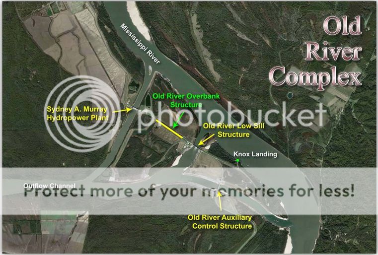
I thought they already opened the overbank structure. Or which area are you talking about?
Posted on 12/31/15 at 4:07 pm to 34venture
quote:
Some of it probably will. Where you at?
Camp is on the other side of the levee in Bville and I live Cottonporch!
Posted on 12/31/15 at 4:24 pm to ScottieP
Overbank structure opened for 3rd time since 1990
quote:
NEW ORLEANS – The U.S. Army Corps of Engineers opened the Old River Overbank Structure Dec. 30, 2015 when the Mississippi River was projected to reach the trigger of 52 feet at the Knox Landing gage. “This operation is one of our lessons learned from the 2011 flood that we have incorporated into our emergency response efforts,” said Mike Stack, Chief of the New Orleans District Emergency Management. “By opening the Overbank Structure now, we are adding another tool to help ensure we safely pass the required flow through the Old River Control Complex.” The Overbank Structure, only operated during high water events, increases the Corps’ ability to relieve pressure from the Auxiliary and Low-Sill structures, helping to reduce the potential for structural damages as a result of diverting large river flows. In accordance with the prescribed operation in the Water Control Manual, the Overbank Structure is opened in advance of water reaching the structure to limit the risk of operator safety during initial opening. Based on the most recent National Weather Service forecast, the river is expected to reach the sill of the structure on Friday, Jan. 1, 2016. This opening is the 15th time the structure has been operated and only the third time since 1990. When the structure was last operated in March 2015, flow reached a maximum of 9,000 cubic feet per second during a 158-day opening. The Overbank Structure is one of three Old River Control Complex structures designed to implement the 70/30 distribution rate between the Mississippi and Atchafalaya rivers. Throughout the year, the Corps operates the Auxiliary and Low-Sill structures to maintain the current distribution where 30 percent of the combined flow of the Mississippi and Red rivers is diverted into the Atchafalaya River. In total, the complex can discharge 700,000 cubic feet per second (approximately 300 million gallons per minute).
Posted on 12/31/15 at 5:05 pm to MudEngineer318
That's a big area. You up toward the levee or in the back by smith bay? It would have to stay high for a while to get up to the front.
Posted on 12/31/15 at 6:58 pm to ScottieP
ScottieP do you work for the Corp?
The reason I ask, the Corp has a permit that would allow the farmers in the Fore Bay to drain it. The corp in Morganza is having problems locating it. Any help or direction would be greatly appreciated.
The reason I ask, the Corp has a permit that would allow the farmers in the Fore Bay to drain it. The corp in Morganza is having problems locating it. Any help or direction would be greatly appreciated.
This post was edited on 12/31/15 at 7:31 pm
Posted on 12/31/15 at 11:54 pm to Voorhies7
quote:
ScottieP do you work for the Corp?
Nope. We do a lot of streamgage work for the CORP on a regular basis and are ramped up during high water. Spent all day Wed on conference calls with the CORP. The overbank area was discussed. at the time 6 bays were open and roughly 4-6" of water was in the gabion field.
quote:
The reason I ask, the Corp has a permit that would allow the farmers in the Fore Bay to drain it. The corp in Morganza is having problems locating it. Any help or direction would be greatly appreciated.
Can't help with this but I have wondered why the Fore Bay was not drained after high water last July.
This post was edited on 1/1/16 at 10:06 am
Posted on 1/1/16 at 12:08 am to ScottieP
Because the Corps can't find the permit. They have one & they are ok with the farmers doing it themselves. They litterly can't find the permit in there own system to allow them to do it legally. So if you can help through back channels, it would be greatly appreciated. User name @ gmail.com.
It would also help with the impending rise.
It would also help with the impending rise.

 Page 8 of 35

Popular
Back to top