- My Forums
- Tiger Rant
- LSU Recruiting
- SEC Rant
- Saints Talk
- Pelicans Talk
- More Sports Board
- Winter Olympics
- Fantasy Sports
- Golf Board
- Soccer Board
- O-T Lounge
- Tech Board
- Home/Garden Board
- Outdoor Board
- Health/Fitness Board
- Movie/TV Board
- Book Board
- Music Board
- Political Talk
- Money Talk
- Fark Board
- Gaming Board
- Travel Board
- Food/Drink Board
- Ticket Exchange
- TD Help Board
Customize My Forums- View All Forums
- Show Left Links
- Topic Sort Options
- Trending Topics
- Recent Topics
- Active Topics
Started By
Message

 3
3


Posted on 9/2/18 at 3:49 pm to lsuman25
Is there a tropical system sitting over LA right now?
Posted on 9/2/18 at 3:50 pm to lsuman25
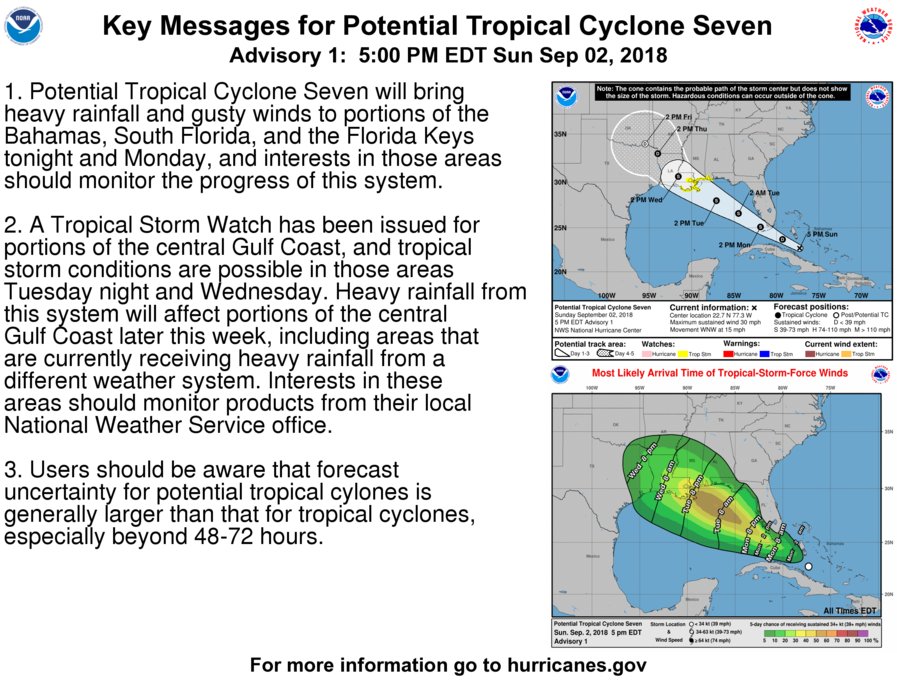
Potential Tropical Cyclone Seven Discussion Number 1
NWS National Hurricane Center Miami FL AL072018
500 PM EDT Sun Sep 02 2018
The area of disturbed weather associated with a tropical wave that
the NHC has been tracking for the past few days has become better
organized today. Strong winds previously associated with an upper-
level trough just west of the system have decreased significantly
during the day, and the upper-level flow across the disturbance has
become more anticyclonic. Earlier scatterometer wind data indicated
that the system does not yet have a closed surface circulation.
However, the same data indicate that winds of 25-28 kt exist outside
of thunderstorm activity, with some higher gusts likely present.
The initial intensity is being set at a conservative 25 kt for this
advisory.
The initial motion estimate is an uncertain 300/13 kt. The global
models are in excellent agreement that the strong subtropical ridge
to the north of the disturbance will remain entrenched across the
southeastern U.S. and mid-Atlantic states throughout the forecast
period. This flow pattern should keep the system moving in a west-
northwestward to northwestward motion until landfall occurs along
the central Gulf coast in 60-72 hours. The model tracks are tightly
packed, so the NHC official forecast track essentially lies down the
middle of the guidance envelope. On the forecast track, the system
is expected to move across the Florida Keys Monday afternoon, and
reach the central Gulf Coast by Tuesday night or Wednesday morning.
The aforementioned upper-level anticyclonic has been steadily
increasing during the day today, with weak cirrus outflow now
occurring in all quadrants. The disturbance is forecast to move
across the very warm waters of the Gulfstream late tonight and early
Monday morning where local diabatic heating should enhance deep
convection near the mid-level circulation, causing the vortex column
to build downward to the surface. Once a closed surface circulation
develops, the combination of low to modest vertical shear and SSTs
of at least 30C along the track should allow for at least slow but
steady strengthening. Although the official intensity forecast shows
weakening at 72 hours, this is due to the system expected to be
inland at that time. Conditions will favorable for continued
strengthening after the 48-h period until landfall occurs, and a
peak intensity of around 55 kt around 60 hours is possible. The
SHIPS and LGEM models were the only intensity guidance available for
this package, and the official forecast is just a little below an
average of those models. The HWRF and HMON models will be
forthcoming for the next advisory package, so some adjustments to
this first intensity forecast may be required as more guidance
becomes available.
Key Messages:
1. Potential Tropical Cyclone Seven will bring heavy rainfall and
gusty winds to portions of the Bahamas, South Florida, and the
Florida Keys tonight and Monday, and interests in those areas should
monitor the progress of this system.
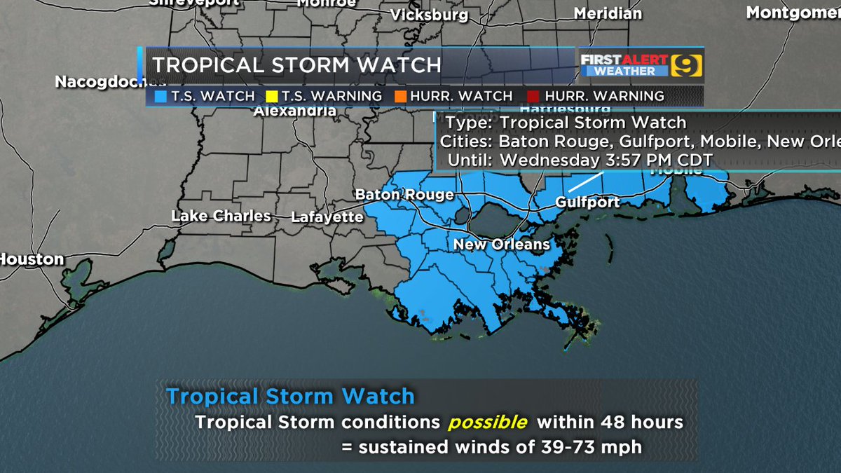
2. A Tropical Storm Watch has been issued for portions of the
central Gulf Coast, and tropical storm conditions are possible in
those areas Tuesday night and Wednesday. Heavy rainfall from this
system will affect portions of the central Gulf Coast later this
week, including areas that are currently receiving heavy rainfall
from a different weather system. Interests in these areas should
monitor products from their local National Weather Service office.
3. Users should be aware that forecast uncertainty for potential
tropical cylones is generally larger than that for tropical
cyclones, especially beyond 48-72 hours.
FORECAST POSITIONS AND MAX WINDS
INIT 02/2100Z 22.7N 77.3W 25 KT 30 MPH...POTENTIAL TROP CYCLONE
12H 03/0600Z 23.7N 79.3W 30 KT 35 MPH...TROPICAL DEPRESSION
24H 03/1800Z 25.1N 81.9W 35 KT 40 MPH
36H 04/0600Z 26.6N 84.5W 40 KT 45 MPH
48H 04/1800Z 28.0N 87.1W 50 KT 60 MPH
72H 05/1800Z 30.6N 91.6W 35 KT 40 MPH...INLAND
96H 06/1800Z 33.0N 94.0W 25 KT 30 MPH...INLAND
120H 07/1800Z 34.0N 95.5W 20 KT 25 MPH...POST-TROP/REMNT LOW
$$
Forecaster Stewart
NWS National Hurricane Center Miami FL AL072018
500 PM EDT Sun Sep 02 2018
The area of disturbed weather associated with a tropical wave that
the NHC has been tracking for the past few days has become better
organized today. Strong winds previously associated with an upper-
level trough just west of the system have decreased significantly
during the day, and the upper-level flow across the disturbance has
become more anticyclonic. Earlier scatterometer wind data indicated
that the system does not yet have a closed surface circulation.
However, the same data indicate that winds of 25-28 kt exist outside
of thunderstorm activity, with some higher gusts likely present.
The initial intensity is being set at a conservative 25 kt for this
advisory.
The initial motion estimate is an uncertain 300/13 kt. The global
models are in excellent agreement that the strong subtropical ridge
to the north of the disturbance will remain entrenched across the
southeastern U.S. and mid-Atlantic states throughout the forecast
period. This flow pattern should keep the system moving in a west-
northwestward to northwestward motion until landfall occurs along
the central Gulf coast in 60-72 hours. The model tracks are tightly
packed, so the NHC official forecast track essentially lies down the
middle of the guidance envelope. On the forecast track, the system
is expected to move across the Florida Keys Monday afternoon, and
reach the central Gulf Coast by Tuesday night or Wednesday morning.
The aforementioned upper-level anticyclonic has been steadily
increasing during the day today, with weak cirrus outflow now
occurring in all quadrants. The disturbance is forecast to move
across the very warm waters of the Gulfstream late tonight and early
Monday morning where local diabatic heating should enhance deep
convection near the mid-level circulation, causing the vortex column
to build downward to the surface. Once a closed surface circulation
develops, the combination of low to modest vertical shear and SSTs
of at least 30C along the track should allow for at least slow but
steady strengthening. Although the official intensity forecast shows
weakening at 72 hours, this is due to the system expected to be
inland at that time. Conditions will favorable for continued
strengthening after the 48-h period until landfall occurs, and a
peak intensity of around 55 kt around 60 hours is possible. The
SHIPS and LGEM models were the only intensity guidance available for
this package, and the official forecast is just a little below an
average of those models. The HWRF and HMON models will be
forthcoming for the next advisory package, so some adjustments to
this first intensity forecast may be required as more guidance
becomes available.
Key Messages:
1. Potential Tropical Cyclone Seven will bring heavy rainfall and
gusty winds to portions of the Bahamas, South Florida, and the
Florida Keys tonight and Monday, and interests in those areas should
monitor the progress of this system.
2. A Tropical Storm Watch has been issued for portions of the
central Gulf Coast, and tropical storm conditions are possible in
those areas Tuesday night and Wednesday. Heavy rainfall from this
system will affect portions of the central Gulf Coast later this
week, including areas that are currently receiving heavy rainfall
from a different weather system. Interests in these areas should
monitor products from their local National Weather Service office.
3. Users should be aware that forecast uncertainty for potential
tropical cylones is generally larger than that for tropical
cyclones, especially beyond 48-72 hours.
FORECAST POSITIONS AND MAX WINDS
INIT 02/2100Z 22.7N 77.3W 25 KT 30 MPH...POTENTIAL TROP CYCLONE
12H 03/0600Z 23.7N 79.3W 30 KT 35 MPH...TROPICAL DEPRESSION
24H 03/1800Z 25.1N 81.9W 35 KT 40 MPH
36H 04/0600Z 26.6N 84.5W 40 KT 45 MPH
48H 04/1800Z 28.0N 87.1W 50 KT 60 MPH
72H 05/1800Z 30.6N 91.6W 35 KT 40 MPH...INLAND
96H 06/1800Z 33.0N 94.0W 25 KT 30 MPH...INLAND
120H 07/1800Z 34.0N 95.5W 20 KT 25 MPH...POST-TROP/REMNT LOW
$$
Forecaster Stewart
Posted on 9/2/18 at 3:50 pm to rds dc
Discussion indicates that initial intensity forecast may be on the conservative side.
This post was edited on 9/2/18 at 3:52 pm

Posted on 9/2/18 at 3:52 pm to rds dc
Get Gordon Get It Done!

Posted on 9/2/18 at 3:54 pm to rds dc
I thought you meant we were having a hurricane party at florabama
Posted on 9/2/18 at 3:59 pm to rds dc
My wife was supposed to be flying out of MSY at 6:30 Wed morning. Looks like I won't have to wake my arse up to drive her to the airport 
Posted on 9/2/18 at 4:00 pm to rds dc

This post was edited on 9/2/18 at 4:01 pm
Posted on 9/2/18 at 4:01 pm to rds dc
Posted on 9/2/18 at 4:01 pm to GEAUXT
New Orleans better hope those pumps are working when they got flooded by an afternoon shower in low lying areas.
Posted on 9/2/18 at 4:04 pm to lsuman25

Posted on 9/2/18 at 4:14 pm to tossedoff
(no message)
This post was edited on 9/2/18 at 4:15 pm
Posted on 9/2/18 at 4:17 pm to tossedoff
So it gets through the gulf pretty fast, but slows down significantly over LA... fantastic.
Posted on 9/2/18 at 4:18 pm to lsuman25
How much rain are we potentially looking at? Any indication that this thing could stall over land?
Posted on 9/2/18 at 4:22 pm to PhilemonThomas
If the center makes landfall south of the river and goes NW, then stalls, it will trigger flooding in a lot of low areas around the lake.
Posted on 9/2/18 at 4:28 pm to WylieTiger
Shea Ryan, the meteorologist at Tampa's ABC affiliate said early this morning that the shear is going to keep it from forming. Has this changed?
I kind of love her a little so I hope she is right.
I kind of love her a little so I hope she is right.
Posted on 9/2/18 at 4:29 pm to PhilemonThomas
The rain totals were looking much worse yesterday. Today most are around 6 inches or so. I’d say a good bet would be 3-8 inches. But time for that to change. I don’t see major flooding from that since it won’t be over a short period. We can handle that. The 15+ totals yesterday were scarier.
Who is the first school system to cancel and when? Tuesday and Wednesday or just Wednesday?
Who is the first school system to cancel and when? Tuesday and Wednesday or just Wednesday?
This post was edited on 9/2/18 at 4:30 pm
Posted on 9/2/18 at 4:41 pm to GEAUXT
quote:
My wife was supposed to be flying out of MSY at 6:30 Wed morning. Looks like I won't have to wake my arse up to drive her to the airport ?
I supposed to by flying IN from Boston at 10 AM on Wednesday, sooooo....
Posted on 9/2/18 at 4:42 pm to Hangit
It was projected to keep it from getting organized today but the adverse conditions against the storm have tapered off faster than the original forecast said. That's why it has been getting better organized today. It's probably going to be stronger than they originally thought by the time it hits land.
This post was edited on 9/2/18 at 4:43 pm

 Page 19 of 400

Popular
Back to top