- My Forums
- Tiger Rant
- LSU Recruiting
- SEC Rant
- Saints Talk
- Pelicans Talk
- More Sports Board
- Winter Olympics
- Fantasy Sports
- Golf Board
- Soccer Board
- O-T Lounge
- Tech Board
- Home/Garden Board
- Outdoor Board
- Health/Fitness Board
- Movie/TV Board
- Book Board
- Music Board
- Political Talk
- Money Talk
- Fark Board
- Gaming Board
- Travel Board
- Food/Drink Board
- Ticket Exchange
- TD Help Board
Customize My Forums- View All Forums
- Show Left Links
- Topic Sort Options
- Trending Topics
- Recent Topics
- Active Topics
Started By
Message

 0
0

Posted on 7/17/17 at 6:11 pm to GEAUXmedic
What's forecast on that? Looks like it's heading far west which I don't like.
Posted on 7/17/17 at 6:19 pm to lsuman25
quote:
officially have TS Don
Well, that was sort of quick.
(TWSS)
Posted on 7/17/17 at 6:25 pm to deuce985
I think they expect it to weaken in the Caribbean due to wind shear

Posted on 7/17/17 at 7:12 pm to biohzrd
quote:well he is working with Jen Carfagno, Stephanie Abrams and Maria LaRosa on a daily basis.
Cantore may have the biggest hard on of his life.


Posted on 7/18/17 at 12:54 am to rds dc
Is this just hype from Dr. Jeff Masters?
LINK
LINK
quote:
Bret and Don: harbingers of an active hurricane season?
We’ve now had four named storms this year: Arlene, Bret, Cindy and Don. The fourth named storm of the year doesn’t typically form until around Aug. 23, based on the 1966-2009 average. The first hurricane of the year usually arrives by August 10; so far none of this year’s storm have become hurricanes.
Don is likely to be the second tropical storm to affect the Lesser Antilles Islands this year. According to NOAA’s Historical Hurricanes site, this would be the first year on record for the islands to see two tropical storms before August 1. There were two other years that came close: in 2005, Hurricane Emily passed though the islands on July 14, and the tropical depression that would become Hurricane Dennis passed through on July 4. In 1933, a tropical depression passed though the islands on July 14, and a tropical storm hit on July 25. It should give no one comfort that these were the two busiest Atlantic hurricane seasons on record!
Posted on 7/18/17 at 1:42 am to GEAUXmedic
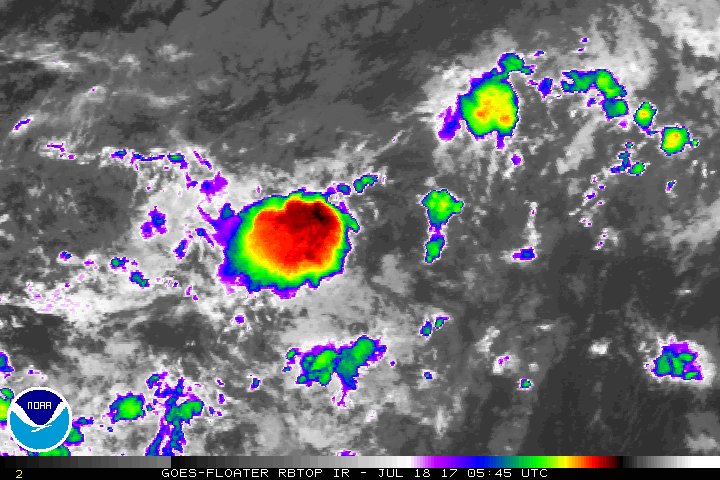
Now we have Invest 96L.
ATCF Best Track
System ID: AL96 (INVEST)
0600 UTC Jul 18, 2017
Location: 10.4°N, 37.4°W
Central Pressure: 1010 mb
Maximum Winds (1-min): 25 kt (29 mph)
Type: Disturbance (DB)

ATCF Best Track
System ID: AL96 (INVEST)
0600 UTC Jul 18, 2017
Location: 10.4°N, 37.4°W
Central Pressure: 1010 mb
Maximum Winds (1-min): 25 kt (29 mph)
Type: Disturbance (DB)
quote:
Tropical Weather Outlook
NWS National Hurricane Center Miami FL
200 AM EDT Tue Jul 18 2017
For the North Atlantic...Caribbean Sea and the Gulf of Mexico:
The National Hurricane Center is issuing advisories on Tropical
Storm Don, located about 300 miles east-southeast of Barbados.
A tropical wave, accompanied by a well-defined low pressure system,
is located over the central tropical Atlantic several hundred miles
west-southwest of the Cabo Verde Islands. Some gradual development
of this system is possible through mid-week while it moves toward
the west-northwest or northwest at 10 to 15 mph. After that time,
environmental conditions are forecast to become less conducive for
development.
* Formation chance through 48 hours...low...30 percent.
* Formation chance through 5 days...medium...40 percent.
This post was edited on 7/18/17 at 1:45 am
Posted on 7/18/17 at 1:53 am to GEAUXmedic
Don will go poof in the Caribbean as a tropical storm either at sea or central america, and the other invest is gone out into the atlantic
Quiet after that
We'll see what that YUGE upper level low sitting in the atlantic does in time, that thing is likely to suck anything away that develops quickly in the atlantic
Quiet after that
We'll see what that YUGE upper level low sitting in the atlantic does in time, that thing is likely to suck anything away that develops quickly in the atlantic
Posted on 7/18/17 at 1:56 am to DVinBR
I basically agree. Still unnerving for all this activity in this area so early. Once August hits it'll ramp up for us here. I think Invest 96L has a better shot than Don thouugh.
This post was edited on 7/18/17 at 2:17 am
Posted on 7/18/17 at 2:10 am to GEAUXmedic

Posted on 7/18/17 at 6:17 am to GEAUXmedic
quote:
Is this just hype from Dr. Jeff Masters?
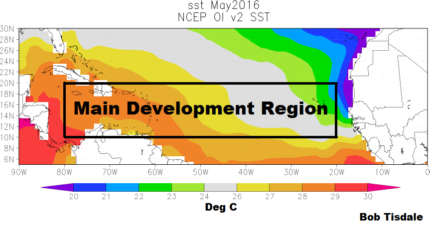
2017 is the 12th season to see an MDR this active before 8/1 but the quality of systems hasn't been impressive so far in '17. ACE is actually still below normal for the season even though we have already reached Don. Remember, '05 had already seen two powerful hurricanes by now with Dennis and Emily. So, this number of named MDR systems is certainly a bad omen but at least they haven't been very impressive. I'm a believer that number of named storms isn't really a good indicator and that ACE is where to look.
This post was edited on 7/18/17 at 6:26 am
Posted on 7/18/17 at 6:44 am to rds dc
quote:
MDR
So, us lazy folks don't have to go away and Google this, what is MDR?
Posted on 7/18/17 at 7:02 am to East Coast Band
quote:
So, us lazy folks don't have to go away and Google this, what is MDR?
Thanks for asking that, I have no idea that that means.
What is Ace?
Posted on 7/18/17 at 7:11 am to Beessnax
Posted on 7/18/17 at 7:19 am to Beessnax
Noaa glossary has neither ace nor mdr.
Posted on 7/18/17 at 7:41 am to rds dc
Recon is in Don right now, either the circulation has fallen apart, reformed in another location, or they missed the mark.
Posted on 7/18/17 at 7:46 am to rds dc
Thanks
Posted on 7/18/17 at 8:20 am to Ponchy Tiger
quote:
well he is working with Jen Carfagno, Stephanie Abrams and Maria LaRosa on a daily basis.
pics?
Posted on 7/18/17 at 8:57 am to GEAUXmedic
quote:
Recon is in Don right now, either the circulation has fallen apart, reformed in another location, or they missed the mark.
850 vort analysis this morning showed kind of a strung out vort. So maybe its elongated or has more than one low level eddy in the larger wave axis?

 Page 7 of 9

Popular
Back to top