- My Forums
- Tiger Rant
- LSU Recruiting
- SEC Rant
- Saints Talk
- Pelicans Talk
- More Sports Board
- Winter Olympics
- Fantasy Sports
- Golf Board
- Soccer Board
- O-T Lounge
- Tech Board
- Home/Garden Board
- Outdoor Board
- Health/Fitness Board
- Movie/TV Board
- Book Board
- Music Board
- Political Talk
- Money Talk
- Fark Board
- Gaming Board
- Travel Board
- Food/Drink Board
- Ticket Exchange
- TD Help Board
Customize My Forums- View All Forums
- Show Left Links
- Topic Sort Options
- Trending Topics
- Recent Topics
- Active Topics
Started By
Message
re: New thread started for Beryl
Posted on 6/17/24 at 8:39 am to RummelTiger
Posted on 6/17/24 at 8:39 am to RummelTiger
Give him your what?
 1
1


Posted on 6/17/24 at 8:45 am to RummelTiger
quote:
will gladly give you my 6" so you can rest easier.

Posted on 6/17/24 at 8:46 am to aTmTexas Dillo
quote:
But they are still saying the sea temperatures are out of this world hot.
Sea surface temperatures are currently above average across much of the Atlantic Basin. That said, sea surface temps are just one part of the story.
Posted on 6/17/24 at 11:53 am to rds dc
Here is some 200+ hour fun from the 12z GFS. Two tropical systems in the Gulf. Not likely to happen.

This post was edited on 6/17/24 at 11:54 am
Posted on 6/17/24 at 11:56 am to Roll Tide Ravens
That might be the something big my guy was telling me about

Posted on 6/17/24 at 11:57 am to Crimsonians
quote:
Give him your what?
My 6".
I'm in the Austin area and we're supposed to get 6" of rain from this.
What did you think I meant?
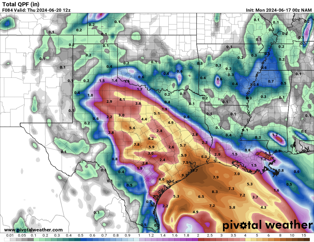
Posted on 6/17/24 at 12:03 pm to RummelTiger
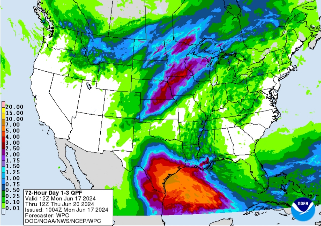
Day 1-3 QPF
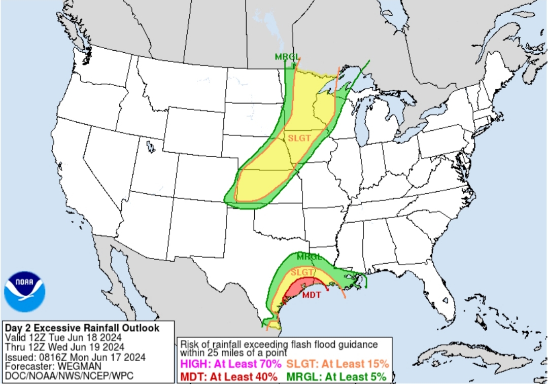
Day 2 Excessive Rainfall Outlook
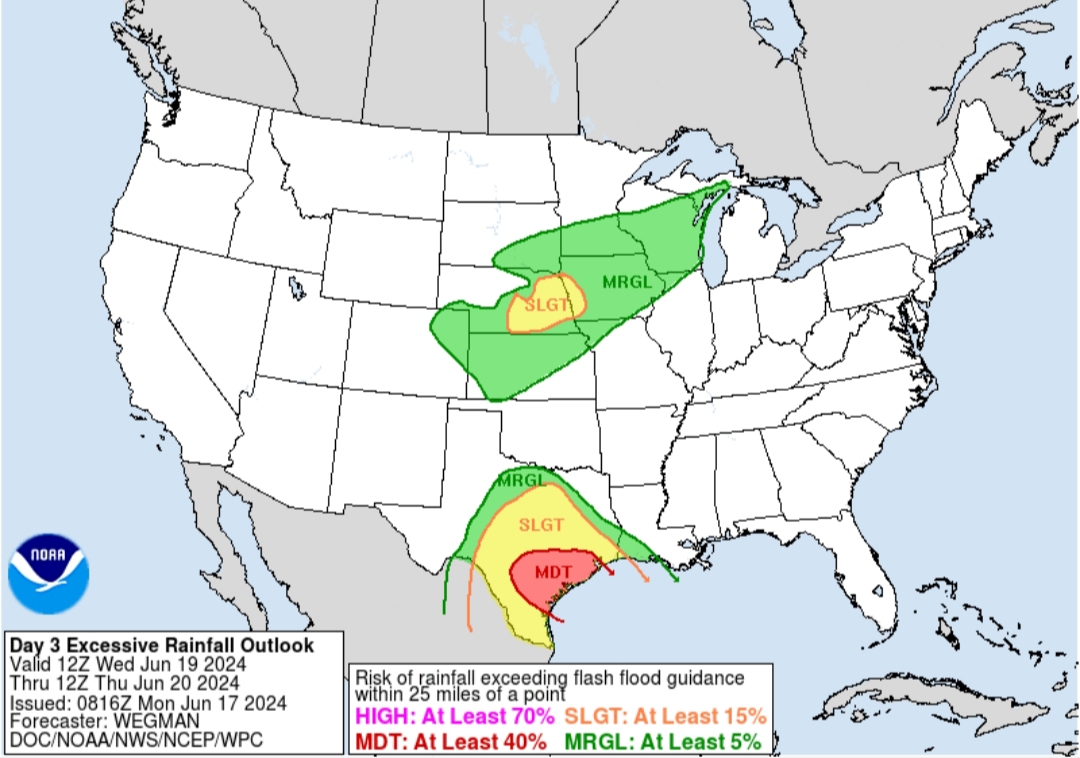
Day 3 Excessive Rainfall Outlook
Day 2 Excessive Rainfall Outlook
Day 3 Excessive Rainfall Outlook
Posted on 6/17/24 at 12:13 pm to Roll Tide Ravens
quote:
Here is some 200+ hour fun from the 12z GFS. Two tropical systems in the Gulf. Not likely to happen.
Conditions look to be favorable for a bit. The 00z Euro EPS also had some support for another system out beyond Day 7.
It looks like 91L might do enough to get a name before moving inland. However, if it doesn't, then you can probably start chipping away at some of those high storm total seasonal predictions. If you look back at the hyperactive seasons, they almost always had multiple named storms in June.
Posted on 6/17/24 at 12:22 pm to LegendInMyMind
quote:
Day 1-3 QPF
Far West Texas and the Big Bend area are really hurting. Hopefully, this follows model guidance and brings the rain where it is needed.


Posted on 6/17/24 at 1:04 pm to rds dc

Posted on 6/17/24 at 1:12 pm to Roll Tide Ravens

The OT vs You
Posted on 6/17/24 at 1:22 pm to Roll Tide Ravens
quote:
Here is some 200+ hour fun from the 12z GFS. Two tropical systems in the Gulf. Not likely to happen.
Remember anything longer than 5 days out is pretty much a best guess and should be looked upon as for educational or entertainment purposes only.
But yes, 200 hours out is definitely “fun.”
Posted on 6/17/24 at 2:00 pm to Tarps99
quote:
Remember anything longer than 5 days out is pretty much a best guess and should be looked upon as for educational or entertainment purposes only.

Posted on 6/17/24 at 2:01 pm to Tarps99
While not strong 12Z Euro is like surprise motherfrickers for Louisiana. This is day 9 and 10 so will change. 
Posted on 6/17/24 at 3:19 pm to lsuman25
Special Message from NHC Issued 17 Jun 2024 20:17 UTC
NHC will initiate advisories on Potential Tropical Cyclone One, located over the southwestern Gulf of Mexico, at 400 PM CDT (2100 UTC).
NHC will initiate advisories on Potential Tropical Cyclone One, located over the southwestern Gulf of Mexico, at 400 PM CDT (2100 UTC).
Posted on 6/17/24 at 3:22 pm to rds dc
PTC One coming at 4:00 PM CT.
That will allow NHC to start issuing advisories and allow tropical storm watches/warnings to be issued.
That will allow NHC to start issuing advisories and allow tropical storm watches/warnings to be issued.
This post was edited on 6/17/24 at 3:24 pm
Posted on 6/17/24 at 3:26 pm to lsuman25
quote:
While not strong 12Z Euro is like surprise motherfrickers for Louisiana
Some of the “ not strong” storms cause a lot problems.

Posted on 6/17/24 at 3:26 pm to RummelTiger
quote:
My 6".
Posted on 6/17/24 at 3:53 pm to rds dc
BULLETIN
Potential Tropical Cyclone One Advisory Number 1
NWS National Hurricane Center Miami FL AL012024
400 PM CDT Mon Jun 17 2024
...LOW PRESSURE AREA OVER THE BAY OF CAMPECHE EXPECTED TO BRING
HEAVY RAINFALL THREAT TO PARTS OF THE WESTERN GULF COAST...
...TROPICAL STORM WATCH ISSUED FOR PARTS OF THE COAST OF TEXAS AND
NORTHEASTERN MEXICO...
SUMMARY OF 400 PM CDT...2100 UTC...INFORMATION
----------------------------------------------
LOCATION...20.3N 93.2W
ABOUT 380 MI...615 KM SE OF LA PESCA MEXICO
ABOUT 470 MI...755 KM SE OF BROWNSVILLE TEXAS
MAXIMUM SUSTAINED WINDS...40 MPH...65 KM/H
PRESENT MOVEMENT...NNW OR 345 DEGREES AT 7 MPH...11 KM/H
MINIMUM CENTRAL PRESSURE...1001 MB...29.56 INCHES
Posted on 6/17/24 at 3:56 pm to Roll Tide Ravens
This is going to ruin my Juneteenth celebration.

 Page 15 of 39

Popular
Back to top