- My Forums
- Tiger Rant
- LSU Recruiting
- SEC Rant
- Saints Talk
- Pelicans Talk
- More Sports Board
- Winter Olympics
- Fantasy Sports
- Golf Board
- Soccer Board
- O-T Lounge
- Tech Board
- Home/Garden Board
- Outdoor Board
- Health/Fitness Board
- Movie/TV Board
- Book Board
- Music Board
- Political Talk
- Money Talk
- Fark Board
- Gaming Board
- Travel Board
- Food/Drink Board
- Ticket Exchange
- TD Help Board
Customize My Forums- View All Forums
- Show Left Links
- Topic Sort Options
- Trending Topics
- Recent Topics
- Active Topics
Started By
Message
re: Tropical Storm Isaias - O Canada!
Posted on 7/24/20 at 9:41 pm to Duke
Posted on 7/24/20 at 9:41 pm to Duke
quote:
Depends on how long you're planning to live I suppose but it's going to take a long time to get weather accurate at the month scale.
Let's say I've got 55 years left if I stop eating red meat at my current clip...
I like my chances.
 1
1


Posted on 7/24/20 at 9:45 pm to slackster

Posted on 7/24/20 at 9:48 pm to Roll Tide Ravens
Hanna is either going to be the most intense looking TS ever or she'll be a hurricane here shortly.
Posted on 7/24/20 at 9:50 pm to slackster
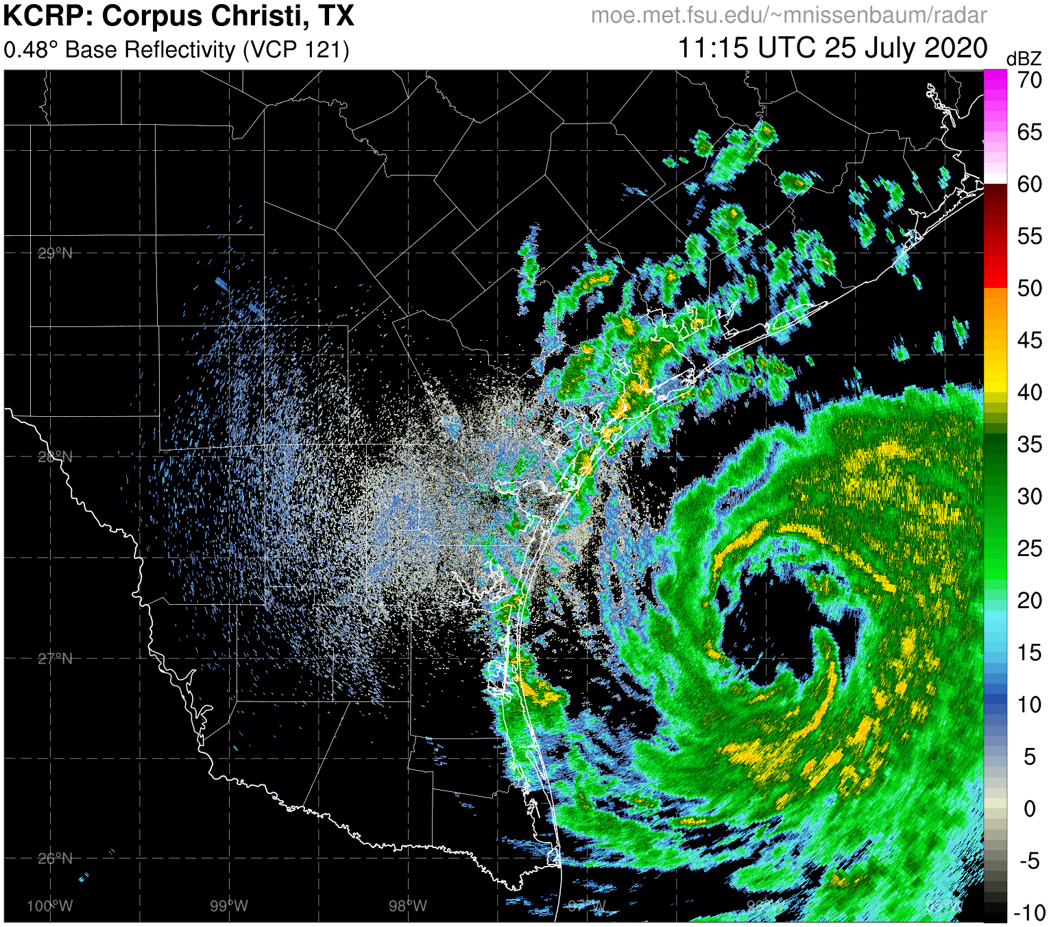
Finally getting something wrapping around the NW of the center of circulation. Another day and Hanna could/would be Harvey vs Rockport impacts.
Posted on 7/24/20 at 9:50 pm to slackster
...NOAA HURRICANE HUNTERS INDICATE THAT HANNA IS STRENGTHENING... ...EXPECTED TO MAKE LANDFALL AS A HURRICANE TOMORROW IN SOUTHERN TEXAS...
10:00 PM CDT Fri Jul 24
Location: 27.1°N 94.8°W
Moving: W at 8 mph
Min pressure: 992 mb
Max sustained: 65 mph
10:00 PM CDT Fri Jul 24
Location: 27.1°N 94.8°W
Moving: W at 8 mph
Min pressure: 992 mb
Max sustained: 65 mph

Posted on 7/24/20 at 9:54 pm to Roll Tide Ravens
Those are some really cold cloud tops almost wrapped all the way around the circulation for a tropical storm. Hell even a Cat 1 hurricane.
Posted on 7/24/20 at 9:57 pm to The Boat
quote:
Those are some really cold cloud tops almost wrapped all the way around the circulation for a tropical storm. Hell even a Cat 1 hurricane.
quote:
The Boat
You know Hanna looks legit when The Boat makes a comment like this. As far as I can tell, this is the only named storm of the season he's acknowledged as such.
Posted on 7/24/20 at 9:58 pm to The Boat
quote:
Those are some really cold cloud tops almost wrapped all the way around the circulation for a tropical storm. Hell even a Cat 1 hurricane.
Once that west side fully closes off, giddy up.
Posted on 7/24/20 at 10:00 pm to slackster
Yeah nothing grinds my gears more than what I call wasted name storms. When they call something a tropical storm when it’s out in the Atlantic and heading out to sea by the time they name it. Or like that 12 hour storm in South Carolina. We’ve had a lot of names so far but it’s like they’ve been stuffing the ballot box so far. Hurricane Hanna is finally something to pay attention to.
Posted on 7/24/20 at 10:03 pm to The Boat
Record # of names for the date.
ACE is average for the date.
ACE is average for the date.
Posted on 7/24/20 at 10:04 pm to The Boat
quote:
Yeah nothing grinds my gears more than what I call wasted name storms. When they call something a tropical storm when it’s out in the Atlantic and heading out to sea by the time they name it. Or like that 12 hour storm in South Carolina. We’ve had a lot of names so far but it’s like they’ve been stuffing the ballot box so far.
As I said earlier in the thread, 2020 is slightly higher than middle of the road with respect to total cyclone energy, yet it's the earlier we've ever had a G storm, much less an H.
Posted on 7/24/20 at 10:07 pm to slackster
In 2005 we had 3 hurricanes by this point including a cat 4 and 5. Let’s see if August cranks up the intensity.
Posted on 7/24/20 at 10:07 pm to slackster

The outflow on this thing is excellent for the Atlantic basin.

Posted on 7/24/20 at 10:09 pm to Duke

Posted on 7/24/20 at 10:47 pm to Bobby OG Johnson
It’s gonna be a Cat 2 at landfall, only good thing about the situation is there’s not much between Corpis and Brownsville..........

Posted on 7/24/20 at 11:07 pm to LSUfonte
quote:
We are down in Mexico
Pretty sure the hurricane is the least of your worries.

Posted on 7/25/20 at 4:28 am to LSUJuice
TS Hannah
4:00 AM CDT Sat Jul 25
Location: 27.0°N 95.8°W
Moving: W at 9 mph
Min pressure: 988 mb
Max sustained: 70 mph
4:00 AM CDT Sat Jul 25
Location: 27.0°N 95.8°W
Moving: W at 9 mph
Min pressure: 988 mb
Max sustained: 70 mph
This post was edited on 7/25/20 at 4:28 am

Posted on 7/25/20 at 5:09 am to NorthEndZone
quote:
This anemometer is about 390 feet above the surface, but winds are really ramping up to nearly hurricane force gusts. It is about 40 miles NNE of the center right now.


Posted on 7/25/20 at 5:51 am to dhuck20
An anemometer is a device that measures wind speed and pressure. You see meteorologists holding the little yellow ones on TV all the time. This one Happens to be 390 feet in the air on top of an oil rig (designated KEMK) in the gulf. Hannah passed and rig was 40 miles NNE of the eye of Hannah. It is measuring near hurricane sustained winds in knots (left side) and designated by the blue line on the graph. This one does not have the air pressure line on it, but typically both green and blue lines are on the same graph, so you can easily see a correlation between the wind speed and air pressure at the same point in time. The red line here shows the wind gusts.
1 knot = about 1.15mph
So it’s showing 56 knots or roughly 64mph winds 40 miles from the eye when it passed the rig
1 knot = about 1.15mph
So it’s showing 56 knots or roughly 64mph winds 40 miles from the eye when it passed the rig
This post was edited on 7/25/20 at 6:20 am
Posted on 7/25/20 at 6:40 am to IT_Dawg

 Page 17 of 50

Popular
Back to top