- My Forums
- Tiger Rant
- LSU Recruiting
- SEC Rant
- Saints Talk
- Pelicans Talk
- More Sports Board
- Winter Olympics
- Fantasy Sports
- Golf Board
- Soccer Board
- O-T Lounge
- Tech Board
- Home/Garden Board
- Outdoor Board
- Health/Fitness Board
- Movie/TV Board
- Book Board
- Music Board
- Political Talk
- Money Talk
- Fark Board
- Gaming Board
- Travel Board
- Food/Drink Board
- Ticket Exchange
- TD Help Board
Customize My Forums- View All Forums
- Show Left Links
- Topic Sort Options
- Trending Topics
- Recent Topics
- Active Topics
Started By
Message

 0
0


Posted on 10/23/20 at 8:41 am to rds dc


Posted on 10/23/20 at 8:51 am to Cosmo
Sooooo do we have to worry/plan on something
Or
Will we finally get some cool weather that will save us?
Or
Will we finally get some cool weather that will save us?
Posted on 10/23/20 at 8:55 am to longhorn22
Im seeing a depression into the panhandle sometime around 10/29. Let’s just hope it stays east and weak
Posted on 10/23/20 at 9:02 am to longhorn22
Cold front coming middle of next week. Should protect LA. But who knows
Posted on 10/23/20 at 9:23 am to Cosmo
What does this mean for Nola?
Posted on 10/23/20 at 9:27 am to Cosmo
quote:
Philippe Papin joins NHC and his first report is this shite
Papin comin' in hot

Posted on 10/23/20 at 9:45 am to rt3
This is wild. A fish storm and a depression into FL and this thread is already one of the longest in TD history.

Posted on 10/23/20 at 9:48 am to theOG
Meteorologist Nick Mikulas

quote:
I see you out there creepin around my page. Someone has definitely posted the image of the 60% chance for a tropical system to develop, and I’m sure that sent you into a frenzy. Will this poor man have to serenade us like he does the interior of his car every day? Pro tip, wearing a mask while driving is a good way to avoid that awkward moment when you are really feeling that last power moment in Phil Collins’ Against All Odds. But no, I *should* be safe from the horror of subjecting you to any sort of attempt at singing, and here’s why. While this thing could absolutely become a tropical storm in the next couple days, a big upper feature will slide our way in four or five days. Sometimes I’ll talk about wind shear being a problem when it’s at 20-30 knots. That’s actually pretty strong when it comes to a tropical system. This upper low will be packing a solid 90-120 knots over our area. That trough may be able to draw some of the moisture in from whatever Greek letter this becomes, and bring us a boost to our rain chances. Any sort of significant tropical issues should stay confined to Cuba and perhaps Florida. It’s not impossible that there would be a hurricane out that way. Fortunately, the waters of the Gulf of Mexico are cooling, and wind shear will be a factor. Also, this upper system is so strong, and packed with cold air, that it will likely snow in the Texas panhandle in a few days. A good rule of thumb when forecasting Gulf hurricanes is that if it’s snowing in Amarillo, we are typically safe from a hurricane. That being said, I’m never bold enough to turn my back on this tropical season. I envision me nervously posting about some rogue ball of thunderstorms at whatever New Years Eve party I attend. Top contenders for that party are currently my couch, or back porch. The guest list is currently 2, but we might expand it to allow one or both children.
The bottom line, every bit of meteorological knowledge and common sense says this won’t be a problem for us. So stay tuned I guess?
Posted on 10/23/20 at 9:49 am to rds dc

Posted on 10/23/20 at 9:54 am to Cosmo
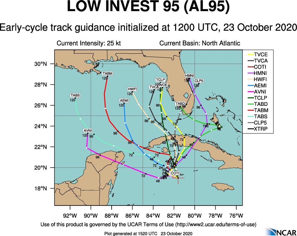
GFS and CMC not as optimistic as ICON about development


Posted on 10/23/20 at 12:47 pm to longhorn22
Well, right now it's forecast for a cold front to move through middle of the week. This is more of a Florida problem right now. You never know though these damn cold fronts sometimes don't dip hard like they project this far out.
That little tropical storm that hit us around the Auburn game around October last year fricked the Northshore up. That thing hit harder than all of Barry combined last year.
That little tropical storm that hit us around the Auburn game around October last year fricked the Northshore up. That thing hit harder than all of Barry combined last year.
This post was edited on 10/23/20 at 12:49 pm
Posted on 10/23/20 at 12:57 pm to Hat Tricks
quote:
A good rule of thumb when forecasting Gulf hurricanes is that if it’s snowing in Amarillo, we are typically safe from a hurricane.
the more you know
I like this rule of thumb
Posted on 10/23/20 at 1:01 pm to Clockwatcher68
quote:
CMC
Another rule of thumb:
Never trust the Canadians when tropical weather is concerned.

Posted on 10/23/20 at 1:09 pm to Cosmo
Good old fashioned anywhere model spread

Posted on 10/23/20 at 1:11 pm to The Boat


Posted on 10/23/20 at 1:24 pm to deuce985
quote:
That little tropical storm that hit us around the Auburn game around October last year fricked the Northshore up.
Yep. It was a doozy
Posted on 10/23/20 at 1:35 pm to LegendInMyMind
Duke, currently nocturnal because his idiot baby is also nocturnal, wakes up and checks the weather:

Ok. So it's late October, this thing has to get a kick out or at least get it's head cut off on an approach. Right?

Ok. This is promising, that's a stout upper low and sitting with the pretty neutral tilt. That would keep rolling due east and is already doing enough to get the steering starting to turn things east by Wednesday. This is the Euro that likes to keep the eastern ridge cooked in strong.

GFS is on board, just a little bit faster, per tradition. That's hostile AF for anything wanting to approach Louisiana. Development would appear to be kicked out NE.

That's pretty fricking hostile over the western Gulf by Wednesday.

Make it the entire Gulf.
HMON brings it across Cuba, through Miami as a TS/weak Cane. Then back into the eastern Gulf as a TD and back inland to Florida and rolling out east.
Overall, looks like a Florida problem and the Gulf is going to be awfully uninviting for a tropical system. That's a strong signal for that trough, and I doubt it just doesn't materialize.
Ok. So it's late October, this thing has to get a kick out or at least get it's head cut off on an approach. Right?
Ok. This is promising, that's a stout upper low and sitting with the pretty neutral tilt. That would keep rolling due east and is already doing enough to get the steering starting to turn things east by Wednesday. This is the Euro that likes to keep the eastern ridge cooked in strong.
GFS is on board, just a little bit faster, per tradition. That's hostile AF for anything wanting to approach Louisiana. Development would appear to be kicked out NE.
That's pretty fricking hostile over the western Gulf by Wednesday.
Make it the entire Gulf.
HMON brings it across Cuba, through Miami as a TS/weak Cane. Then back into the eastern Gulf as a TD and back inland to Florida and rolling out east.
Overall, looks like a Florida problem and the Gulf is going to be awfully uninviting for a tropical system. That's a strong signal for that trough, and I doubt it just doesn't materialize.
Posted on 10/23/20 at 1:41 pm to Duke
Gulf of Mexico is closed for business

 Page 16 of 228

Popular
Back to top