- My Forums
- Tiger Rant
- LSU Recruiting
- SEC Rant
- Saints Talk
- Pelicans Talk
- More Sports Board
- Winter Olympics
- Fantasy Sports
- Golf Board
- Soccer Board
- O-T Lounge
- Tech Board
- Home/Garden Board
- Outdoor Board
- Health/Fitness Board
- Movie/TV Board
- Book Board
- Music Board
- Political Talk
- Money Talk
- Fark Board
- Gaming Board
- Travel Board
- Food/Drink Board
- Ticket Exchange
- TD Help Board
Customize My Forums- View All Forums
- Show Left Links
- Topic Sort Options
- Trending Topics
- Recent Topics
- Active Topics
Started By
Message

 1
1

Posted on 5/21/18 at 8:53 am to LSUfanNkaty
Euro model has it in the Gulf. GFS has it in Atlantic. 7 day forecasts are widely inaccurate.
Posted on 5/21/18 at 8:54 am to Jim Rockford
It fricking better still be there.

Posted on 5/21/18 at 8:54 am to rds dc
Posted on 5/21/18 at 9:00 am to tke857
Need something to cool off temps and slow down killings in Baton Rouge. This past weekend was bad again.
Posted on 5/21/18 at 9:34 am to tke857
I refuse to show the Euro runs to my parents who flooded during Harvey. They would probably go into full on panic mode. I am thinking the GFS may be right on this one, the shear should move this more east. This is what happened with Debby a few years back. The GFS was the only one to get that one right.

Posted on 5/21/18 at 9:43 am to BigB0882
quote:
I refuse to show the Euro runs to my parents who flooded during Harvey. They would probably go into full on panic mode. I am thinking the GFS may be right on this one, the shear should move this more east. This is what happened with Debby a few years back. The GFS was the only one to get that one right
I will panic until RDS tells me not to.... Or until PJ says we need to panic.
Posted on 5/21/18 at 9:44 am to LSUDAN1
quote:
Need something to cool off temps and slow down killings in Baton Rouge. This past weekend was bad again.
This would be like using a flamethrower to kill a spider.
Posted on 5/21/18 at 10:02 am to BigB0882
Giddy up
Posted on 5/21/18 at 10:56 am to BigB0882
quote:
I am thinking the GFS may be right on this one, the shear should move this more east. This is what happened with Debby a few years back. The GFS was the only one to get that one right.
The only problem with that is that the GFS and Euro aren't on the same levels as they were back in '12. I'm not saying the Euro will be right this time but it is hard to make an argument based on the models from nearly 6 years ago.
On the overnight models, the GFS/FV3-GFS and Euro are pretty similar through 48 hrs until you get into the upper levels. The GFS/FV3-GFS have stronger flow above 300mb across the Southern Gulf vs the Euro. That translate to stronger shear and it also plays a role in how convection develops. They all have an upper low sitting out West with flow splitting into a southern and northern branch. That indicates that we should know here in the next 24 hrs which model is going to be right on that portion of the setup. Stronger flow across the Gulf will produce higher shear and could favor convection building off to the NE. Relaxed flow results in less shear and a chance for a system to build into the Central Gulf.
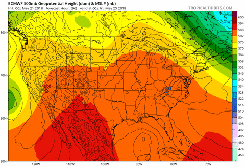
Quality upper level maps aren't freely available for all the models, so below is 500mb anomaly with red lines indicating 250mb flow.
00z GFS

00z FV3-GFS

00z Euro

Over the next day or so we will see convection increase across the Yucatan Channel and then either spread NE across Florida or up into the Gulf.

This post was edited on 5/21/18 at 11:00 am
Posted on 5/21/18 at 11:04 am to rds dc
I don't know what any of that means, so I'll just hold my hand on the panic button for now.
Posted on 5/21/18 at 11:11 am to oOoLsUtIgErSoOo
quote:
I don't know what any of that means, so I'll just hold my hand on the panic button for now.
No need to even have the panic button out at this point. The models struggle with this kind of setup, so just something to keep an eye on. The GFS has been trending westward but it is also slower to develop. Timing appears to be key, with the Euro slipping into the Central Gulf pretty quickly while shear is a bit more relaxed.
Posted on 5/21/18 at 12:33 pm to rds dc
12z models for next Saturday night (FV3-GFS running, Euro about to run)
GFS

ICON

CMC

ETA:
FV3-GFS does some funky stuff before consolidating a low near the mouth of the River, it then drifts SW into the Gulf

GFS
ICON
CMC
ETA:
FV3-GFS does some funky stuff before consolidating a low near the mouth of the River, it then drifts SW into the Gulf
This post was edited on 5/21/18 at 1:13 pm
Posted on 5/21/18 at 12:38 pm to rds dc
Soooooo, GFS has come around to Euro?
Posted on 5/21/18 at 12:40 pm to LSUsmartass
quote:
Soooooo, GFS has come around to Euro?
Not exactly but did trend a little west earlier. I think the current GFS far to the east is picking up on convection being blown way off to the East and taking that as the primary low pressure as far as I can tell.

Posted on 5/21/18 at 12:41 pm to rds dc
Flying out of MSY Friday night. Will the blob make it there by friday night?
Posted on 5/21/18 at 12:45 pm to LSUDAN1
quote:
slow down killings in Baton Rouge.
Well, wasn't it a hurricane (Katrina) that brought an influx of criminals from NO that BR is still reeling from every day?
Posted on 5/21/18 at 12:46 pm to Duke
Over a month with no rain. Hope to get something out of this
Posted on 5/21/18 at 12:47 pm to East Coast Band
Get this crap out of this thread
Posted on 5/21/18 at 1:03 pm to Duke
So basically what I am seeing is the opening day of snapper season if royally fricked. Correct?

 Page 6 of 57

Popular
Back to top