- My Forums
- Tiger Rant
- LSU Recruiting
- SEC Rant
- Saints Talk
- Pelicans Talk
- More Sports Board
- Winter Olympics
- Fantasy Sports
- Golf Board
- Soccer Board
- O-T Lounge
- Tech Board
- Home/Garden Board
- Outdoor Board
- Health/Fitness Board
- Movie/TV Board
- Book Board
- Music Board
- Political Talk
- Money Talk
- Fark Board
- Gaming Board
- Travel Board
- Food/Drink Board
- Ticket Exchange
- TD Help Board
Customize My Forums- View All Forums
- Show Left Links
- Topic Sort Options
- Trending Topics
- Recent Topics
- Active Topics
Started By
Message
 1
1

Posted on 7/1/24 at 9:36 am to NorthEndZone
UPDATED --- Carriacou Island is right in the middle of the eye.
Stream down now but they will be in the eye. Unfortunately for Carriacou and Grenada itself, eyewall replacement cycle timing was worst case for them.

Stream down now but they will be in the eye. Unfortunately for Carriacou and Grenada itself, eyewall replacement cycle timing was worst case for them.
This post was edited on 7/1/24 at 10:17 am
Posted on 7/1/24 at 9:44 am to mightynine
This post was edited on 7/1/24 at 9:45 am

Posted on 7/1/24 at 10:15 am to Zapps4Life
Carriacou is squarely in the eye now.

Posted on 7/1/24 at 10:16 am to Roll Tide Ravens
Landfall is official. Max sustained winds are up to 150 mph now!
Hurricane Beryl Tropical Cyclone Update
NWS National Hurricane Center Miami FL AL022024
1110 AM AST Mon Jul 1 2024
...EXTREMELY DANGEROUS CATEGORY 4 BERYL MAKES LANDFALL ON CARRIACOU
ISLAND...
...AIR FORCE RECONNAISSANCE AIRCRAFT FINDS BERYL STRONGER...
Satellite imagery and Barbados radar data indicate that the eye of
Beryl has made landfall on Carriacou Island at 1110 AM AST (1510
UTC). Data from an Air Force Reserve Hurricane Hunter aircraft
indicate that Beryl's maximum sustained winds have increased to 150
mph (240 km/h). The latest minimum central pressure estimated from
reconnaissance data is 950 mb (28.05 inches).
SUMMARY OF 1110 AM AST...1510 UTC...INFORMATION
-----------------------------------------------
LOCATION...12.5N 61.5W
ABOUT 0 MI...0 KM S OF CARRIACOU ISLAND
ABOUT 30 MI...50 KM NNE OF GRENADA
MAXIMUM SUSTAINED WINDS...150 MPH...240 KM/H
PRESENT MOVEMENT...WNW OR 285 DEGREES AT 20 MPH...31 KM/H
MINIMUM CENTRAL PRESSURE...950 MB...28.05 INCHES

Posted on 7/1/24 at 10:21 am to Cosmo
quote:
No CNN mention of the Hunga Tonga volcano eruption which is why global temperatures have been 1-2° warmer the last couple years? Should normalize over next couple years.
I thought (hoped) this would bring a bit of a drought in the upper gulf coast this summer again, although not as severe as last year. That high pressure dome seemed to keep the hurricanes away.
Not that I want forest fires or 105 degree weather again. But I'd take that over a major American city being nailed by a Cat 3 (or bigger) storm.
Posted on 7/1/24 at 10:21 am to Roll Tide Ravens
Roll Tide Ravens (I like your zoomed images)
Crazy how a 12 square mile island got the full eye.
Crazy how a 12 square mile island got the full eye.
Posted on 7/1/24 at 10:21 am to Roll Tide Ravens
Posted on 7/1/24 at 10:26 am to Roll Tide Ravens
quote:
Carriacou is squarely in the eye now.
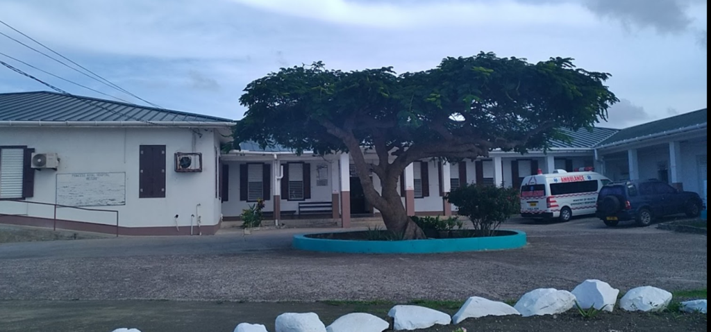
That is a tiny island of 8,000 people. Doesn't look like the construction quality is super impressive based on the photos.
Their hospital looks to be a good 1,000 feet up the mountain and fairly low slung. Looks well constructed compared to the rest of that island's buildings, but I doubt this thing can handle 150 mph winds.
This post was edited on 7/1/24 at 10:30 am

Posted on 7/1/24 at 10:30 am to Roll Tide Ravens
quote:
Carriacou is squarely in the eye now.
You could not draw up a direct hit on this tiny island any better than this...goodness...those residents
Posted on 7/1/24 at 10:35 am to Roll Tide Ravens
Posted on 7/1/24 at 10:35 am to Roll Tide Ravens
quote:
Carriacou is squarely in the eye now.
That's a direct hit. My goodness.

Posted on 7/1/24 at 10:35 am to LaBR4
When I lived in the Caribbean for school we got hit by a tropical storm and I remember how bad it was thereafter, I can't imagine a Cat 4 hitting out island.
Posted on 7/1/24 at 10:49 am to jose
Is that different than the country that always goes to the LLWS? It looks like maybe it's spelled different.
Posted on 7/1/24 at 10:50 am to NorthEndZone
quote:
Unfortunately for Carriacou and Grenada itself, eyewall replacement cycle timing was worst case for them.
Barrel overachieved in strengthening and overachieved in getting through and completing the EWRC quickly. I was hoping last night that it would help spare the islands a bit.
Posted on 7/1/24 at 10:55 am to OysterPoBoy
quote:
Is that different than the country that always goes to the LLWS? It looks like maybe it's spelled different.
Yes. You are thinking of Curaçao. At first I was thinking the same as well.
Posted on 7/1/24 at 10:57 am to OysterPoBoy
quote:
Is that different than the country that always goes to the LLWS? It looks like maybe it's spelled different.
Yes.
Curaçao is one of the ABC island. Aruba, Bonaire and Curaçao which re located just north of Venezuela.
I wasn't living on any of these, if that was part of your question
Posted on 7/1/24 at 11:00 am to jmorr34
quote:
Yes. You are thinking of Curaçao. At first I was thinking the same as well.
I was thinking the same, too.
Posted on 7/1/24 at 11:04 am to Roll Tide Ravens
quote:
MAXIMUM SUSTAINED WINDS...150 MPH...240 KM/H
So most parts of the US would have severe, catastrophic damage if they had to deal with 150 mph sustained winds. That's excluding the storm surge which is likely massive for this storm.
Paraphrasing what I found from TWC from about 20 years ago, and it's centered around American building practices:
70-90 mph sustained - Extensive tree damage, power outages; homes near large trees at risk for major damage. Garage doors will blow out of their tracks, power lines will go down, and debris/wind will make safe transportation near impossible. This is no joke, especially in an urban area with a lot of debris.
90-100 mph sustained - A fairly new roof on a typical residential home will lose some shingles, gutters, and ridge caps. Livestock needs to be sheltered. Emergency vehicles likely not operating safely in this. Mobile Homes would have severe damage.
100-110 mph sustained - substantial portions of the asphalt shingle coverage will be blown away. Smaller debris impacting windows, doors. Most mobile homes would be destroyed. This would be extremely dangerous for unsheltered livestock. If 100mph sustained is predicted- even the most stubborn among us really need to consider evacuating unless they are in a large commercial building.
110-130 mph sustained - Roof decking damaged, severe leaks, some windows/doors blown out. Interior rooms would need to serve as shelter for extended period of time. Some older homes with tongue/grove roof decking or newer structures with sheer walls/hurricane straps may avoid total destruction, but most homes will have extensive damage. If this is predicted in your area, you need to evacuate.
130 mph + sustained - Typical residential homes are simply not built to handle this kind of force for any period of time. Most suburban retail/offices will experience sever damage or even full destruction. This is what south Florida experienced in 1992 with Hurricane Andrew and drove a major rework of their building codes. Do not be where there is this kind of wind.
I imagine the construction quality in Grenada is nowhere near what we see in most of the US. And they are getting 150mph sustained winds.
This post was edited on 7/1/24 at 11:07 am
Posted on 7/1/24 at 11:04 am to jose
I wonder if that ole baw took our advice and left Jamaica

 Page 20 of 218

Popular
Back to top