- My Forums
- Tiger Rant
- LSU Recruiting
- SEC Rant
- Saints Talk
- Pelicans Talk
- More Sports Board
- Winter Olympics
- Fantasy Sports
- Golf Board
- Soccer Board
- O-T Lounge
- Tech Board
- Home/Garden Board
- Outdoor Board
- Health/Fitness Board
- Movie/TV Board
- Book Board
- Music Board
- Political Talk
- Money Talk
- Fark Board
- Gaming Board
- Travel Board
- Food/Drink Board
- Ticket Exchange
- TD Help Board
Customize My Forums- View All Forums
- Show Left Links
- Topic Sort Options
- Trending Topics
- Recent Topics
- Active Topics
Started By
Message
re: Deep South Christmas COLD
Posted on 12/19/22 at 1:30 pm to trussthetruzz

Posted on 12/19/22 at 1:30 pm to trussthetruzz
quote:Radiatonal cooling has overperformed. Only 42 here in BR.
Anyone else way below forecast high for today? It’s 36 here in Pike county w/ steady rain. Surely there’s no chance we squeeze out a few flakes, right?
I'd imagine the warm air extends too high for flakes.
Let us know if you seem some!
 3
3

Posted on 12/19/22 at 1:31 pm to bayoubengals88
37 and raining in Tim McGraw country. I don't see any snow as yet.
Posted on 12/19/22 at 1:32 pm to bayoubengals88
Will do. I’m working outside today so I will not miss it
Posted on 12/19/22 at 1:32 pm to Duke
Forgive me - I've just read the last couple of pages....Is this storm brining serious freezing rain/snow/sleet to south MS/LA/AL or not?

Posted on 12/19/22 at 1:36 pm to bayoubengals88
This is evaporative cooling
Temp was 43 with an RH of 76% in BR when it started raining an hour ago. Temp is 39 now and RH is 93%.
Temp was 43 with an RH of 76% in BR when it started raining an hour ago. Temp is 39 now and RH is 93%.
Posted on 12/19/22 at 1:38 pm to RT1941
Seems unlikely from the latest indications
Posted on 12/19/22 at 1:38 pm to The Boat
quote:Confused my terms. Radiational is on a clear night
This is evaporative cooling

Nice stats!
Posted on 12/19/22 at 1:39 pm to bayoubengals88
The air is running out of capacity to hold water so the temp isn't going to cool off much more. And this thick cloud deck isn't going to let any radiational cooling occur tonight so temps are going to pretty much hold steady until tomorrow.
I'd like to see some snow but I digest.
I'd like to see some snow but I digest.
Posted on 12/19/22 at 1:41 pm to The Boat
quote:How high up would we have to go for snow right now?
The air is running out of capacity to hold water so the temp isn't going to cool off much more. And this thick cloud deck isn't going to let any radiational cooling occur tonight so temps are going to pretty much hold steady until tomorrow.
Posted on 12/19/22 at 1:42 pm to The Boat
I’m guessing it’s near impossible to forecast evaporative cooling? Days like today is why i’ll never rule out a chance of snow if conditions are close to being suitable
Posted on 12/19/22 at 1:43 pm to The Boat
quote:
I digest.
Hope it all works out ok. :)
Posted on 12/19/22 at 1:44 pm to trussthetruzz
Always a chance you can wet bulb your arse off
Posted on 12/19/22 at 1:46 pm to bayoubengals88
quote:
How high up would we have to go for snow right now?
About 13000 feet judging by the melting layer on CC around Shreveport. Big melting line from 5400 feet to 13000 feet which line up with this big warm nose on HRRR soundings.


This post was edited on 12/19/22 at 1:52 pm
Posted on 12/19/22 at 1:48 pm to The Boat
quote:
wet bulb your arse off
Careful.
Posted on 12/19/22 at 2:06 pm to The Boat
What is that showing? I'm in the pink there
Posted on 12/19/22 at 2:13 pm to Sao
That's the radar beam from the Shreveport radar. That solid pink close to Shreveport is all rain. The beam is rising as it travels out and once it's to that yellow stuff it's about 5000 feet off the ground. Once it's out of that it's about 13000 feet off the ground. That yellow area is uncorrelated objects so it's snow and ice melting into rain. Above that is all pink again so it's probably all snow. But at that point it's 13000+ feet off the ground and hasn't fallen through the warm layer yet.
Posted on 12/19/22 at 2:15 pm to Jim Rockford
quote:THANK YOU!
Seems unlikely from the latest indications
Travel plans and winterizing the house will continue as planned.
Posted on 12/19/22 at 2:29 pm to Sao
And all of what tBoat said as he digested is backed up by the circled bit of the Skew-t.
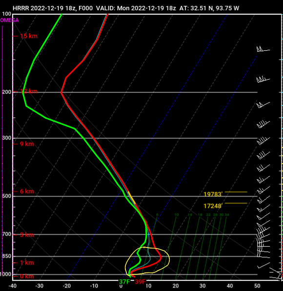
The temps just above ground are well above freezing. Whatever frozen precip forms above melts as it passes through that layer.
The temps just above ground are well above freezing. Whatever frozen precip forms above melts as it passes through that layer.
Posted on 12/19/22 at 2:35 pm to LegendInMyMind
It's cool when you can match the skew-t to the radar. HRRR on the ball.
Another note.. that thin blue line, for lack of a better descriptor, is the wet bulb temperature. Which is what the temperature would be if the air becomes fully saturated from water evaporating as it falls through it at that point. It would cool off some but we'd still have a nice warm nose under our current conditions. Confirming the un-anticipation of snow or any winter precip.
Another note.. that thin blue line, for lack of a better descriptor, is the wet bulb temperature. Which is what the temperature would be if the air becomes fully saturated from water evaporating as it falls through it at that point. It would cool off some but we'd still have a nice warm nose under our current conditions. Confirming the un-anticipation of snow or any winter precip.

Posted on 12/19/22 at 2:47 pm to The Boat


 Page 21 of 62

Popular
Back to top