- My Forums
- Tiger Rant
- LSU Recruiting
- SEC Rant
- Saints Talk
- Pelicans Talk
- More Sports Board
- Winter Olympics
- Fantasy Sports
- Golf Board
- Soccer Board
- O-T Lounge
- Tech Board
- Home/Garden Board
- Outdoor Board
- Health/Fitness Board
- Movie/TV Board
- Book Board
- Music Board
- Political Talk
- Money Talk
- Fark Board
- Gaming Board
- Travel Board
- Food/Drink Board
- Ticket Exchange
- TD Help Board
Customize My Forums- View All Forums
- Show Left Links
- Topic Sort Options
- Trending Topics
- Recent Topics
- Active Topics
Started By
Message
re: Harvey ***Catastrophic Flooding Event***
Posted on 8/30/17 at 4:39 pm to White Roach

Posted on 8/30/17 at 4:39 pm to White Roach
quote:
Message
TS Harvey ***Catastrophic Flooding Event*** by White Roach
quote:
That's off by 10 inches for port author.
It only goes to 3:00am this morning.
Why? What is the stipulation?
 1
1

Posted on 8/30/17 at 4:46 pm to GATORGAR247
quote:
That's off by 10 inches for port author.
It's going off of preliminary stations that report to the NWS. There may be locally higher amounts.
quote:
AT 300 PM CDT...THESE ARE THE MOST RECENT PRELIMINARY RAINFALL AND
WIND REPORTS FROM TROPICAL STORM HARVEY. PLEASE REFER TO NHC FOR
THE LATEST PUBLIC ADVISORIES ON HARVEY.
...SELECTED PRELIMINARY STORM TOTAL RAINFALL IN INCHES FROM 800 PM
CDT THU AUG 24 THROUGH 300 PM CDT WED AUG 30...
...LOUISIANA...
BAYOU CONWAY 22.25
KENNER GULLY AT MARK LEBLEU 18.23
CALCASIEU RVR AT OLD TOWN BA 18.15
W-14 AT JOE SPEARS RD 17.85
W-6 AT WARD LINE ROAD 17.24
MOSS BLUFF 16.70
BELFIELD DITCH AT BELFIELD ROAD 16.37
IOWA 0.9 ESE 16.36
GOLDSMITH CANAL AT GOOS RD 16.02
BAYOU ARSENE AT HECKER ROAD 15.84
GOLDSMITH CANAL AT HWY 171 15.74
LAKE CHARLES 11.5 SSW 15.41
RAGLEY 5.0 SE 15.18
EB L-14 AT IOWA BASEBALL FIELD 14.85
INDIAN BAYOU AT COFFEY ROAD 14.10
TOPSY 4 NNW 14.08
LACASSINE BAYOU AT LORRAIN BRIDGE 13.04
SULPHUR 2.2 E 12.54
BON WIER 2 ENE 12.44
HACKBERRY 5 SSE 12.33
CONTRABAND BAYOU AT 18TH STREET 12.28
WELSH 0.7 W 12.26
W-4 AT NELSON ROAD 12.12
GILLIS 4 WSW 12.11
FORT POLK 11.96
BUXTON CREEK AT DOUGLAS ROAD 11.21
CHOUPIQUE BAYOU AT HWY 90 11.02
LACASSINE NATIONAL 2 ENE 10.55
BAYOU DINDE AT PICARD ST 9.76
LEBLEU SETTLEMENT 2 WNW 9.64
FORKED ISLAND 5 ENE 9.37
BUNDICK CREEK NEAR DE RIDDER 9.26
PECAN ISLAND 2 E 9.14
LAKE CHARLES MUNI ARPT 9.08
NEW IBERIA/ACADIANA 8.92
VERNON - FTS 8.77
LAFAYETTE RGNL ARPT 7.14
NEW ORLEANS/MOISANT 5.88
NEW ORLEANS/LAKEFRONT 5.33
ENGLAND AFB/ALEXANDRIA 4.84
SLIDELL AIRPORT 3.82
BATON ROUGE/RYAN MUNI ARPT 3.17
...TEXAS...
CEDAR BAYOU AT FM 1942 51.88
CLEAR CREEK AT I-45 49.40
DAYTON 0.2 E 49.23
MARYS CREEK AT WINDING ROAD 49.20
BEAUMONT/PORT ARTHUR 47.35
SANTA FE 0.7 S 46.70
PASADENA 4.4 WNW 45.74
HORSEPEN CREEK AT BAY AREA BLVD 45.60
SOUTH HOUSTON 4.0 SSW 44.91
BERRY BAYOU AT FOREST OAKS BLVD 44.80
BERRY BAYOU AT NEVADA 44.44
FRIENDSWOOD 2.5 NNE 44.05
LITTLE VINCE BAYOU AT BURKE RD 43.52
HOUSTON WEATHER FORECAST OFFICE 43.38
LEAGUE CITY 2.7 NE 43.32
WEBSTER 0.4 NW 43.32
LNVA CHEEK CANAL AT DITCH 407 43.11
LITTLE CEDAR BAYOU AT 8TH ST 42.32
ARMAND BAYOU AT GENOA-RED BLUFF RD 42.16
TURKEY CREEK AT FM 1959 42.12
BOONDOCKS RD AT TAYLORS BA 41.86
ARMAND BAYOU AT PASADENA LAKE 41.20
TAYLOR LAKE AT NASA ROAD 1 40.44
MAHAW BAYOU AT ENGLIN RD 37.75
JACINTO CITY 37.60
HUNTING BAYOU AT LOOP 610 EAST 37.00
TELEPSEN 36.60
MAHAW BAYOU AT BRUSH ISLAND ROAD 36.53
FIRST COLONY 4 WSW 36.34
BEAMER DITCH HUGHES RD 36.32
LA PORTE 1 N 36.24
BAYTOWN 2 NW 35.64
MOUNT HOUSTON 35.60
HOUSTON/CLOVER FIELD 33.37
HOUSTON/INTERCONTINENTAL 31.26
KATY 6 NE 31.23
HOUSTON/WILL HOBBY 27.88
HOUSTON/D.W. HOOKS 27.01
GALVESTON/SCHOLES 22.84
COLLEGE STATION 2 SSW 19.64
...SELECTED PEAK WIND GUSTS IN MILES PER HOUR EARLIER IN THE
EVENT...
...TEXAS...
PORT ARANSAS 2 ENE 132
COPANO VILLAGE 1 ENE 125
LAMAR 2 SSW 110
ROCKPORT 1 S 108
TAFT 5 NNE 90
MAGNOLIA BEACH 8 ESE 79
EDNA 73
FLOUR BLUFF 4 ESE 72
ARANSAS PASS 7 SE 71
CLEAR LAKE SHORES 1 WSW 71
BRAZOS 451 70
PALACIOS MUNICIPAL AIRPORT 69
CORPUS CHRISTI NAS 5 SE 65
GANADO 7 S 64
LA WARD 64
BAYOU VISTA 13 E 61
NEW BRAUNFELS MUNICIPAL AIRPORT 58
QUINTANA 1 NE 58
SUGAR LAND MUNICIPAL AIRPORT 58
JONES CREEK 9 SW 55
LA MARQUE 2 E 55
FREEPORT 1 ESE 54
SAN LEON 19 E 54
MISSOURI CITY 1 SE 53
SAN ANTONIO INTL ARPT 53
WEBSTER 53
BERGSTROM INTL AIRPORT 52
GONZALES AIRPORT 52
NASSAU BAY 52
TEXAS CITY 4 ENE 52
Posted on 8/30/17 at 4:47 pm to Kingpenm3
So they could put the graphic in today's newspaper maybe? I'm not sure. I just read the dates and times at the bottom of the graphic.
For Corpus Christi, the rain was done by 3:00am this morning. But based on what I've heard, in Port Arthur after 3:00 this morning, it was still raining like a cow pissing on a flat rock. Their total rainfall is now above ~45". Corpus is probably still at 6 and whatever inches.
For Corpus Christi, the rain was done by 3:00am this morning. But based on what I've heard, in Port Arthur after 3:00 this morning, it was still raining like a cow pissing on a flat rock. Their total rainfall is now above ~45". Corpus is probably still at 6 and whatever inches.

Posted on 8/30/17 at 4:49 pm to White Roach
I fear for Bun B.
Posted on 8/30/17 at 4:51 pm to White Roach
Man, I feel for that deweyville area, they just got their houses back together from the last flood. Any word on how they are making it? Is any of the Toledo bend water going to make it to their area?
Posted on 8/30/17 at 4:53 pm to Kingpenm3
So what's the OT's thoughts on my ability to get a 26 foot travel trailer to a buddy from BTR to Katy this weekend?
Posted on 8/30/17 at 5:00 pm to ntrcptr
Possible. I10 between Houston and lake Charles closed now but could reopen by Friday

Posted on 8/30/17 at 5:02 pm to Kingpenm3
quote:
Man, I feel for that deweyville area, they just got their houses back together from the last flood. Any word on how they are making it? Is any of the Toledo bend water going to make it to their area?
As of right now projected crest is almost 4 feet lower than last springs record flood. Sabine River Authority are metering the flow to keep the level at full poll which is 172.8. They dropped it well below that last spring which caused the record flood and a giant law suit against them.

Posted on 8/30/17 at 5:03 pm to Sentrius
quote:I was standing in a home with 2 inches of water on the Tuesday following the Aug 2016 flood reconnecting a customer's internet service.
Does anyone remember how long it took for BR flood waters to go away?
Because porn, I guess.

Posted on 8/30/17 at 5:21 pm to FCP
They now think Irma will be a hurricane by tomorrow afternoon. Crazy

Posted on 8/30/17 at 5:32 pm to The Bruce
quote:
I10 between Houston and lake Charles closed now but could reopen by Friday
This is VERY BAD......... Talk about stopping traffic.............
Posted on 8/30/17 at 5:33 pm to BayouBengals03
quote:
They now think Irma will be a hurricane by tomorrow afternoon. Crazy
the last GOES16 image just posted in the Irma thread... it looks too good to not be a hurricane now
Posted on 8/30/17 at 5:39 pm to The Bruce
quote:
Possible. I10 between Houston and lake Charles closed now but could reopen by Friday
Think so? Toledo damn opening won't delay that? I've been stuck in Louisiana since Thursday and trying to get back to check on all my stuff. Thinking of going through Shreveport/Dallas then heading south tomorrow
Posted on 8/30/17 at 5:41 pm to BOSCEAUX
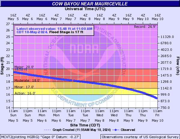
Cow Bayou is between Vidor and Orange. Obliterating the previous record.

Posted on 8/30/17 at 5:41 pm to kciDAtaE
How likely is it that I-49 near Natchitoches will flood?

Posted on 8/30/17 at 5:51 pm to Ellis Dee
quote:
How likely is it that I-49 near Natchitoches will flood?
In general or from Harvey?
Posted on 8/30/17 at 5:53 pm to wickowick
quote:
Steve Bender? @StephenJBender
Most streets in Natchitoches, La look like this after today's rain. #Harvey

Posted on 8/30/17 at 6:04 pm to wickowick
From Harvey
Posted on 8/30/17 at 6:04 pm to Ellis Dee
This rain shouldn't cause any problems to I-49 itself. Anybody going west can probably cross Toledo bend on highway 6 instead of going all the way to 20. Anything south of the lake sounds like it will be out with the release again and I-10 might be a while.
Posted on 8/30/17 at 6:08 pm to TigerDog83

 Page 607 of 618

Popular
Back to top