- My Forums
- Tiger Rant
- LSU Recruiting
- SEC Rant
- Saints Talk
- Pelicans Talk
- More Sports Board
- Winter Olympics
- Fantasy Sports
- Golf Board
- Soccer Board
- O-T Lounge
- Tech Board
- Home/Garden Board
- Outdoor Board
- Health/Fitness Board
- Movie/TV Board
- Book Board
- Music Board
- Political Talk
- Money Talk
- Fark Board
- Gaming Board
- Travel Board
- Food/Drink Board
- Ticket Exchange
- TD Help Board
Customize My Forums- View All Forums
- Show Left Links
- Topic Sort Options
- Trending Topics
- Recent Topics
- Active Topics
Started By
Message

 0
0


Posted on 9/4/19 at 11:33 am to MrLarson
it just might be enough lol
Posted on 9/4/19 at 11:38 am to EventHorizon


Posted on 9/4/19 at 11:44 am to cgrand
When you have a big oceangoing boat like some of those blows my mind you dont just take off for fair weather
Posted on 9/4/19 at 11:45 am to Duke
quote:
Current forecast for Charleston Harbor. This is higher than both Irma and Matthew. It is forecast assuming the NHC path, so any western deviations would see the level a little higher still. All the Charleston posters should keep a close eye on the forecast and readings from this gauge.
Highest water I saw living in Charleston in my neighborhood was for Irma (high tide) and still had quite a few feet to go to make me really nervous about my house. Here's to hoping there is still wiggle room to keep everything dry.
Posted on 9/4/19 at 11:53 am to cgrand
Posted on 9/4/19 at 11:59 am to rds dc
If this thing would have been 20 miles closer inland we would have had it pretty rough . Florida lucked out on this Matthew was much wors
Posted on 9/4/19 at 12:00 pm to Duke

10.3 storm surge would devastate downtown Charleston which sits on average at 8 feet.
This post was edited on 9/4/19 at 12:01 pm
Posted on 9/4/19 at 12:02 pm to metallica81788
quote:
Highest water I saw living in Charleston in my neighborhood was for Irma (high tide) and still had quite a few feet to go to make me really nervous about my house. Here's to hoping there is still wiggle room to keep everything dry.
If you had feet to go, you'll most likely be fine. Only issue would be for Dorian to actually have the center go inland just south of Charleston, which isn't very likely imh(and not professional)o.

Posted on 9/4/19 at 12:04 pm to Centinel
quote:
Oh I'm not worried. I was just pointing out how one small shift had us going from light wind/no rain to close to TS-force winds and lots of rain. I don't remember any of the others storms the past few years having that sharp of a differentiation between getting nothing and experiencing heavy rain/wind.
That’s how hurricanes work. The bad damage and destruction from wind occurs in a little sliver of the eye wall. Areas around get pretty bad weather. But the complete destruction happens in that few miles of eye wall.
When they tell you a hurricane has 145 mph winds it means there’s a narrow few mile band of 145 winds in the eye wall. 145 mph winds aren’t extending the expanse of the storm.
Storm surge is different and anyone on the right front side is susceptible to it.

Posted on 9/4/19 at 12:08 pm to MrLSU
That would be the 2nd highest tide ever recorded in Charleston, just under Hurricane Hugo.
Posted on 9/4/19 at 12:11 pm to Cosmo
quote:
When you have a big oceangoing boat like some of those blows my mind you dont just take off for fair weather
most if not all of those boats are not owned by bahamians. they are owned by americans who live in florida

Posted on 9/4/19 at 12:17 pm to Duke
Looks like Dorian is getting better organised. 
This post was edited on 9/4/19 at 12:35 pm
Posted on 9/4/19 at 12:47 pm to GEAUXT
quote:
Why in the world would he have DC 3s?
He built a couple of resorts on some inhabited island in the Bahamas, he also flew a shite ton of supplies to Haiti and Puerto Rico
Posted on 9/4/19 at 12:53 pm to loogaroo
quote:
Looks like Dorian is getting better organised.
Yes, but not likely to yield much increase in wind speed. I'd expect the wind speed to hold mostly steady. Big storms tend to be pretty steady. They are more stable spread out, so it takes a lot of time and energy to tighten them up more.
Looking at the 12z models:
GFS: Just offshore until barely hitting the OBX. It does bring the western core onshore from Charleston to the barrier islands of NC.
UKMet: West of GFS. Possible landfall at Charleston, Wilmington, and a pretty direct strike at Morehead City.
HWRF and HMON: Farther west of both, with a landfall in Charleston, Wilmington and goes inland from there putting Morehead City and the OBX on the east side. These aren't exceptional on track, but worth noting this is a potential outcome.
Everyone along the coast in the Carolinas should prepare like an HWRF scenario will play out. Would bring higher surge, rain, and wind into coastal communities.
Flooding is a concern from the SC/GA line north. 0z Euro puts over a foot of rain inland south of Charleston. Not very far inland, but it's there.
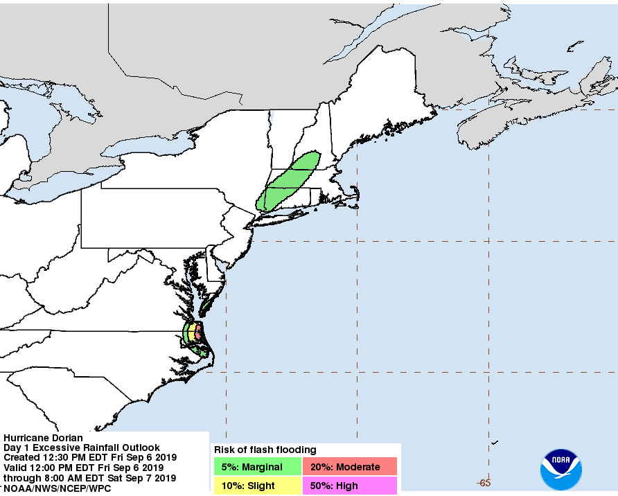
Surge estimates are up to six feet from SC/GA line to the OBX.

West side of Dorian has very heavy rainfall and in total Dorian is more organized than it's been since it started moving away from the Bahamas.
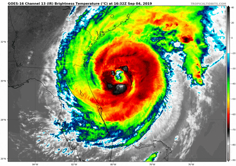
Had some very deep convection going earlier but even now getting a nice ring of black trying to wrap up around the center.
Posted on 9/4/19 at 1:00 pm to cgrand
quote:
most if not all of those boats are not owned by bahamians. they are owned by americans who live all over the US
FIFY
Posted on 9/4/19 at 1:39 pm to tgrbaitn08
You don't see this too often...

This post was edited on 9/4/19 at 1:48 pm
Posted on 9/4/19 at 1:40 pm to tgrbaitn08
Off to forecasting class. Keep my seat warm while I’m out.
Posted on 9/4/19 at 1:52 pm to loogaroo
12z Euro drops Dorian down to the 940s along the Carolina coast. Seems overdone, but conditions are going to be quite good until the turn off NC.
There were also some stout gusts shown. Near 80 kts in Charleston (92 mph) and even over 90 kts on the outer banks. Wouldn't make a wind forecast based on one model that probably has the pressure a little too low. Just noting the potential.
There were also some stout gusts shown. Near 80 kts in Charleston (92 mph) and even over 90 kts on the outer banks. Wouldn't make a wind forecast based on one model that probably has the pressure a little too low. Just noting the potential.
Posted on 9/4/19 at 1:57 pm to cgrand
That pic reminds me of Southshore Harbor after Katrina..
Four boats survived, one happened to be a friend of mine's..
Four boats survived, one happened to be a friend of mine's..

 Page 241 of 263

Popular
Back to top