- My Forums
- Tiger Rant
- LSU Recruiting
- SEC Rant
- Saints Talk
- Pelicans Talk
- More Sports Board
- Winter Olympics
- Fantasy Sports
- Golf Board
- Soccer Board
- O-T Lounge
- Tech Board
- Home/Garden Board
- Outdoor Board
- Health/Fitness Board
- Movie/TV Board
- Book Board
- Music Board
- Political Talk
- Money Talk
- Fark Board
- Gaming Board
- Travel Board
- Food/Drink Board
- Ticket Exchange
- TD Help Board
Customize My Forums- View All Forums
- Show Left Links
- Topic Sort Options
- Trending Topics
- Recent Topics
- Active Topics
Started By
Message

 1
1

Posted on 9/1/18 at 11:10 am to PhillyTiger90
quote:
Gordon would be the name if this thing organizes.
Get Gordon Get it done
Posted on 9/1/18 at 11:14 am to rds dc
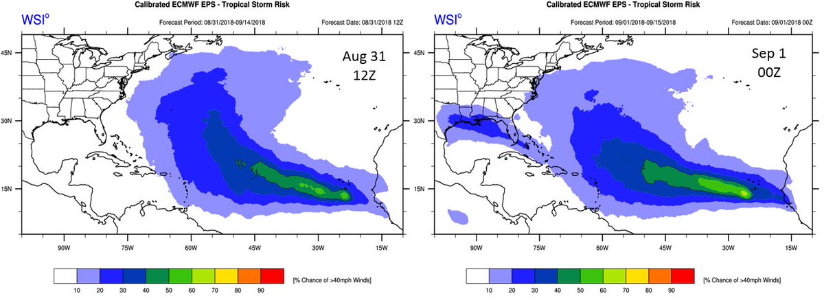
Last two Euro EPS runs. Can see the westward shift and the increase in chances for a Gulf storm.
Posted on 9/1/18 at 11:26 am to rds dc
Amazing how quiet it is then the high point hits us and all of a sudden it just takes 1 eh? You would think we'd get a break after last year.
Posted on 9/1/18 at 12:04 pm to rds dc
Is that 8/31 12Z run not even showing the storm? And the Sep 1 0Z run is now showing it?

Posted on 9/1/18 at 12:10 pm to deuce985
quote:
is the forecast
quote:
anything can happen
quote:
I think
quote:
it could
quote:
I think
quote:
(if anything)
quote:
maybe
quote:
I just hope
I'm worried now.
Posted on 9/1/18 at 12:20 pm to 91TIGER
Models been consistent on it being a weak storm and going on the westward track. Florence already shifted west more on their track in a day from a fish storm. Common sense people. How many times do you have to go through hurricane season to know it's impossible to predict a storm 5-7 days out?
3 consistencies I've noticed on the computer models past few days.
-westward movement in the Gulf
-weak storm by the time it hits land
-each forecast is slightly worse for the impacts while gaining a little more strength
Nothing to get worried about right now just keep your eye on it.
3 consistencies I've noticed on the computer models past few days.
-westward movement in the Gulf
-weak storm by the time it hits land
-each forecast is slightly worse for the impacts while gaining a little more strength
Nothing to get worried about right now just keep your eye on it.
Posted on 9/1/18 at 1:24 pm to deuce985
Lafourche parish hit on new Euro. 993mb.
Posted on 9/1/18 at 1:31 pm to Zach Lee To Amp Hill
Euro on Wednesday morning...

Posted on 9/1/18 at 1:31 pm to Zach Lee To Amp Hill
quote:
Lafourche parish hit on new Euro. 993mb.
The Euro shows rapidly improving upper level environment as the storm approaches. There is a 6 hr drop from 1001mb to 993mb right before landfall. If that improvement happens 12 hrs sooner then there is a real chance for RI to a significant storm right at landfall.

It gets down to 993mb in between these two frames.


Posted on 9/1/18 at 1:32 pm to rds dc
what day about would this be?
eta: saw wed morning
eta: saw wed morning
This post was edited on 9/1/18 at 1:33 pm
Posted on 9/1/18 at 1:33 pm to LaBR4
Wednesday
Posted on 9/1/18 at 1:34 pm to rds dc
I know it's coming but I am a little surprised the NHC has not classified this as an Invest yet.
Posted on 9/1/18 at 1:43 pm to rds dc
quote:
If that improvement happens 12 hrs sooner then there is a real chance for RI to a significant storm right at landfall.
yeah that would be almost worst case scenario
Posted on 9/1/18 at 1:44 pm to rt3
even worse is the Euro stalls it in Texas not far from where Harvey was.
Posted on 9/1/18 at 1:45 pm to lsuman25
Worse for some, better for others.
Posted on 9/1/18 at 1:47 pm to rt3
quote:
yeah that would be almost worst case scenario
Hopefully, the GFS is right and this thing can never really get going.
Posted on 9/1/18 at 1:50 pm to lsuman25
quote:
even worse is the Euro stalls it in Texas not far from where Harvey was.
Pretty widespread 15 - 19" totals from S. Louisiana across into Texas. Flood threat appears to be creeping into the picture.
ETA: Basically all models, other than the GFS, show this hooking back to the W and then SW. That will keep moisture flowing in across the same areas and could produce some big rain totals.
This post was edited on 9/1/18 at 1:54 pm
Posted on 9/1/18 at 1:58 pm to rds dc
I thought "invest" runs began at 20 percent prob
Posted on 9/1/18 at 2:00 pm to Klingler7
quote:
I thought "invest" runs began at 20 percent prob
There are no hard and fast rules for declaring an invest.

 Page 12 of 400

Popular
Back to top