- My Forums
- Tiger Rant
- LSU Recruiting
- SEC Rant
- Saints Talk
- Pelicans Talk
- More Sports Board
- Winter Olympics
- Fantasy Sports
- Golf Board
- Soccer Board
- O-T Lounge
- Tech Board
- Home/Garden Board
- Outdoor Board
- Health/Fitness Board
- Movie/TV Board
- Book Board
- Music Board
- Political Talk
- Money Talk
- Fark Board
- Gaming Board
- Travel Board
- Food/Drink Board
- Ticket Exchange
- TD Help Board
Customize My Forums- View All Forums
- Show Left Links
- Topic Sort Options
- Trending Topics
- Recent Topics
- Active Topics
Started By
Message
 4
4

Posted on 9/1/17 at 7:40 am to rds dc
Wow! Huge shifts east. Good trend.
Posted on 9/1/17 at 7:57 am to rds dc
Not surprised the Euro came north, the op was south of most of the ensambles yesterday afternoon. Now hopefully we'll get a curve off the east coast and harmlessly give England a nice gale in two weeks time.
Nothing wrong with watching a Category 5 fish storm do it's thing.
Nothing wrong with watching a Category 5 fish storm do it's thing.
Posted on 9/1/17 at 7:59 am to Duke
I guess Bermuda will be obliterated

Posted on 9/1/17 at 8:00 am to otowntiger
Yesterday:

Today:

I like this trend. Hope it moves further east and spares damage along the east coast.
Today:
I like this trend. Hope it moves further east and spares damage along the east coast.
Posted on 9/1/17 at 8:08 am to HubbaBubba
the 06z GFS... after coming further south & west the last few runs has gone back east and kept it out to see with no landfall
everything overnight seemed to be really good for the Gulf coast... hope the trend continues
everything overnight seemed to be really good for the Gulf coast... hope the trend continues
Posted on 9/1/17 at 8:09 am to HubbaBubba
quote:
I like this trend. Hope it moves further east and spares damage along the east coast.
The overnight trends were encouraging but still a lot of uncertainty in how the overall pattern will develop. The main thing to watch over the next few days is how far SW does the storm get before turning back to the north.
Even in the short range, the remnants of Harvey will merge with a trough as it moves NE. The evolution of that process will play a role in the strength and orientation of the high over the top of Irma. Then there is the upper level low of to the NW of Irma that will also play a role. Lots of energy swirling around the N. Atlantic that will play a role in determining what the high to the north of Irma does.

Posted on 9/1/17 at 8:16 am to rds dc
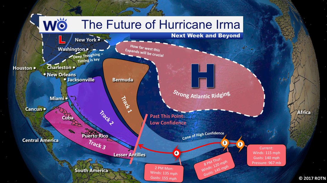
Here's a good graphic I found on twitter via @HenryMargusity
Posted on 9/1/17 at 8:29 am to GEAUXmedic
All I can see is disproportionate dick-n-balls in that strong Atlantic ridging
Posted on 9/1/17 at 8:31 am to JetFuelTyga
Damn it! Now I see it too.
This post was edited on 9/1/17 at 8:31 am
Posted on 9/1/17 at 8:58 am to GEAUXmedic
Looks strangely sexual, like a triple penetration. Weird feelings.
Posted on 9/1/17 at 9:05 am to HubbaBubba
I see Irma getting some dick and balls in her future! Congratulations Irma on the sex
Posted on 9/1/17 at 9:06 am to HubbaBubba
quote:
Looks strangely sexual, like a triple penetration. Weird feelings.
you know Grammy Irma liked it that way back in the day
Posted on 9/1/17 at 9:08 am to rds dc
quote:
Even in the short range, the remnants of Harvey will merge with a trough as it moves NE. The evolution of that process will play a role in the strength and orientation of the high over the top of Irma.
If we're going to rely on Harvey for help, we're fricked.
Posted on 9/1/17 at 9:17 am to slackster
off topic... potential Jose has a 50% chance of development over the next 5 days
ETA: 06z GFS didn't develop Jose at all... 00z Euro had Jose develop but die out in the Atlantic before getting to the islands
ETA: 06z GFS didn't develop Jose at all... 00z Euro had Jose develop but die out in the Atlantic before getting to the islands
This post was edited on 9/1/17 at 9:20 am
Posted on 9/1/17 at 9:44 am to ByteMe
1kt = 1.15 mph.
10kt = 11.5 mph
100kt = 115 mph
10kt = 11.5 mph
100kt = 115 mph

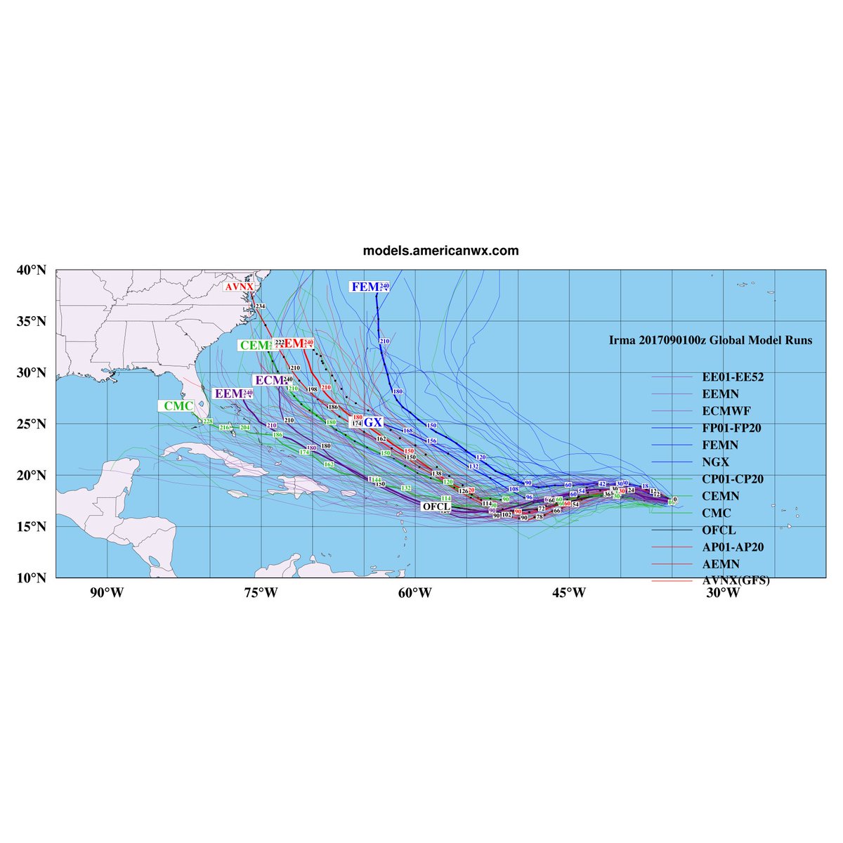
Posted on 9/1/17 at 10:03 am to rds dc

The 0z Euro ensemble split.
Breaking it down:
21 of 51 show a recurve and Irma missing land. That's a damn strong 42%.
15 of 51 show Irma hitting Florida. 29%
9 of 51 show Irma hitting the Carolinas. 18%
4 of 51 show Irma in the GOM. 8%
1 of 51 show Irma hitting the NE. 2%
Posted on 9/1/17 at 10:25 am to HubbaBubba
quote:
triple penetration.
Posted on 9/1/17 at 10:27 am to Duke
Irma needs to make that jog northwest at or before 52W. If it stays on a southwesterly track to 53W before turning north it starts becoming dicey for the east coast. It it goes to 54W, we likely have problems brewing for the GOM and south Florida.
Turn, damn you, Irma! Turn!
Turn, damn you, Irma! Turn!

 Page 22 of 711

Popular
Back to top