- My Forums
- Tiger Rant
- LSU Recruiting
- SEC Rant
- Saints Talk
- Pelicans Talk
- More Sports Board
- Winter Olympics
- Fantasy Sports
- Golf Board
- Soccer Board
- O-T Lounge
- Tech Board
- Home/Garden Board
- Outdoor Board
- Health/Fitness Board
- Movie/TV Board
- Book Board
- Music Board
- Political Talk
- Money Talk
- Fark Board
- Gaming Board
- Travel Board
- Food/Drink Board
- Ticket Exchange
- TD Help Board
Customize My Forums- View All Forums
- Show Left Links
- Topic Sort Options
- Trending Topics
- Recent Topics
- Active Topics
Started By
Message

 2
2

Posted on 2/5/21 at 11:02 am to The Boat
Who here was around for the cold snap in 1989? How did Baton Rouge respond to single digit temperatures?

Posted on 2/5/21 at 11:03 am to trussthetruzz
I blocked that shite from my memory. Mostly because I was four at the time but still, I barely remember it.
Posted on 2/5/21 at 11:04 am to MikeBRLA
quote:
Gas ain’t gonna run the fan though baw.
His 1800 watt generator would
Posted on 2/5/21 at 11:05 am to trussthetruzz
quote:
How did Baton Rouge respond to single digit temperatures?


Posted on 2/5/21 at 11:05 am to The Boat
Ouch......
Posted on 2/5/21 at 11:06 am to dukke v
quote:
dukke v
You really need to give us your prediction here so we know how to prepare.
Posted on 2/5/21 at 11:06 am to TDsngumbo
We need a modified Hurricane bingo card.
Surely someone has already requested.
Surely someone has already requested.
Posted on 2/5/21 at 11:07 am to Jimmy2shoes
quote:
Will this be a nothing burger?
Here is what you should expect

Posted on 2/5/21 at 11:07 am to trussthetruzz
quote:
Who here was around for the cold snap in 1989? How did Baton Rouge respond to single digit temperatures?
Me. It was cold. We survived.
I was in college and was helping a friend run a fireworks stand in Plaqumine. The “new” bridge was closed, due to ice, as were many surface roads. I was able to take the Plaquemine Ferry to get over there - I really needed the money.
Well we barely sold anything over the course of those two weeks due to the cold! Who wants to be outside shooting fireworks when it’s in the teens!
Posted on 2/5/21 at 11:07 am to The Boat
Is that from Terd was on fire watch and blew up Exxon?
Posted on 2/5/21 at 11:10 am to trussthetruzz
quote:I was. It was surreal. The day time highs were in the mid to upper teens and even though we officially only made it down to 8 I’ll never forget the local weather service predicting the low to be between 0 and 5. That would have been amazing. I don’t recall a lot of panic or significant fallout from the extreme cold. I’m sure there were burst pipes around but no ones that I know of.
Who here was around for the cold snap in 1989? How did Baton Rouge respond to single digit temperatures?
Posted on 2/5/21 at 11:12 am to otowntiger
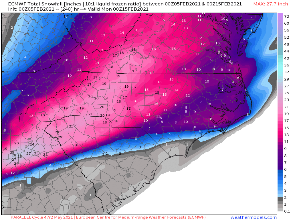
Nearly unanimous GFS ensemble support for SELA winter precip between Thursday to Monday. Thats the best way to look at the realm of possibilities here.
Latest Canadian would absolutely cripple LA and MS.

Latest Canadian would absolutely cripple LA and MS.
This post was edited on 2/5/21 at 11:14 am
Posted on 2/5/21 at 11:14 am to The Boat
quote:
2021??
Maybe the gas line under the gov mansion will explode. One can hope

Posted on 2/5/21 at 11:14 am to trussthetruzz
quote:Neatest snow i have ever seen. No wind, and giant cotton balls falling from the sky.
Who here was around for the cold snap in 1989? How did Baton Rouge respond to single digit temperatures?
The day of the explosion, my roommate and I went to our apartment to see water pouring over all the balconies due to broken pipes. We were on the ground floor and had zero issues. Brightside View. We had been at the mall playing RBI baseball
Posted on 2/5/21 at 11:17 am to AlxTgr
Atlanta would take a month or 2 to open back up
This post was edited on 2/5/21 at 11:19 am
Posted on 2/5/21 at 11:30 am to TDsngumbo

21 degrees at noon on saturday


Posted on 2/5/21 at 11:38 am to trussthetruzz
Unlikely this will happen at this point, but the 12z Canadian is an absolutely crippling ice storm for a lot of us in the southeast. Baton Rouge, to Jackson, to Birmingham, to Chattanooga would be shut down.

For reference, I believe a forecast for just a quarter inch of freezing rain is enough for a Winter Storm Warning to be issued. The idea of getting an inch of freezing rain is just insane.
For reference, I believe a forecast for just a quarter inch of freezing rain is enough for a Winter Storm Warning to be issued. The idea of getting an inch of freezing rain is just insane.
This post was edited on 2/5/21 at 11:40 am
Posted on 2/5/21 at 11:42 am to TDsngumbo
quote:
000
FXUS64 KLIX 051714
AFDLIX
Area Forecast Discussion
National Weather Service New Orleans LA
1114 AM CST Fri Feb 5 2021
.AVIATION...18Z TAF DISCUSSION...MVFR conditions are expected at
most of the terminals this afternoon as an area of light to
moderate rain passes through the region. Visibilities will
generally range from 3 to 5 miles and ceilings will range from
2000 to 4000 feet through 00z. After 00z, conditions should
improve to VFR for a few hours as the rain turns more scattered.
However, stratus build down is expected to occur tonight into
tomorrow morning as the low level cold pool deepens. A return to
MVFR ceilings is expected after 06z with most locations seeing
ceilings between 1000 and 2000 feet. After 12z, further build down
will occur and prevailing IFR and even LIFR ceilings are forecast
for tomorrow morning. PG
&&
.PREV DISCUSSION... /issued 353 AM CST Fri Feb 5 2021/
SYNOPSIS...
Cold front at 3 AM CST was near a Wiggins-Slidell-New Orleans-
Houma line. The front was accompanied by a brief period of heavy
rain, and wind gusts to 30 mph, as well as a 10-15 degree
temperature drop. There is about a 30 mile wide band of rain
behind the leading shower band, but a dry period in between the
two. Temperatures at 3 AM ranged from the upper 40s over
southwest Mississippi to the middle 60s south of Lake
Pontchartrain.
SHORT TERM...
Upper trough/low still spinning over the Great Lakes this
morning, with waves moving through the base of the trough. Local
cold front looks like it`ll get a little further off the coast
today than it appeared yesterday. We`ll see some low level dry air
feeding in behind the front today, but this likely won`t help us
get rid of cloud cover. Once we get past the initial temperature
drop this morning, don`t expect much, if any, temperature
recovery, generally remaining in the lower 50s.
Southern stream shortwaves move through the Gulf Coast States
tonight and again tomorrow night. These will bring opportunities
for more rain late this afternoon and overnight, and again
Saturday afternoon. Heavy rain is not expected. With the dry low
level air, can`t totally rule out a brief period of sleet at the
precipitation onset well to the north of Interstates 10/12 this
afternoon/evening. Threat isn`t high enough to carry in the
forecast though.
If we are going to see any sun this weekend, it`ll be on Sunday,
which by all indications looks dry.
Temperatures...as noted above, don`t anticipate much, if any,
temperature recovery today, trending below the ECMWF solution
closer to the NAM/GFS/NBM solutions today and tonight. Trending a
few degrees below the warmer guidance as well for
Saturday/Saturday night. Some sunshine on Sunday should allow us
to get near 60 degrees. 35
LONG TERM (Monday through Thursday)...
Operational model forecasts continue to be in fairly decent
agreement through the day Monday, but they quickly diverge beyond
that time. And by midweek, forecast confidence really takes a nose
dive given the wide variety of forecast solutions.
Broad longwave troughing will dominate the CONUS through Monday with
generally WSW flow aloft across the local area. Weak shortwave
embedded in the over flow looks to move through the local area
Monday night into Tuesday. Enhanced lift on the front side of the
shortwave should be enough to fire off isolated to scattered
showers. temperatures should remain above normal through the first
half of next week and have maintained high temperatures in the upper
60s to near 70 Monday and in the low to even mid 70s some locations
on Tuesday.
During the latter part of the week, things just get silly. In
general, expect an arctic front to make its way southward but just
how far south it gets and where the core of the air mass moves
remain in question. Locally, the biggest challenge is determining
when a cold front will move through and how strong it will be when
it gets here. I`ll go ahead and mention at this point that by
Thursday morning, there is a 30-35 degree difference in the forecast
minimum temperatures between the high and low members of the ECMWF
ensemble across our forecast area. That kind of spread hardly lends
itself to any confidence in the forecast other than confidence the
deterministic forecast will be wrong. Given that the NBM is fairly
close to the ECMWF ensemble mean, saw no reason to stray much from
it at this time. The resultant blend indicates a frontal passage
some time Wednesday/Wednesday night with a reinforcing blast for the
weekend. Currently the official forecast goes out through Thursday
and am not carrying any freezing temperatures by that time.
Will also go ahead and reinforce some messaging from the previous
forecast package and mention that going beyond the current forecast
period there is some potential that moisture would overlap with
temperatures cold enough to support wintry precip. However, anyone
who tries to convince you that this is a sure thing is lying.
Remember that 30 degree temperature spread on Thursday? It doesn`t
get much better Friday into the weekend. Bottom line - we`re just
going to have to see how things trend over the next few days before
we have any kind of confidence in what might happen.

 Page 15 of 284

Popular
Back to top