- My Forums
- Tiger Rant
- LSU Recruiting
- SEC Rant
- Saints Talk
- Pelicans Talk
- More Sports Board
- Winter Olympics
- Fantasy Sports
- Golf Board
- Soccer Board
- O-T Lounge
- Tech Board
- Home/Garden Board
- Outdoor Board
- Health/Fitness Board
- Movie/TV Board
- Book Board
- Music Board
- Political Talk
- Money Talk
- Fark Board
- Gaming Board
- Travel Board
- Food/Drink Board
- Ticket Exchange
- TD Help Board
Customize My Forums- View All Forums
- Show Left Links
- Topic Sort Options
- Trending Topics
- Recent Topics
- Active Topics
Started By
Message
re: Storm Aftermath - Hurricane Matthew will be Retired
Posted on 10/8/16 at 7:15 am to TypoKnig
Posted on 10/8/16 at 7:15 am to TypoKnig
The problem for Charleston is that the winds are still onshore and the astronomical tide is starting to come back in. The next high tide in a few hours will possibly raise the overall water level about 2 feet higher than the last one because the onshore winds have pushed in enough water to offset the normal low tide.
 1
1


Posted on 10/8/16 at 7:18 am to VaBamaMan
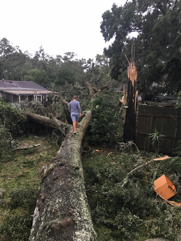
quote:This doesn't do it justice either (canopy extends twice the width of the photo), but it gives a little more perspective on the size of the trunk.
That picture doesn't even do it justice. That tree's size is beyond belief. Fingertip to fingertip, it would probably take close to 6 adults to reach all the way around it. It's truly an incredible tree. Those branches close to the ground are as wide as a twin bed. The big one on the right is almost as wide as a full in spots.

Posted on 10/8/16 at 7:34 am to NC_Tigah
Posted on 10/8/16 at 7:39 am to NorthEndZone
quote:Hopefully the backside will pull some of that water out.
The problem for Charleston is that the winds are still onshore and the astronomical tide is starting to come back in. The next high tide in a few hours will possibly raise the overall water level about 2 feet higher than the last one because the onshore winds
Posted on 10/8/16 at 7:40 am to TypoKnig
Feel really lucky here in downtown Summerville. No real damage and still with power so far. Hope the rest of the lowcountry people on here fair well.

Posted on 10/8/16 at 7:41 am to NC_Tigah
That's a serious tree. Damn.
Posted on 10/8/16 at 8:02 am to dukke v
Just saw a weather channel report from Charleston Harbor. Encouraging actually.
None of the live cams on Sullivan's Island or Isle of Palms seem to be working. Presume they lost power. Sounds like this thing has torn several other barrier islands up.
None of the live cams on Sullivan's Island or Isle of Palms seem to be working. Presume they lost power. Sounds like this thing has torn several other barrier islands up.

Posted on 10/8/16 at 8:04 am to NC_Tigah
I'm 100 miles inland and just lost power
Posted on 10/8/16 at 8:10 am to NC_Tigah
Looking at the weather channel report from Lockwood and it honestly doesn't look worse than last year's flood water-wise. Obviously that's just one small part of the city and doesn't include the islands that took the worst.
I'll reserve overall judgement until after high tide today and seeing my house but tentatively optimistic as of now.
I'll reserve overall judgement until after high tide today and seeing my house but tentatively optimistic as of now.
This post was edited on 10/8/16 at 8:10 am
Posted on 10/8/16 at 8:15 am to metallica81788
quote:That's where our beach place is.
doesn't include the islands that took the worst.
Posted on 10/8/16 at 8:15 am to CarolinaGamecock99
Luckily we still have power here in my part of Dorchester County, the storm hasn't been that bad here.
Posted on 10/8/16 at 8:35 am to Gullah Gullah Island
I've been able to catch some of the twitter videos of downtown. Colonial lake is overflowing with 2 feet everywhere, Calhoun has at least 2 feet, waterfront park has 2 feet. Lots of flooding near Dorchester Rd. Seems like some but minimal flooding in MtP. No word on a lot of the other neighborhoods though.
Posted on 10/8/16 at 8:39 am to metallica81788
Thanks for the update. Think we will wait till tomorrow to come back. Y'all stay dry

Posted on 10/8/16 at 8:50 am to rds dc
The current track looks like Squidward's nose. 


Posted on 10/8/16 at 9:04 am to HubbaBubba
or a massive peen.
Posted on 10/8/16 at 9:22 am to jefffan
quote:Then it should be renamed to Hurricane Foley.
or a massive peen
Posted on 10/8/16 at 9:38 am to NC_Tigah
quote:
Hopefully the backside will pull some of that water out.
The winds have shifted and the water is coming down rapidly. It's all about timing of the surge and the astronomical tide cycle. As bad as the water was in Charleston, it could have been much worse had the timing been different.


This post was edited on 10/8/16 at 9:51 am
Posted on 10/8/16 at 9:48 am to HubbaBubba
Looks like there was significant tree damage in coastal areas overnight. Seeing lots of pics like this one from Savannah.
The main threat today appears to be inland flash flooding across NC with many areas forecast to see 8"+ with some areas approaching 15"+

Then beyond that, most guidance agrees in the loop. The Euro EPS keeps trending farther into the Gulf but only a small portion of members show any strengthening over the Gulf. The 00z Euro has sheared TS into Louisiana near the end of the run.

The main threat today appears to be inland flash flooding across NC with many areas forecast to see 8"+ with some areas approaching 15"+
Then beyond that, most guidance agrees in the loop. The Euro EPS keeps trending farther into the Gulf but only a small portion of members show any strengthening over the Gulf. The 00z Euro has sheared TS into Louisiana near the end of the run.
Posted on 10/8/16 at 9:49 am to NorthEndZone
The river crest has been revised upward to greater than the flood of a year ago in Conway, SC.
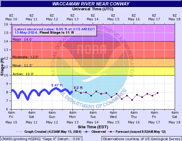
Historic Crests
(1) 17.80 ft on 09/30/1928
(2) 17.60 ft on 09/27/1999
(3) 16.20 ft on 10/10/2015
(4) 16.07 ft on 10/08/2015
I'm not familiar with the area but these descriptions sound like bad flooding.
15 Residential flooding will continue to worsen. The Conway Marina will be flooded. Railroad trestles in downtown Conway will flood at 15.9 feet.
14 Flood waters will worsen and affect several residential properties and roads at Riverfront South, Lees Landing, Savannah Bluff, Pitch Landing, Jackson Bluff and Bucksville.
13 Flooding will occur in residential areas off Business 501, Highway 905 and Highway 90. Water levels one foot deep will surround approximately 20 homes in the Savannah Bluff area. Flood waters will also surround homes in the Lees Landing, Pitch Landing and Riverfront South communities. Flooding will occur near a few homes on Oak Street as well as at Punch Bowl and Pitch Landing.
12 Flooding will worsen in the Lees Landing, Riverfront South, Pitch Landing and Savannah Bluff communities. Flood waters will begin to affect homes north of Conway on Riverside Drive. Swamps will be heavily flooded.

Posted on 10/8/16 at 9:50 am to bayouboy33
quote:
updates from Charleston Metallica or gasman? Wondering if I will have a house to come home to
hoping the same. While I'm in N Charleston, I'm close to the Ashley River.

 Page 177 of 181

Popular
Back to top