- My Forums
- Tiger Rant
- LSU Recruiting
- SEC Rant
- Saints Talk
- Pelicans Talk
- More Sports Board
- Winter Olympics
- Fantasy Sports
- Golf Board
- Soccer Board
- O-T Lounge
- Tech Board
- Home/Garden Board
- Outdoor Board
- Health/Fitness Board
- Movie/TV Board
- Book Board
- Music Board
- Political Talk
- Money Talk
- Fark Board
- Gaming Board
- Travel Board
- Food/Drink Board
- Ticket Exchange
- TD Help Board
Customize My Forums- View All Forums
- Show Left Links
- Topic Sort Options
- Trending Topics
- Recent Topics
- Active Topics
Started By
Message

 1
1


Posted on 3/19/18 at 6:36 pm to slackster
Yeah, about the time I posted that one of the radars gave me a good velocity look.
I’m sure the stuff we were looking at earlier was solid but this border warning looks like the big boy today.
I’m sure the stuff we were looking at earlier was solid but this border warning looks like the big boy today.
Posted on 3/19/18 at 6:38 pm to Scoop
Posted on 3/19/18 at 6:40 pm to NorthEndZone
Classic looking super cell and yes, looks the part on velocity too. Looks like long runner number two unfortunately
Posted on 3/19/18 at 6:42 pm to Duke
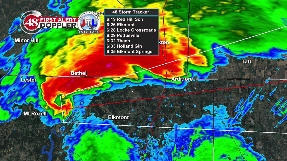
Combined population of Ardmore, AL and TN is about 3,000. I hope they are all taking cover!
Posted on 3/19/18 at 6:42 pm to Duke
Looks like another one popping up heading towards Guntersville

Posted on 3/19/18 at 6:44 pm to greenwave
Hopefully Mildred's in Ardmore makes it through... It's decent cheap food

Posted on 3/19/18 at 6:45 pm to greenwave
It looks like the system is moving ever so slightly north as it moves east. Rather than to the SW towards ATL, Is that an accurate read based on my wholly amateur eye?

Posted on 3/19/18 at 6:48 pm to MrLarson
Was that Scott Tire and Equip?
Posted on 3/19/18 at 6:48 pm to NorthEndZone
Not liking the look of storms heading to Cullman, last frame on radar had a possible tornado pop out. Can't confirm anything off that but don't like it.
Posted on 3/19/18 at 6:49 pm to razorbackfan4life
quote:
He's on the southern tornado south of Decatur. Haven't seen a touchdown yet, but he's on it.
That tornado is scared to touch down after seeing the giant set of balls Jeff has
Posted on 3/19/18 at 6:49 pm to Duke
642 PM CDT MON MAR 19 2018
...A TORNADO WARNING REMAINS IN EFFECT UNTIL 700 PM CDT FOR
NORTHWESTERN MADISON...NORTHEASTERN LIMESTONE AND SOUTHWESTERN
LINCOLN COUNTIES...
At 641 PM CDT, a confirmed tornado was located over Ardmore, or 14
miles northeast of Athens, moving east at 45 mph.
HAZARD...Damaging tornado and quarter size hail.
SOURCE...Weather spotters confirmed tornado south of Ardmore.
IMPACT...Flying debris will be dangerous to those caught without
shelter. Mobile homes will be damaged or destroyed. Damage
to roofs, windows, and vehicles will occur. Tree damage is
likely.
This tornado will be near...
Hazel Green around 700 PM CDT.
Other locations impacted by this tornadic thunderstorm include
Blanche, Fisk, Taft, Elkwood and Holland Gin.
Posted on 3/19/18 at 6:51 pm to Duke
quote:
Not liking the look of storms heading to Cullman, last frame on radar had a possible tornado pop out. Can't confirm anything off that but don't like it.
I've got family in Cullman. My grandmother lives in a trailer but she was aware of things possibly getting rough so I think she's gone to my aunts who has a storm shelter. Im Keeping an eye on this.

Posted on 3/19/18 at 6:51 pm to NorthEndZone
New tornado warning includes the city of Cullman.
Posted on 3/19/18 at 6:52 pm to SM6
We can officially call the Belmont to Decatur warning a long track. It’s been active for 2 1/2 hours.
This post was edited on 3/19/18 at 6:54 pm
Posted on 3/19/18 at 6:55 pm to Lsuhoohoo
Tracking down Pulaski Pike across Hwy 53 in Northern Madison Co.

Posted on 3/19/18 at 6:55 pm to Scoop
Two strong rotations forming just west and south of Eva, AL.
Posted on 3/19/18 at 6:55 pm to Scoop
The border tornado east of Ardmore is looking as tight as his has all evening.
Posted on 3/19/18 at 6:55 pm to Lsuhoohoo
quote:
I've got family in Cullman. My grandmother lives in a trailer but she was aware of things possibly getting rough so I think she's gone to my aunts who has a storm shelter. Im Keeping an eye on this.
They should be in the shelter, I'm seeing a possible tornado on radar to their west moving at Cullman. It's not strong yet (and not warned, so hopefully amount to nil) but better safe than sorry as fast as they're blowing up.
Posted on 3/19/18 at 7:01 pm to Duke
quote:
It's not strong yet (and not warned, so hopefully amount to nil) but better safe than sorry as fast as they're blowing up.
It's warned now. Cullman under the gun.

 Page 9 of 21

Popular
Back to top