- My Forums
- Tiger Rant
- LSU Recruiting
- SEC Rant
- Saints Talk
- Pelicans Talk
- More Sports Board
- Winter Olympics
- Fantasy Sports
- Golf Board
- Soccer Board
- O-T Lounge
- Tech Board
- Home/Garden Board
- Outdoor Board
- Health/Fitness Board
- Movie/TV Board
- Book Board
- Music Board
- Political Talk
- Money Talk
- Fark Board
- Gaming Board
- Travel Board
- Food/Drink Board
- Ticket Exchange
- TD Help Board
Customize My Forums- View All Forums
- Show Left Links
- Topic Sort Options
- Trending Topics
- Recent Topics
- Active Topics
Started By
Message
re: Tropical Storm Isaias - O Canada!
Posted on 8/1/20 at 7:16 pm to Hangit
Posted on 8/1/20 at 7:16 pm to Hangit
Thanks. This one is no where near as stressful as irma and matthew but looks like its riding the same pattern. Weird the last 3 storms have taken very similar paths. Not exact paths but started at the bottom fl. all the way up the state.
This post was edited on 8/1/20 at 7:19 pm
 1
1


Posted on 8/1/20 at 8:16 pm to FLObserver

Posted on 8/1/20 at 8:23 pm to Bobby OG Johnson
That outflow fanning out to the north is quite healthy. Still squeezed to the west and convection remains downshear for the most part.
But much much better looking than this afternoon.
But much much better looking than this afternoon.
Posted on 8/1/20 at 8:52 pm to Duke
quote:
But much much better looking than this afternoon.
Agreed

Posted on 8/1/20 at 10:07 pm to Bobby OG Johnson
NHC running late on the 10pm CDT advisory.
Posted on 8/1/20 at 10:08 pm to Roll Tide Ravens
Probably asleep 
Posted on 8/1/20 at 10:10 pm to Bobby OG Johnson
quote:
BULLETIN
Tropical Storm Isaias Advisory Number 20
NWS National Hurricane Center Miami FL AL092020
1100 PM EDT Sat Aug 01 2020
...ISAIAS CONTINUES TO SLOWLY APPROACH THE SOUTHEAST FLORIDA
COAST...
SUMMARY OF 1100 PM EDT...0300 UTC...INFORMATION
-----------------------------------------------
LOCATION...25.5N 79.1W
ABOUT 80 MI...130 KM ESE OF FORT LAUDERDALE FLORIDA
ABOUT 105 MI...165 KM SE OF WEST PALM BEACH FLORIDA
MAXIMUM SUSTAINED WINDS...70 MPH...110 KM/H
PRESENT MOVEMENT...NW OR 310 DEGREES AT 9 MPH...15 KM/H
MINIMUM CENTRAL PRESSURE...995 MB...29.39 INCHES
Posted on 8/1/20 at 10:11 pm to Bobby OG Johnson
10pm CDT; 11pm EDT advisory
Tropical Storm Isaias Advisory Number 20
NWS National Hurricane Center Miami FL AL092020
1100 PM EDT Sat Aug 01 2020
...ISAIAS CONTINUES TO SLOWLY APPROACH THE SOUTHEAST FLORIDA
COAST...
SUMMARY OF 1100 PM EDT...0300 UTC...INFORMATION
-----------------------------------------------
LOCATION...25.5N 79.1W
ABOUT 80 MI...130 KM ESE OF FORT LAUDERDALE FLORIDA
ABOUT 105 MI...165 KM SE OF WEST PALM BEACH FLORIDA
MAXIMUM SUSTAINED WINDS...70 MPH...110 KM/H
PRESENT MOVEMENT...NW OR 310 DEGREES AT 9 MPH...15 KM/H
MINIMUM CENTRAL PRESSURE...995 MB...29.39 INCHES

Posted on 8/1/20 at 10:24 pm to Roll Tide Ravens
It's always sad watching the weather channel trying to keep people interested in a weak system.
Posted on 8/1/20 at 10:54 pm to The Boat
quote:
It's always sad watching the weather channel trying to keep people interested in a weak system.
Their website had a red warning header that was labeled Hurricane Dorian earlier today.
Posted on 8/2/20 at 12:37 am to Bobby OG Johnson

Don’t stamp the “nothing burger” on it yet.
Posted on 8/2/20 at 12:57 am to Dlab2013
Live update from west palm. We have sustained winds of 6 if not 7 mph. Felt a few sprinkles as well. My kids swing seems to be perhaps moving a bit.
Hope we make it.
Hope we make it.
This post was edited on 8/2/20 at 12:59 am
Posted on 8/2/20 at 6:00 am to Bobby OG Johnson
Not unlike the hyperactive kids on TDS.
Posted on 8/2/20 at 6:59 am to Dlab2013
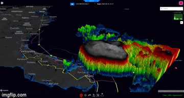
Good blowup of convection this morning

Posted on 8/2/20 at 8:38 am to Roll Tide Ravens
He's just being a bitch.
Pretty cool graphic this morning retweeted by Spann.
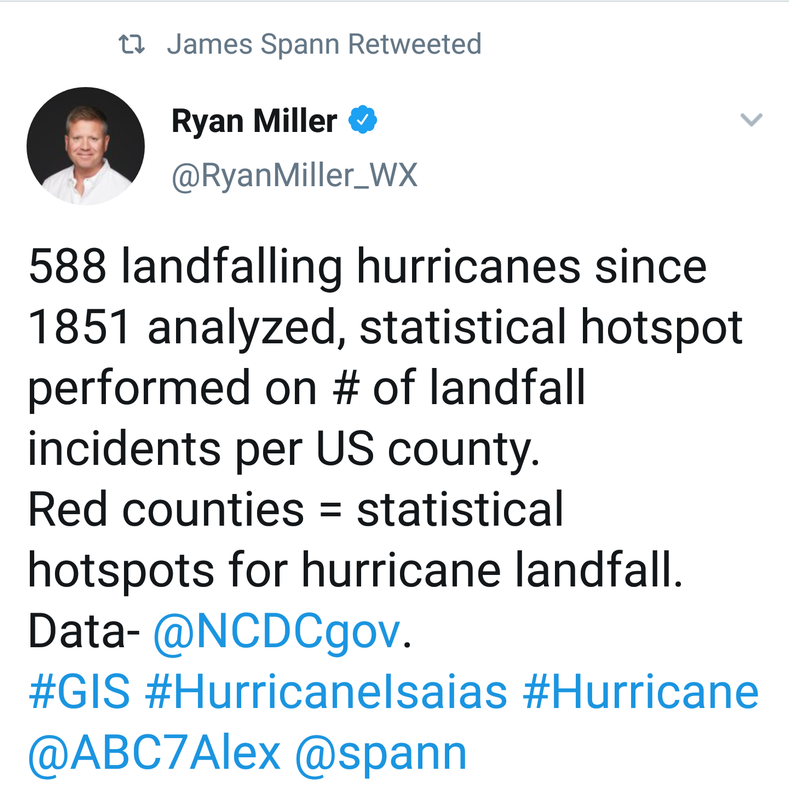
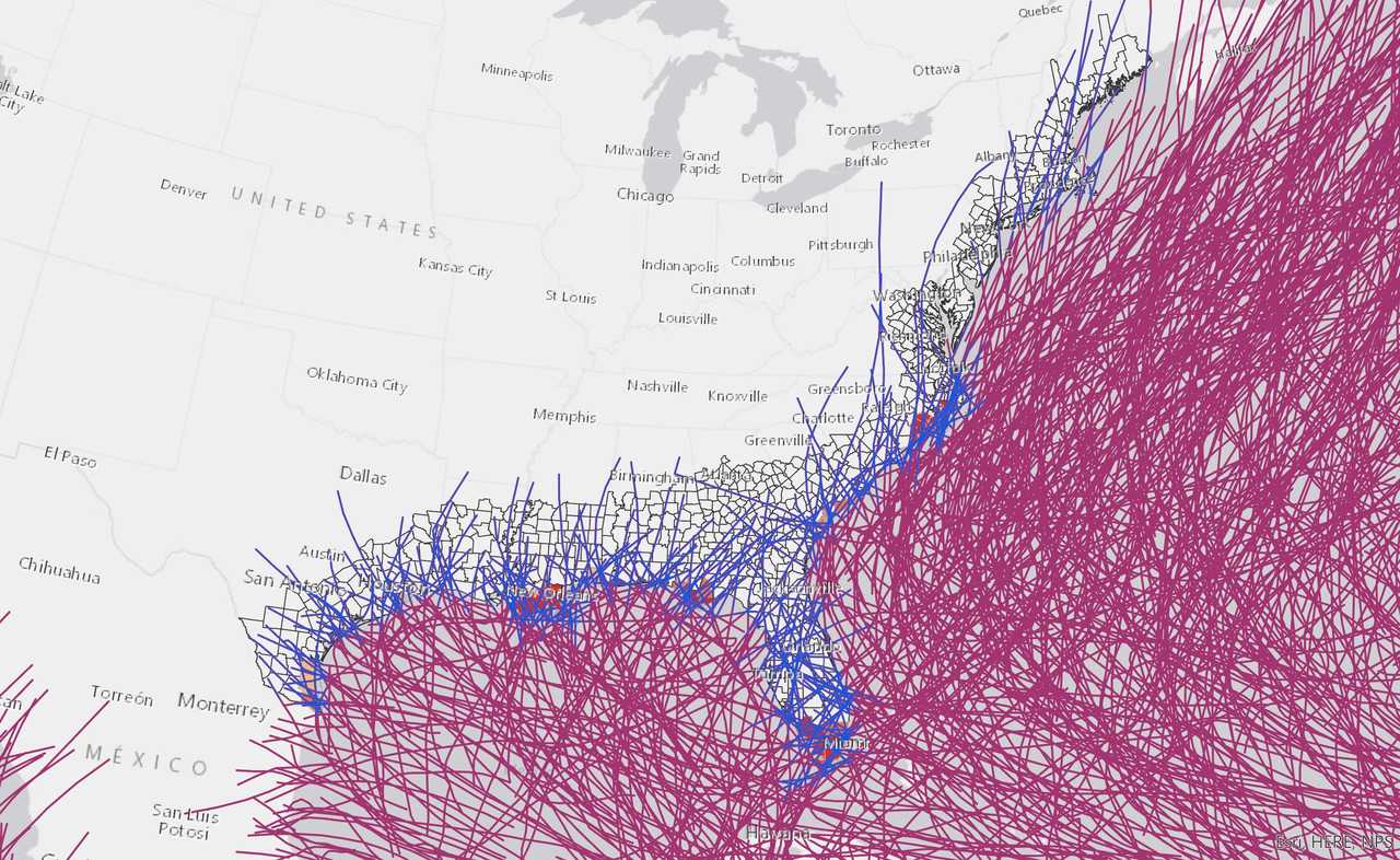
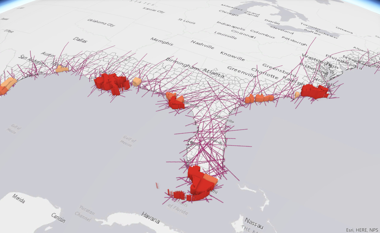
Pretty cool graphic this morning retweeted by Spann.
Posted on 8/2/20 at 10:16 am to Domeskeller

Posted on 8/2/20 at 10:51 am to Domeskeller
quote:
Why are you such a shithead?
He’s just retarded, don’t be an ableist.
Posted on 8/2/20 at 10:54 am to FutureMikeVIII


Possibility it restrengthens and hits SC around Willmington as a Cat 1.
Posted on 8/2/20 at 12:25 pm to Dlab2013
He is back to hurricane force winds at flight level and about 63 knots surface estimated SFMR. The NHC may go back up to 70 mph at 1 PM CDT.
This is a miss for Florida but will probably be a headache for SC / NC /VA

This is a miss for Florida but will probably be a headache for SC / NC /VA
This post was edited on 8/2/20 at 12:27 pm
Posted on 8/2/20 at 12:42 pm to NorthEndZone
quote:
This is a miss for Florida but will probably be a headache for SC / NC /VA
not good for those states... the storm has more time over the warmer waters of the gulfstream and will soon get more in line with the winds that are currently shearing it... which would allow it to strengthen a bit

 Page 42 of 50

Popular
Back to top