- My Forums
- Tiger Rant
- LSU Recruiting
- SEC Rant
- Saints Talk
- Pelicans Talk
- More Sports Board
- Coaching Changes
- Fantasy Sports
- Golf Board
- Soccer Board
- O-T Lounge
- Tech Board
- Home/Garden Board
- Outdoor Board
- Health/Fitness Board
- Movie/TV Board
- Book Board
- Music Board
- Political Talk
- Money Talk
- Fark Board
- Gaming Board
- Travel Board
- Food/Drink Board
- Ticket Exchange
- TD Help Board
Customize My Forums- View All Forums
- Show Left Links
- Topic Sort Options
- Trending Topics
- Recent Topics
- Active Topics
Started By
Message
Best GPS software for SE La. Coast
Posted on 2/22/16 at 11:41 am
Posted on 2/22/16 at 11:41 am
I'm in the market for a new GPS and was trying to figure out what would be the best software for the SE La. Coast. Which brand is the most current and most detailed as well as easy-to-use? Also opinion on Garmin vs. Lowrance units.
 7
7


Posted on 2/22/16 at 12:24 pm to Johnny Reb 14
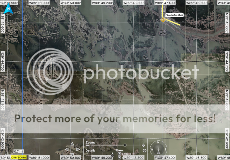
for what i use mine for, gamin birds eye with garmin base camp works good for me. Its the only one i've ever used outside of regular map packs with a boat gps, so I'm probably not the best person to ask. I have a garmin oregon 650 and i don't have a boat GPS. I just use the handheld. It looks a whole lot like google earth but a lot of the bays and rivers aren't labeled like google earth is. I know theres a way to get google earth screenshots on your gps in the right locations and what not but it seemed like too much of an endeavor for me. you can also bring waypoints and tracks to and from google earth. heres a screenshot from around delacroix to see what it looks like, it looks exactly the same on the gps screen to me.
Posted on 2/22/16 at 12:25 pm to bigbuckdj
I have read good reviews on the standard mapping e card as well.
Posted on 2/22/16 at 12:44 pm to Johnny Reb 14
I would lean towards a Lowrance Unit. I had an HDS in my old boat and loved it, new to me boat came with a Garmin 740S, not a fan at all. This Garmin does not currently support any of the satellite map cards.
The Standard Mapping cards are nice and work on the Lowrance units.
The Standard Mapping cards are nice and work on the Lowrance units.
Posted on 2/22/16 at 12:47 pm to Ranger198
My boat has an old Lowrance LCX-37c circa 2007 i can't wait to upgrade to newer tech.
Posted on 2/22/16 at 12:54 pm to Johnny Reb 14
I have a Legend Cartography Geaux Card that I use in the Lowrance Elite 7 in my boat. Lowrance has the most compatible map cards to chose from. The Geaux Card is awesome. It has navigation markers on it as well which is nice when you are running some of the bigger waterways down south.

Posted on 2/22/16 at 1:02 pm to Johnny Reb 14
Lowrance, Standard Mapping LA1 Card, Navionics Platinum is what I use.
Standard Mapping for the maps and I like Navionics for the contour lines which is not shown on most other mapping cards.
Standard Mapping for the maps and I like Navionics for the contour lines which is not shown on most other mapping cards.
Posted on 2/22/16 at 1:13 pm to Johnny Reb 14
Lowrance HDS and any of satellite mapping cards are the way to go.
Posted on 2/22/16 at 1:23 pm to Ranger198
quote:
I would lean towards a Lowrance Unit. I had an HDS in my old boat and loved it, new to me boat came with a Garmin 740S, not a fan at all. This Garmin does not currently support any of the satellite map cards. The Standard Mapping cards are nice and work on the Lowrance units.
Not true. You could upgrade to a newer GPSMAP, echoMAP, or XSV model and take advantage of their LA Bayou Satellite Imagery BlueChart G2 card. It is a nice addition to those units for our area. LINK
There are some screenshots, from a customer's boat, that I added to this thread on thehulltruth.com. LINK
Posted on 2/22/16 at 1:30 pm to Johnny Reb 14
Multiple threads on this already but myself and a few other posters here make our own satellite image maps for Lowrance units HDI and above. Its pretty simple and free. If you feel like putting in the time and end up with a lowrance you can make your own maps
Posted on 2/22/16 at 1:38 pm to davidwademarine
That is correct, I should have said it does not work with my current unit the Garmin 740S.
Those screenshots do look good.
Those screenshots do look good.

Posted on 2/22/16 at 2:48 pm to Johnny Reb 14
Standard is the best. Get the Lowrance for that reason alone.
Posted on 2/22/16 at 2:57 pm to SeaPickle
quote:
Multiple threads on this already but myself and a few other posters here make our own satellite image maps for Lowrance units HDI and above. Its pretty simple and free. If you feel like putting in the time and end up with a lowrance you can make your own maps
I am one of those who makes maps for the lowrance units as well. I have all of sela made and its made navigating much easier.
as for the garmin gps, that is an awesome chart for the price and seems to be very detailed.
Posted on 2/22/16 at 4:26 pm to WHODAT514
I have the Garmin echoMap (brand new) and haven't ran boat with it yet, I do wish they had "colored" the water more like the Standard Maps. TBH the contrast difference from water to land isn't that significant. But I got 7inch GPS and maps for entire coastal area for $700 vs $1200 for lowrance, plus I've only owned Garmin units.
Posted on 2/22/16 at 5:45 pm to Redlos
quote:
$1200 for lowrance
A lowrance HDS 7 is much less than $1200
Posted on 2/22/16 at 6:19 pm to civiltiger07
I paid 750$ for a hds7 gen 2 touch...the 9 can be found for about 900 now if they have any gen2 units left
Posted on 2/22/16 at 7:07 pm to WHODAT514
If anyone wants to send me their map of SELA that is compatible with a Lowrance Elite-5 Chirp I'll gladly write a review on it. My email is mrcreed2610@gmail.com.
Posted on 2/22/16 at 8:22 pm to mrcreed
I've had a few different Garmin units but currently running the Lowrance hds 7 in bay boat just for the standard map e-card for Biloxi marsh area. It's definitely less user friendly, I find, than my garmin units were but the e-card is a gamechanger. Hope something comes out for garmin units soon if not already
Posted on 2/22/16 at 9:08 pm to mrcreed
Map files will be too large to email if it covers an area the size of entire SELA.
Elite-5 HDI or DSI? Homemade maps will work with HDI or above models. DSI is just down scan imaging.
Elite-5 HDI or DSI? Homemade maps will work with HDI or above models. DSI is just down scan imaging.
This post was edited on 2/23/16 at 7:34 am
Posted on 2/22/16 at 9:37 pm to SeaPickle
HDI. Nvm, preciate the looking out SeaPickle.

 Page 1 of 3

Popular
Back to top