- My Forums
- Tiger Rant
- LSU Recruiting
- SEC Rant
- Saints Talk
- Pelicans Talk
- More Sports Board
- Winter Olympics
- Fantasy Sports
- Golf Board
- Soccer Board
- O-T Lounge
- Tech Board
- Home/Garden Board
- Outdoor Board
- Health/Fitness Board
- Movie/TV Board
- Book Board
- Music Board
- Political Talk
- Money Talk
- Fark Board
- Gaming Board
- Travel Board
- Food/Drink Board
- Ticket Exchange
- TD Help Board
Customize My Forums- View All Forums
- Show Left Links
- Topic Sort Options
- Trending Topics
- Recent Topics
- Active Topics
Started By
Message
 2
2

Posted on 12/22/22 at 11:53 am to LootieandtheBlowfish
Getting snow flurries in mckinney tx
Posted on 12/22/22 at 12:25 pm to FortyCreek
The front is now almost to Longview, TX. Shreveport, get your shite together.
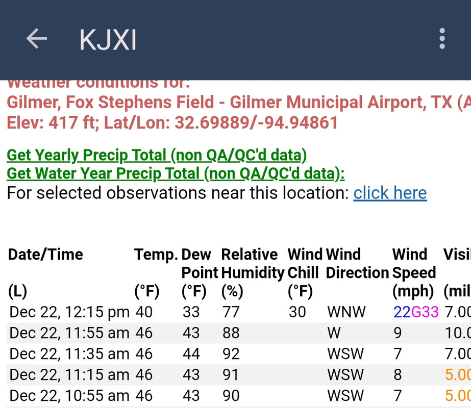
Gilmer Municipal Airport:
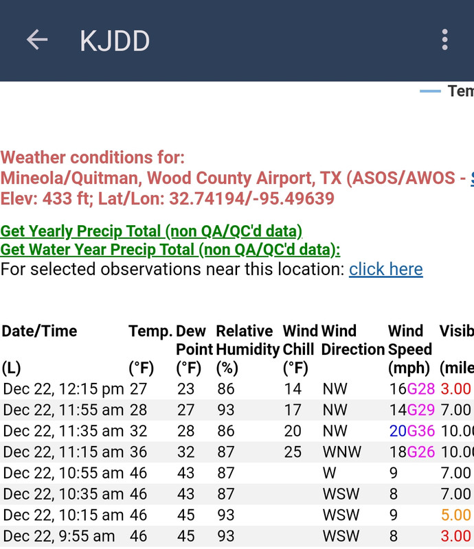
Wood County Airport (Mineola/Quitman):
Gilmer Municipal Airport:
Wood County Airport (Mineola/Quitman):
This post was edited on 12/22/22 at 12:34 pm

Posted on 12/22/22 at 12:32 pm to LootieandtheBlowfish
The front is quickly approaching Shreveport and visible on reflectivity

Posted on 12/22/22 at 12:33 pm to The Boat
quote:
The front is quickly approaching Shreveport and visible on reflectivity
It has been interesting to watch it on radar.
Posted on 12/22/22 at 12:39 pm to The Boat
Now down to 32° with a 22mph wind and a gust to 33mph at the Gilmer airport.
Posted on 12/22/22 at 12:40 pm to LegendInMyMind
It's howling. At this rate I won't have to rake leaves.

Posted on 12/22/22 at 12:40 pm to LegendInMyMind
Running some quick errands before ours sets in around 5-6 pm. Then hunkering down.
Posted on 12/22/22 at 1:18 pm to bayoubengals88
136 degree temperature range from MT to FL...
quote:
National High and Low Temperature (for the contiguous United States)
NWS Weather Prediction Center, College Park, MD
Issued 1 pm EST Thursday, December 22, 2022
High Temperature for Wednesday, December 21, 2022
(as received by 1 pm EST December 22)
86 at Bahia Honda Key, FL
86 at 17 miles east-southeast of Ochopee, FL
Low Temperature for Thursday, December 22, 2022
(as received by 1 pm EST December 22)
-50 at 13 miles north of White Sulphur Springs, MT
-50 at Elk Park, MT
Posted on 12/22/22 at 1:31 pm to Havoc
I know it's nothing compared to what the "main event" will be but this wind is already a bit chilly in Tennsippibama

Posted on 12/22/22 at 2:08 pm to bayoubengals88
It's an impressive front to look at on the maps.


Posted on 12/22/22 at 2:09 pm to LegendInMyMind
The wind is driving me insane. It needs to move out quickly.

Posted on 12/22/22 at 2:12 pm to Roll Tide Ravens
That’s a very powerful picture.
Posted on 12/22/22 at 2:12 pm to cgrand
quote:
Ice can’t get any colder than 32 out in your yard
No bro
Posted on 12/22/22 at 2:13 pm to bayoubengals88
It's a cold world...
Posted on 12/22/22 at 2:18 pm to TexasTiger33
Front just made it to Shreveport with a heck of a wind gust
Posted on 12/22/22 at 2:20 pm to TexasTiger33
Usually it’s nice to be outside when the front rolls through, feels so good. Maybe not this time though. I still want to see for myself.
Posted on 12/22/22 at 2:21 pm to SelaTiger
I’m becoming irrationally angry at the wind.

Posted on 12/22/22 at 2:22 pm to LSUGrrrl
Around the Baton Rouge area preparations should be rushed to completion. A chance of snow tonight.


This post was edited on 12/22/22 at 2:25 pm

Posted on 12/22/22 at 2:30 pm to bayoubengals88
URGENT - WINTER WEATHER MESSAGE
National Weather Service Paducah KY
1019 AM CST Thu Dec 22 2022
ILZ087-090-091-094-INZ081-082-085>088-KYZ001>022-230030-
/O.UPG.KPAH.WW.Y.0012.221222T2000Z-221223T0600Z/
/O.NEW.KPAH.WS.W.0004.221222T2000Z-221223T0600Z/
/O.CON.KPAH.WC.W.0001.221223T0000Z-221223T1800Z/
Gallatin-Pope-Hardin-Massac-Gibson-Pike-Posey-Vanderburgh-Warrick-
Spencer-Fulton-Hickman-Carlisle-Ballard-McCracken-Graves-
Livingston-Marshall-Calloway-Crittenden-Lyon-Trigg-Caldwell-
Union KY-Webster-Hopkins-Christian-Henderson-Daviess-McLean-
Muhlenberg-Todd-
Including the cities of Shawneetown, Golconda, Elizabethtown,
Metropolis, Fort Branch, Petersburg, Poseyville, Evansville,
Boonville, Rockport, Hickman, Clinton, Bardwell, Wickliffe,
Paducah, Mayfield, Smithland, Benton, Murray, Marion, Eddyville,
Cadiz, Princeton, Morganfield, Dixon, Madisonville, Hopkinsville,
Henderson, Owensboro, Calhoun, Greenville, and Elkton
1019 AM CST Thu Dec 22 2022 /1119 AM EST Thu Dec 22 2022/
...WINTER STORM WARNING IN EFFECT FROM 2 PM THIS AFTERNOON TO
MIDNIGHT CST TONIGHT...
...WIND CHILL WARNING REMAINS IN EFFECT FROM 6 PM THIS EVENING TO
NOON CST FRIDAY...
* WHAT...For the Winter Storm Warning, heavy snow expected.
Total snow accumulations of 2 to 4 inches. Winds gusting as
high as 40 mph. For the Wind Chill Warning, dangerously cold
wind chills expected. Wind chills as low as 30 below zero.
* WHERE...Portions of southern Illinois, southwest Indiana and
western Kentucky.
* WHEN...For the Winter Storm Warning, from 2 PM this afternoon
to midnight CST tonight. For the Wind Chill Warning, from 6 PM
this evening to noon CST Friday.
* IMPACTS...Plan on slippery road conditions. Patchy blowing
snow could significantly reduce visibility. The hazardous
conditions could impact the morning or evening commute. The
cold wind chills could cause frostbite on exposed skin in as
little as 30 minutes.
* ADDITIONAL DETAILS...Isolated higher amounts of snow cannot be
ruled out if heavier snow bands develop.
PRECAUTIONARY/PREPAREDNESS ACTIONS...
If you must travel, keep an extra flashlight, food, and water in
your vehicle in case of an emergency.
Avoid outside activities if possible. When outside, make sure you
wear appropriate clothing, a hat, and gloves.

 Page 39 of 62

Popular
Back to top