- My Forums
- Tiger Rant
- LSU Recruiting
- SEC Rant
- Saints Talk
- Pelicans Talk
- More Sports Board
- Winter Olympics
- Fantasy Sports
- Golf Board
- Soccer Board
- O-T Lounge
- Tech Board
- Home/Garden Board
- Outdoor Board
- Health/Fitness Board
- Movie/TV Board
- Book Board
- Music Board
- Political Talk
- Money Talk
- Fark Board
- Gaming Board
- Travel Board
- Food/Drink Board
- Ticket Exchange
- TD Help Board
Customize My Forums- View All Forums
- Show Left Links
- Topic Sort Options
- Trending Topics
- Recent Topics
- Active Topics
Started By
Message
 3
3


Posted on 9/7/23 at 9:56 pm to Roll Tide Ravens
Also from the NHC discussion:
quote:
Additional strengthening appears likely, as Lee remains in a low-shear environment and over very warm waters near 30 degrees Celsius, and there are no signs of an imminent eyewall replacement. In fact, based on guidance from UW-CIMSS, the probability of a secondary eyewall formation during the next 24 hours is well below climatology. There is some chance that moderate deep-layer southwesterly shear could develop over the hurricane, but this could be offset by strong upper-level divergence and thus have little to no impact. To account for the recent rate of intensification, the NHC intensity forecast is slightly above the IVCN and HCCA consensus aids and shows a peak intensity of 155 kt in 12 hours. Amazingly, the 1800 UTC HAFS-A and -B runs show a peak intensity between 170-180 kt, but that's getting into rarefied air. The NHC forecast will be adjusted accordingly if those solutions begin looking like a more distinct possibility. Only very gradual weakening is shown after 12-24 hours, and it is likely that Lee's intensity will fluctuate for much of the forecast period. Lee is forecast to remain a dangerous category 4 or 5 hurricane for the next 5 days.
Posted on 9/7/23 at 9:56 pm to Roll Tide Ravens
180 is about as aggressive as ive seen the NHC go. For good reason. Hot water. Amazing outflow. No shear.
Thermodynamics says, we gonna get a beast.
Thermodynamics says, we gonna get a beast.
Posted on 9/7/23 at 9:57 pm to NorthEndZone
wonder if it can beat out patricia (215,872)
This post was edited on 9/7/23 at 10:02 pm
Posted on 9/7/23 at 10:02 pm to trussthetruzz
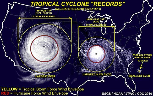
World record was Patricia in winds (215 mph)
Atlantic record was Allen in winds (190 mph)
World record was Tip in pressure (870 mb)
Atlantic record was Wilma in pressure (882 mb)
Atlantic record was Allen in winds (190 mph)
World record was Tip in pressure (870 mb)
Atlantic record was Wilma in pressure (882 mb)
Posted on 9/7/23 at 10:05 pm to LSUneaux
quote:
After passing Guam, Tip rapidly intensified and reached peak sustained winds of 305 km/h (190 mph)[nb 1] and a worldwide record-low sea-level pressure of 870 hPa (25.69 inHg) on October 12. At its peak intensity, Tip was the largest tropical cyclone on record, with a wind diameter of 2,220 km (1,380 mi).

Posted on 9/7/23 at 10:08 pm to NorthEndZone
quote:
180 mph - that's some WESTPAC wind speed there.
Agreed. This is some west Pac shite we’re getting into. Glad this beast is staying out of the GOM. The insurance industry would just collapse outright. But hey if it’s staying out to sea, go ahead and break every record.
Posted on 9/7/23 at 10:09 pm to LSUneaux
What makes Westpac storms so much stronger? The length of runway the Pacific gives them?

Posted on 9/7/23 at 10:09 pm to LSUneaux
I needed that size conceptualized for me, and god damn…
Posted on 9/7/23 at 10:11 pm to Joshjrn
I thought Katrina covered the whole Gulf at one point...

Posted on 9/7/23 at 10:12 pm to LSUneaux
870???? That’s sounds impossible.
Posted on 9/7/23 at 10:13 pm to PassingThrough
quote:
I thought Katrina covered the whole Gulf at one point...
She was big, but not quite that big.

Posted on 9/7/23 at 10:14 pm to Roll Tide Ravens
Still a powerful bitch in that pic…
Posted on 9/7/23 at 10:15 pm to PassingThrough
quote:
What makes Westpac storms so much stronger? The length of runway the Pacific gives them?
Warm water year round, lower shear
They really do have a 12 month season
Posted on 9/7/23 at 10:15 pm to NorthEndZone
Ship tracking site should be interesting to follow in the next few days. Currently shows alot of vessels in the vicinity of the path including a few yachts.
Vessel tracker
If you activate the site's wind feature, you should have no trouble finding Lee.
Vessel tracker
If you activate the site's wind feature, you should have no trouble finding Lee.
Posted on 9/7/23 at 10:16 pm to Roll Tide Ravens
I’ll never forget waking up to that satellite image thinking ‘oh my god. Checkmate’
Posted on 9/7/23 at 10:19 pm to PassingThrough
Gilbert
Posted on 9/7/23 at 10:21 pm to dukke v
I think they actually flew a plane into Tip.
Tip is also pretty much on the mountaintop of tropical cyclones in the modern era.
Tip is also pretty much on the mountaintop of tropical cyclones in the modern era.
Posted on 9/7/23 at 10:21 pm to I 10 one lane merge
quote:
I’ll never forget waking up to that satellite image thinking ‘oh my god. Checkmate’
It’s the scariest looking eye structure I’ve ever seen. It still makes me uncomfortable looking at it.

 Page 11 of 18

Popular
Back to top