- My Forums
- Tiger Rant
- LSU Recruiting
- SEC Rant
- Saints Talk
- Pelicans Talk
- More Sports Board
- Winter Olympics
- Fantasy Sports
- Golf Board
- Soccer Board
- O-T Lounge
- Tech Board
- Home/Garden Board
- Outdoor Board
- Health/Fitness Board
- Movie/TV Board
- Book Board
- Music Board
- Political Talk
- Money Talk
- Fark Board
- Gaming Board
- Travel Board
- Food/Drink Board
- Ticket Exchange
- TD Help Board
Customize My Forums- View All Forums
- Show Left Links
- Topic Sort Options
- Trending Topics
- Recent Topics
- Active Topics
Started By
Message
re: Hurricane Lee Forecast to be 150MPH+
Posted on 9/7/23 at 3:54 pm to Tchefuncte Tiger
Posted on 9/7/23 at 3:54 pm to Tchefuncte Tiger
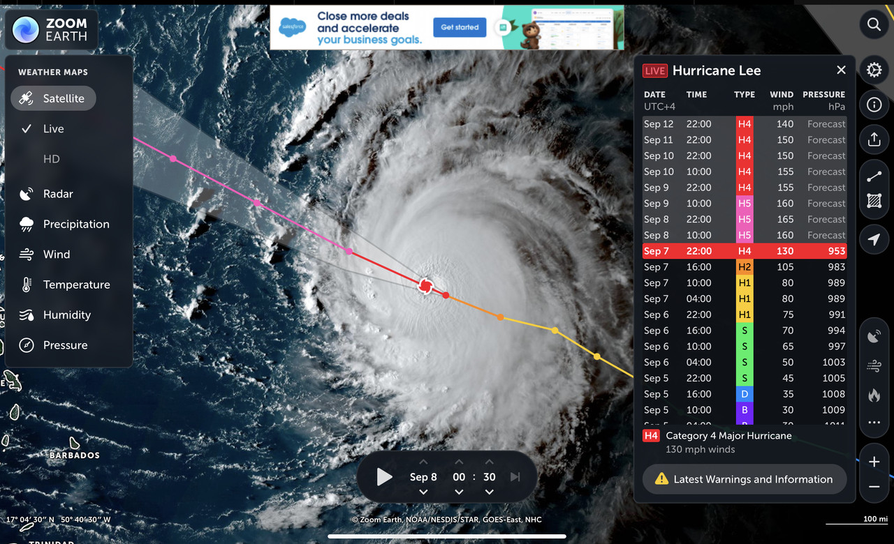
5:00 PM AST Thu Sep 7
Location: 16.9°N 51.3°W
Moving: WNW at 15 mph
Min pressure: 953 mb
Max sustained: 130 mph
...LEE NOW A CATEGORY 4 HURRICANE... ...RIP CURRENTS AND HAZARDOUS SURF WILL SPREAD ACROSS THE NORTHERN CARIBBEAN FRIDAY AND BEGIN AFFECTING THE MAINLAND U.S. BY SUNDAY...
Location: 16.9°N 51.3°W
Moving: WNW at 15 mph
Min pressure: 953 mb
Max sustained: 130 mph
...LEE NOW A CATEGORY 4 HURRICANE... ...RIP CURRENTS AND HAZARDOUS SURF WILL SPREAD ACROSS THE NORTHERN CARIBBEAN FRIDAY AND BEGIN AFFECTING THE MAINLAND U.S. BY SUNDAY...
 1
1

Posted on 9/7/23 at 3:55 pm to lsuman25
FORECAST POSITIONS AND MAX WINDS
INIT 07/2100Z 16.9N 51.3W 115 KT 130 MPH
12H 08/0600Z 17.6N 53.0W 140 KT 160 MPH
24H 08/1800Z 18.7N 55.2W 145 KT 165 MPH
36H 09/0600Z 19.7N 57.2W 140 KT 160 MPH
48H 09/1800Z 20.6N 59.0W 135 KT 155 MPH
60H 10/0600Z 21.3N 60.5W 135 KT 155 MPH
72H 10/1800Z 22.0N 61.8W 130 KT 150 MPH
96H 11/1800Z 23.1N 64.3W 130 KT 150 MPH
120H 12/1800Z 24.0N 66.4W 120 KT 140 MPH

Posted on 9/7/23 at 4:00 pm to lsuman25
Posted on 9/7/23 at 4:01 pm to lsuman25
Confidence remains high in the track for Lee, with almost no change
made to the NHC track forecast. Lee should continue moving
west-northwestward along the southern edge of the subtropical ridge
for the next 5 days. The ridge is forecast to gradually weaken by
early next week, causing Lee to slow down. This track should keep
the core of Lee and its damaging winds north of the Leeward Islands.
There is uncertainty in any northward turn of Lee beginning early
next week, but it is too soon to speculate about specific potential
impacts a week or more out.
Posted on 9/7/23 at 4:03 pm to lsuman25

Posted on 9/7/23 at 4:04 pm to NorthEndZone
Plane en route to Lee

Posted on 9/7/23 at 4:22 pm to lsuman25
quote:
There is uncertainty in any northward turn of Lee beginning early
next week, but it is too soon to speculate about specific potential
impacts a week or more out.
HEAT DOME -


Posted on 9/7/23 at 4:52 pm to TheFonz
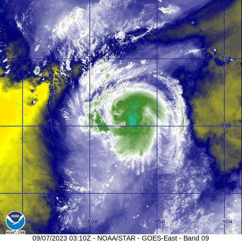
Textbook hurricane.

Posted on 9/7/23 at 4:59 pm to BabysArmHoldingApple
quote:
aka Big Lee
Is there anyone out there that deserves to be dead over baw shite more than Big Lee?
Posted on 9/7/23 at 5:47 pm to Roll Tide Ravens
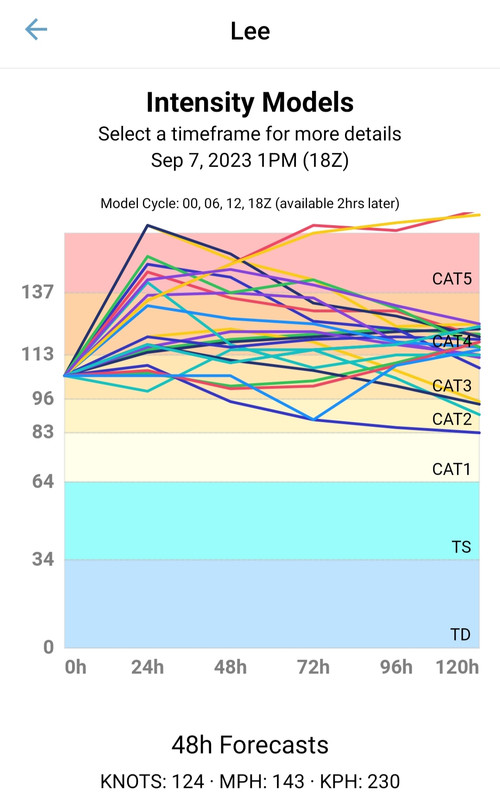
Some intensity models have headed toward a Cat. 6. 
Posted on 9/7/23 at 5:48 pm to McGruff21
OH MY GOD!!
Posted on 9/7/23 at 5:49 pm to McGruff21
If this thing gets big and skirts the each coast, it will still cause damage.
Posted on 9/7/23 at 5:51 pm to LegendInMyMind
Also, earlier today the National Weather Service experienced a "major network issue" that pretty much shut down their satellite imagery feed making it unable to get any satellite imagery. It got fixed, but wow....
Posted on 9/7/23 at 6:15 pm to LegendInMyMind
Cat 6 lady is about to Peacock strut on weather twitter that dragged her yesterday.
Posted on 9/7/23 at 6:19 pm to Roll Tide Ravens
Watch it crank and then see the eye form on mid-level water vapor. That's what ya call perfection.
This post was edited on 9/7/23 at 6:24 pm
Posted on 9/7/23 at 6:20 pm to Lsuhoohoo
The new HAFS models casually dropping a 203 mph mega cane

Posted on 9/7/23 at 6:21 pm to LegendInMyMind
This storm is going to be a monster.
But there is a very strong likelihood it doesn't hit the US. It's tracking to potentially make landfall up in Nova Scotia (obviously weakened by cooler temps).
But there is a very strong likelihood it doesn't hit the US. It's tracking to potentially make landfall up in Nova Scotia (obviously weakened by cooler temps).
Posted on 9/7/23 at 6:25 pm to KosmoCramer
quote:
This storm is going to be a monster.
It already is.

Posted on 9/7/23 at 6:29 pm to NorthEndZone
Bermuda bout to get it?
Posted on 9/7/23 at 6:31 pm to Duke
quote:
Going to be an absolute unit of a hurricane.
Huh, look at that absolute unit of hurricane.

 Page 8 of 18

Popular
Back to top