- My Forums
- Tiger Rant
- LSU Recruiting
- SEC Rant
- Saints Talk
- Pelicans Talk
- More Sports Board
- Winter Olympics
- Fantasy Sports
- Golf Board
- Soccer Board
- O-T Lounge
- Tech Board
- Home/Garden Board
- Outdoor Board
- Health/Fitness Board
- Movie/TV Board
- Book Board
- Music Board
- Political Talk
- Money Talk
- Fark Board
- Gaming Board
- Travel Board
- Food/Drink Board
- Ticket Exchange
- TD Help Board
Customize My Forums- View All Forums
- Show Left Links
- Topic Sort Options
- Trending Topics
- Recent Topics
- Active Topics
Started By
Message
re: Storm Aftermath - Hurricane Matthew will be Retired
Posted on 10/8/16 at 9:53 am to PsychTiger
Posted on 10/8/16 at 9:53 am to PsychTiger
I can already tell people who left are going to try and come back way too soon.
 1
1

Posted on 10/8/16 at 9:56 am to NorthEndZone
quote:
The river crest has been revised upward to greater than the flood of a year ago in Conway, SC.
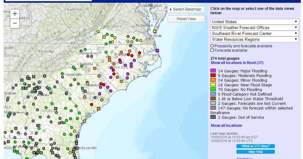
Lots of purple showing up across SC and NC. Anyone that wants to check local gauges the link is here.

Posted on 10/8/16 at 9:58 am to rds dc
Now without power for 5 hours. Saw the transformer explode this morning. 
How is there more outages in lexington and Columbia than down in the lowcountry
How is there more outages in lexington and Columbia than down in the lowcountry

Posted on 10/8/16 at 9:59 am to metallica81788
quote:
I can already tell people who left are going to try and come back way too soon.
I'll come back Monday if the VA is scheduled to be open Tuesday. Otherwise I'm staying away.
Posted on 10/8/16 at 10:04 am to rds dc
Oh lord don't let LSU fans see this image.

Posted on 10/8/16 at 10:05 am to rds dc
Looks like only Hugo and a 1940 hurricane (I assume) topped the river level reached by Matthew. 2 top 5 floods in back to back years.
Historic Crests
(1) 12.52 ft on 09/21/1989
(2) 10.23 ft on 08/11/1940
(3) 9.29 ft on 10/08/2016 (P)
(4) 8.81 ft on 01/01/1987
(5) 8.65 ft on 10/27/2015

Historic Crests
(1) 12.52 ft on 09/21/1989
(2) 10.23 ft on 08/11/1940
(3) 9.29 ft on 10/08/2016 (P)
(4) 8.81 ft on 01/01/1987
(5) 8.65 ft on 10/27/2015

Posted on 10/8/16 at 10:09 am to CtotheVrzrbck
quote:Here's one from yesterday:
Oh lord don't let LSU fans see this image.

71°F / 4mph wind / 0.10" of rain.
Posted on 10/8/16 at 10:13 am to NC_Tigah
Makes them look foolish for not considering a date change to Sunday or Monday.

Posted on 10/8/16 at 10:14 am to NC_Tigah
I heard we had landfall around McCllelenville, SC. It should help break the storm up, right?
Posted on 10/8/16 at 10:16 am to GetCocky11
Did the Angel Oak survive?
Posted on 10/8/16 at 10:17 am to CarolinaGamecock99
Posted on 10/8/16 at 10:28 am to CtotheVrzrbck
Somewhat a thread hijack, but you can see where Alabama is getting no rain. Most of the state is in drought to severe drought conditions.
Surprising that some places are flooding terribly, where not that far away the soils are parched.
Surprising that some places are flooding terribly, where not that far away the soils are parched.
Posted on 10/8/16 at 10:32 am to pennypacker3
"Feel really lucky here in downtown Summerville. No real damage and still with power so far. Hope the rest of the lowcountry people on here fair well."
Y'all have a Walmart over there with a family graveyard out in the front of the parking lot in a median by the Hardees. That is the Jones Family Cemetery and Melville and Susan are my great great grandparents.
My moms side were Charlstonians in the 1700s and spread out to Dorchester and Colleton areas in 1800s.
Posted on 10/8/16 at 10:36 am to NorthEndZone
So the NHC update just abandoned the loop, and pretty much switched from a stand alone system to a system starting to swap to extratropical and will dissipate in 48-72 hours.
The mets really nailed the path of this storm to date, credit for that. But this entire track of this storm from birth to now, just shows how we really are just spitting in the wind when it comes to intensity and internal characteristics of the storm. We just can't predict this very well.
For those of you who are more experienced at this stuff, what do you think it will take to get to a better ability to predict intensity? More computing power? More in-storm sampling? Better satelites? Or is there really nothing more we can do?
Posted on 10/8/16 at 10:43 am to LSUFanHouston
quote:
For those of you who are more experienced at this stuff, what do you think it will take to get to a better ability to predict intensity? More computing power? More in-storm sampling? Better satelites? Or is there really nothing more we can do?
I'm by no means in the know, but there are like a million different factors that go into play. Look how many hurricane prediction tracks there are and I bet everyone of them is better than anything we had 5-10 years ago. They all just use slightly different data and algorithms.
It was still pretty darn accurate and everyone that has been hit so far knew well in advance at least 5 days that it could be coming and to leave.
Posted on 10/8/16 at 10:53 am to tiger91
quote:No. The fact FSU, Miami, and USF are all playing today makes them look foolish.
Makes them look foolish for not considering a date change to Sunday or Monday
Posted on 10/8/16 at 10:57 am to NC_Tigah
Well I have to agree.
Posted on 10/8/16 at 11:18 am to East Coast Band
all we need is a pipeline system for water, transporting the flood water to the drought areas and farmlands.
Create tens of thousands of jobs, suck down flood levels and rehydrate deserts. Limit damages and property losses in one area and turn other areas into income producing areas and reduce the loss of fresh water to the ocean.

Create tens of thousands of jobs, suck down flood levels and rehydrate deserts. Limit damages and property losses in one area and turn other areas into income producing areas and reduce the loss of fresh water to the ocean.
Posted on 10/8/16 at 11:20 am to LSUFanHouston
quote:
The mets really nailed the path of this storm to date, credit for that
yes they did.

 Page 178 of 181

Popular
Back to top