- My Forums
- Tiger Rant
- LSU Recruiting
- SEC Rant
- Saints Talk
- Pelicans Talk
- More Sports Board
- Winter Olympics
- Fantasy Sports
- Golf Board
- Soccer Board
- O-T Lounge
- Tech Board
- Home/Garden Board
- Outdoor Board
- Health/Fitness Board
- Movie/TV Board
- Book Board
- Music Board
- Political Talk
- Money Talk
- Fark Board
- Gaming Board
- Travel Board
- Food/Drink Board
- Ticket Exchange
- TD Help Board
Customize My Forums- View All Forums
- Show Left Links
- Topic Sort Options
- Trending Topics
- Recent Topics
- Active Topics
Started By
Message
re: Tropical Storm Isaias - O Canada!
Posted on 7/23/20 at 8:22 pm to GEAUXmedic
Posted on 7/23/20 at 8:22 pm to GEAUXmedic
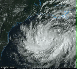
looks like a center of circulation is trying to clear out
 1
1

Posted on 7/23/20 at 9:01 pm to rt3
quote:
looks like a center of circulation is trying to clear out
Too early for a true eye feature. It is building a nice band on the southside and starting to wrap it around the east. That's what it needs for the next step. Have enough wind near the center to sustain that convection, which will help get more wind near the center and so on. Once that banding gets wrapped fully around the strengthening will really being. Pressure still dropping tonight, but another big arse circulation in the gulf taking awhile to come together.
Going to be strengthening into landfall and a strong TS making a run at hurricane at landfall will surprise you. Ask New Orleans with Cindy in 2005.
Posted on 7/23/20 at 9:03 pm to Roll Tide Ravens
Exactly, Meh like it doesn't rain here already
Posted on 7/23/20 at 9:09 pm to Duke
It has been interesting to watch over the past 3 days or so. From just a blob of storms floating around to starting to take shape now.

Posted on 7/23/20 at 9:12 pm to LegendInMyMind
Pressure down to 1002, it's so large it'll take a bit for that to translate to higher winds, but I'd definitely bank on having a TS by morning.

Posted on 7/23/20 at 9:14 pm to Duke
quote:
Going to be strengthening into landfall and a strong TS making a run at hurricane at landfall will surprise you. Ask New Orleans with Cindy in 2005.
For the Texas landfall this one will be more like Claudette in 2003.
Posted on 7/23/20 at 9:19 pm to LegendInMyMind
quote:
It has been interesting to watch over the past 3 days or so. From just a blob of storms floating around to starting to take shape now.
Once that upper low dipped off to the SW and the shear dropped off it, it's been an interesting watch. Really enjoy watching this process from just a patch of thunderstorms to a damn nice curved band forming up. Take heat, make structure.
Posted on 7/23/20 at 9:20 pm to GEAUXmedic
TD8’looks more organized than Tropical Storm Gonzalo

Posted on 7/23/20 at 9:23 pm to deltaland
I'm amazed the national media isn't all over this like they usually are. 
Posted on 7/23/20 at 9:37 pm to Duke
quote:
Too early for a true eye feature.
why I purposely said "center of circulation" instead of "eye"
but just a way of saying the circulation is going from a broad low to a tighter circulation and finding its true center
I know it has a long way to go to have a clear "eye"... but at least seemed like the center is getting better defined
Posted on 7/23/20 at 9:45 pm to rt3
Looks like they found some Tropical Storm winds
Posted on 7/23/20 at 9:46 pm to rt3
quote:
I know it has a long way to go to have a clear "eye"... but at least seemed like the center is getting better defined
Gotcha.
And you're absolutely right.
Posted on 7/23/20 at 9:52 pm to lsuman25
quote:
Looks like they found some Tropical Storm winds
34-40 kt winds now being found at flight level near the center of circulation
peak 10 second wind is currently 31 knots... 35 mph
Posted on 7/23/20 at 9:52 pm to rds dc
Impressively large circulation but that should keep it from wrapping up too fast.

Posted on 7/23/20 at 9:53 pm to Duke
quote:
Gotcha.
And you're absolutely right.
I would hope my reputation in these threads isn't "fear mongerer" or "wishcaster"
just someone who provides official information and quality observations
with some witty quips at time
Posted on 7/23/20 at 9:58 pm to rt3
...AIR FORCE HURRICANE HUNTERS FIND THAT THE GULF DEPRESSION HAS STRENGTHENED INTO TROPICAL STORM HANNA... ...TROPICAL STORM WARNING EXTENDED SOUTHWARD...
10:00 PM CDT Thu Jul 23
Location: 26.2°N 91.4°W
Moving: WNW at 7 mph
Min pressure: 1002 mb
Max sustained: 40 mph
10:00 PM CDT Thu Jul 23
Location: 26.2°N 91.4°W
Moving: WNW at 7 mph
Min pressure: 1002 mb
Max sustained: 40 mph
Posted on 7/23/20 at 10:00 pm to rt3
quote:
I would hope my reputation in these threads isn't "fear mongerer" or "wishcaster"
just someone who provides official information and quality observations
You assume I was paying attention to who I was responding to.
Posted on 7/23/20 at 10:02 pm to Duke
quote:
You assume I was paying attention to who I was responding to.
just don't want to be "that guy"
Posted on 7/23/20 at 10:07 pm to lsuman25
quote:
TROPICAL STORM HANNA
Earliest 8th named storm moving ahead of 2005 but 2005 had already produced 2 major hurricanes by this point.

Posted on 7/23/20 at 10:19 pm to rds dc
quote:
Hanna

 Page 12 of 50

Popular
Back to top