- My Forums
- Tiger Rant
- LSU Recruiting
- SEC Rant
- Saints Talk
- Pelicans Talk
- More Sports Board
- Winter Olympics
- Fantasy Sports
- Golf Board
- Soccer Board
- O-T Lounge
- Tech Board
- Home/Garden Board
- Outdoor Board
- Health/Fitness Board
- Movie/TV Board
- Book Board
- Music Board
- Political Talk
- Money Talk
- Fark Board
- Gaming Board
- Travel Board
- Food/Drink Board
- Ticket Exchange
- TD Help Board
Customize My Forums- View All Forums
- Show Left Links
- Topic Sort Options
- Trending Topics
- Recent Topics
- Active Topics
Started By
Message
re: Tropical Storm Isaias - O Canada!
Posted on 7/23/20 at 10:35 pm to Bobby OG Johnson
Posted on 7/23/20 at 10:35 pm to Bobby OG Johnson
think we all need to be happy that Hanna doesn't have like 2-3 more days over open water
 2
2


Posted on 7/23/20 at 11:28 pm to rt3
As someone that lost our place in Rockport to Harvey you are correct. Might go rub on the blue shed tomorrow for some good luck 
Posted on 7/23/20 at 11:33 pm to rds dc
quote:
Impressively large circulation
How is this measured? Where does Hanna start and stop?
Posted on 7/24/20 at 2:32 am to rt3
quote:
with some witty quips at time
Ehhhhh....

Posted on 7/24/20 at 4:10 am to Duke
quote:
making a run at hurricane at landfall will surprise you. Ask New Orleans with Cindy in 2005.
Humberto, 2007
quote:
Hurricane Humberto was a Category 1 hurricane that formed and intensified faster than any other North Atlantic tropical cyclone on record, before landfall. Developing on September 12, 2007, in the northwestern Gulf of Mexico, the tropical cyclone rapidly strengthened and struck High Island, Texas, with winds of about 90 mph (150 km/h) early on September 13. It steadily weakened after moving ashore, and on September 14, Humberto began dissipating over northwestern Georgia as it interacted with an approaching cold front.
quote:
Based on operational estimates of a wind speed increase of 50 mph (85 km/h), the National Hurricane Center reported that "no tropical cyclone in the historic record has ever reached this intensity at a faster rate near landfall."
I remember it well. Was in Baltimore working and had to fly back to Houston that night. When we got to the airport in Baltimore, it was nothing more than a few rain showers. By the time I was driving home to Lake Charles from Houston at 11pm, I was driving through the outer bans of a hurricane.
Outside of being a south Louisiana driver driving in a moderate snowstorm down the mountains back into Denver on I-70, driving back through that thing in the middle of the night was the most nervous I ever have been behind the wheel of a car.
This post was edited on 7/24/20 at 4:21 am

Posted on 7/24/20 at 5:37 am to Prominentwon


Posted on 7/24/20 at 6:36 am to deltaland
Hanna looking healthy this morning
Gonzalo can’t get his act together
Gonzalo can’t get his act together
Posted on 7/24/20 at 6:58 am to deltaland
...NOAA HURRICANE HUNTERS FIND HANNA A LITTLE FARTHER NORTH...
7:00 AM CDT Fri Jul 24
Location: 27.1°N 92.8°W
Moving: WNW at 9 mph
Min pressure: 1001 mb
Max sustained: 40 mph
7:00 AM CDT Fri Jul 24
Location: 27.1°N 92.8°W
Moving: WNW at 9 mph
Min pressure: 1001 mb
Max sustained: 40 mph
Posted on 7/24/20 at 7:13 am to deltaland
quote:
Hanna looking healthy this morning
Still a pretty sizable lack of convection from 8 o'clock to about 1 o'clock - a little more than the entire NW quadrant.
Posted on 7/24/20 at 7:29 am to rt3
quote:
think we all need to be happy that Hanna doesn't have like 2-3 more days over open water
Why? the more it tightens up the less rain we get
South Texas needs to be happy it doesn't have more time over water

Posted on 7/24/20 at 7:37 am to Prominentwon
quote:
Outside of being a south Louisiana driver driving in a moderate snowstorm down the mountains back into Denver on I-70
Did this (from Breck) last December.
Posted on 7/24/20 at 8:22 am to Roll Tide Ravens
quote:
Sea surface temps in the Gulf are generally around 86°F:
Seems they were this warm in Jan
Posted on 7/24/20 at 8:53 am to slackster
quote:
Still a pretty sizable lack of convection from 8 o'clock to about 1 o'clock - a little more than the entire NW quadrant.
Yep. Didn't wrap it around last night and is a little lopsided this morning to the south. Pressure still falling, last pass was 999 but still lacking symmetric organization.
Posted on 7/24/20 at 9:11 am to Midtiger farm
quote:
Why? the more it tightens up the less rain we get
South Texas needs to be happy it doesn't have more time over water
b/c no one wants to see a major hurricane make landfall... and it seems like if Hanna had 2 or 3 more days than currently forecast then it would be able to be just that

Posted on 7/24/20 at 9:28 am to rt3
Y’all don’t get too carried away with Hannah and Gonzalo. You won’t have any energy left to track this potential EURO beast next weekend...


Posted on 7/24/20 at 9:39 am to TDsngumbo
Pucker factor monitor: Engaged

Posted on 7/24/20 at 9:39 am to TDsngumbo
If the Euro duplicates that on tomorrow's runs I'll start getting concerned.
Posted on 7/24/20 at 9:44 am to Zephyrius
Previous run had the same strong storm going north of cuba. Before that hitting the island and breaking up.
It has been consistent with a strong storm. Just need to see about direction.
It has been consistent with a strong storm. Just need to see about direction.
Posted on 7/24/20 at 9:55 am to BallsEleven
quote:
Previous run had the same strong storm going north of cuba. Before that hitting the island and breaking up.
It has been consistent with a strong storm. Just need to see about direction.
Yep, might be time for me to renew my subscription to the complete EURO runs so I can glue myself to it and get absolutely nothing accomplished at work
Posted on 7/24/20 at 10:02 am to TDsngumbo
quote:
BULLETIN
Tropical Storm Hanna Advisory Number 7
NWS National Hurricane Center Miami FL AL082020
1000 AM CDT Fri Jul 24 2020
...NOAA HURRICANE HUNTER AIRCRAFT AND SHIP REPORTS INDICATE HANNA
HAS STRENGTHENED A LITTLE...
...TROPICAL STORM WATCH DISCONTINUED...
SUMMARY OF 1000 AM CDT...1500 UTC...INFORMATION
-----------------------------------------------
LOCATION...27.2N 93.2W
ABOUT 260 MI...420 KM E OF CORPUS CHRISTI TEXAS
ABOUT 260 MI...420 KM E OF PORT MANSFIELD TEXAS
MAXIMUM SUSTAINED WINDS...45 MPH...75 KM/H
PRESENT MOVEMENT...WNW OR 285 DEGREES AT 9 MPH...15 KM/H
MINIMUM CENTRAL PRESSURE...1000 MB...29.53 INCHES
WATCHES AND WARNINGS
--------------------
CHANGES WITH THIS ADVISORY:
The Tropical Storm Watch from San Luis Pass to High Island Texas
has been discontinued.
SUMMARY OF WATCHES AND WARNINGS IN EFFECT:
A Tropical Storm Warning is in effect for...
* Mouth of the Rio Grande to San Luis Pass Texas
A Tropical Storm Warning means that tropical storm conditions are
expected somewhere within the warning area, in this case within 24
to 36 hours.
Interests along the Texas and Louisiana coast should monitor the
progress of this system.
For storm information specific to your area, including possible
inland watches and warnings, please monitor products issued by your
local National Weather Service forecast office.
DISCUSSION AND OUTLOOK
----------------------
At 1000 AM CDT (1500 UTC), the center of Tropical Storm Hanna was
located by NOAA reconnaissance aircraft near latitude 27.2 North,
longitude 93.2 West. Hanna is moving toward the west-northwest near
9 mph (15 km/h), and this motion should continue today. A turn
toward the west is expected tonight, followed by a westward to
west-southwestward motion through the weekend. On the forecast
track, center of Hanna should make landfall along the Texas coast
within the warning area Saturday afternoon or evening.
Maximum sustained winds have increased to near 45 mph (75 km/h)
with higher gusts. Gradual strengthening is expected until the
tropical cyclone makes landfall. Steady weakening is expected after
Hanna moves inland.
Tropical-storm-force winds extend outward up to 60 miles (95 km)
from the center. During the past few hours, a ship located east of
the center reported a sustained wind of 44 mph (70 km/h).
Reports from the NOAA reconnaissance aircraft indicate that the
minimum central pressure is 1000 mb (29.53 inches).
HAZARDS AFFECTING LAND
----------------------
Key messages for Tropical Storm Hanna can be found in the
Tropical Cyclone Discussion under AWIPS header MIATCDAT3 and WMO
header WTNT43 KNHC.
WIND: Tropical storm conditions are expected in the warning area
by tonight or Saturday morning.
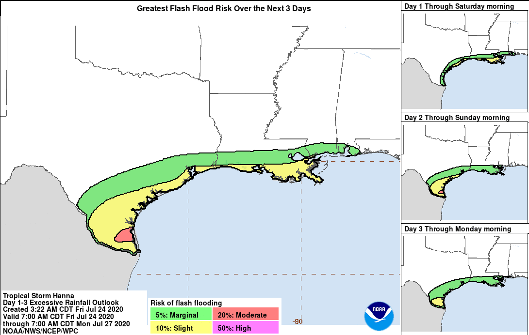
RAINFALL: Hanna is expected to produce 4 to 8 inches of rain with
isolated maximum totals of 12 inches through Sunday night in south
Texas. This rain may result in life-threatening flash flooding,
rapid rises on small streams, and isolated minor to moderate river
flooding in south Texas.
3 to 5 inches of rain is expected along the upper Texas and
Louisiana coasts, and inland to the Mexican states of Coahuila,
Nuevo Leon, and northern Tamaulipas.
STORM SURGE: The combination of storm surge and the tide will cause
normally dry areas near the coast to be flooded by rising waters
moving inland from the shoreline. The water could reach the
following heights above ground somewhere in the indicated areas if
the peak surge occurs at the time of high tide...
Mouth of the Rio Grande to High Island including Corpus Christi Bay,
Matagorda Bay, and Galveston Bay...1-3 ft
The deepest water will occur along the immediate coast near and to
the right of the landfall location. Surge-related flooding depends
on the relative timing of the surge and the tidal cycle, and can
vary greatly over short distances. For information specific to
your area, please see products issued by your local National
Weather Service forecast office.
SURF: Swells generated by Hanna are expected to increase and affect
much of the Texas and Louisiana coasts during the next few days.
These swells are likely to cause life-threatening surf and rip
current conditions. Please consult products from your local weather
office.
NEXT ADVISORY
-------------
Next intermediate advisory at 100 PM CDT.
Next complete advisory at 400 PM CDT.
$$
Forecaster Stewart

 Page 13 of 50

Popular
Back to top