- My Forums
- Tiger Rant
- LSU Recruiting
- SEC Rant
- Saints Talk
- Pelicans Talk
- More Sports Board
- Winter Olympics
- Fantasy Sports
- Golf Board
- Soccer Board
- O-T Lounge
- Tech Board
- Home/Garden Board
- Outdoor Board
- Health/Fitness Board
- Movie/TV Board
- Book Board
- Music Board
- Political Talk
- Money Talk
- Fark Board
- Gaming Board
- Travel Board
- Food/Drink Board
- Ticket Exchange
- TD Help Board
Customize My Forums- View All Forums
- Show Left Links
- Topic Sort Options
- Trending Topics
- Recent Topics
- Active Topics
Started By
Message

 0
0


Posted on 8/21/15 at 10:25 am to TDsngumbo
quote:
PUBLIC ADVISORY 11:00AM EST
quote:
...Danny strengthens into a category 2 hurricane...
Summary of 1100 am AST...1500 UTC...information
-----------------------------------------------
location...14.0n 48.2w
about 930 mi...1495 km E of the Leeward Islands
maximum sustained winds...105 mph...165 km/h
present movement...WNW or 290 degrees at 10 mph...17 km/h
minimum central pressure...976 mb...28.82 inches
Watches and warnings
--------------------
there are no coastal watches or warnings in effect.
Interests in the Leeward Islands should monitor the progress of
Danny.
Discussion and 48-hour outlook
------------------------------
at 1100 am AST (1500 utc), the center of Hurricane Danny was located
near latitude 14.0 north, longitude 48.2 west. Danny is moving
toward the west-northwest near 10 mph (17 km/h), and this motion is
expected to continue through tonight. A turn toward the west is
expected on Saturday or Saturday night.
Maximum sustained winds have increased to near 105 mph (165 km/h)
with higher gusts. Danny is about to encounter a less conducive
environment, and weakening is forecast during the next 48 hours. A
NOAA hurricane hunter aircraft is scheduled to investigate Danny
late this afternoon.
Danny remains a tiny hurricane. Hurricane force winds extend
outward up to 15 miles (30 km) from the center and tropical storm
force winds extend outward up to 70 miles (110 km).
The estimated minimum central pressure is 976 mb (28.82 inches).
DISCUSSION
quote:
Danny has continued to strengthen during the past several hours.
The small eye has become better defined, and it is now embedded in
a circular central dense overcast. In addition, the ragged outer
banding has increased in coverage and now surrounds the central
convection. The initial intensity is increased to 90 kt in
agreement with satellite intensity estimates from TAFB and SAB. It
is notable that experimental multispectral Meteosat imagery suggests
that low-level moisture has wrapped around the cyclone and pushed
the drier air farther away. This could be helping both the
intensification and the increase in outer banding.
The initial motion is 290/9. The subtropical ridge north of Danny
remains weaker than normal due to a deep-layer trough over the
western Atlantic. This trough is expected to lift northward in a
couple of days, allowing the ridge to build westward and
strengthen. This evolution should cause Danny to turn more
westward with some increase in forward speed. The track guidance
is in good agreement with this scenario and forecasts Danny to be
near the Leeward Islands in about 72 hours, near Puerto Rico in
about 96 hours, and near Hispaniola in about 120 hours. The new
forecast track, which is in best agreement with the GFS and ECMWF
models, lies close to the previous forecast through 96 hours and a
little to the north of the previous forecast at 120 hours.
Danny is currently in an environment of light vertical wind shear.
However, it is about to encounter increasing upper-level
southwesterly flow associated with a trough over the northeastern
Caribbean, with the shear forecast to increase to over 20 kt by 96
hours. This, combined with the abundant dry air remaining along the
forecast track, should cause Danny to weaken below hurricane
strength as it approaches the Caribbean islands. The new intensity
forecast is a little stronger than the intensity consensus through
96 hours. After that, it is weaker than most of the guidance due
to the expected interaction with land.
A NOAA aircraft will be conducting a research mission in and around
Danny this afternoon, and an Air Force Reserve unit reconnaissance
aircraft will investigate Danny Saturday afternoon. These data
will provide a better assessment of the intensity and structure of
the hurricane.
Forecast positions and Max winds
Init 21/1500z 14.0n 48.2w 90 kt 105 mph
12h 22/0000z 14.5n 49.6w 90 kt 105 mph
24h 22/1200z 15.1n 51.7w 85 kt 100 mph
36h 23/0000z 15.5n 54.0w 75 kt 85 mph
48h 23/1200z 16.0n 56.4w 65 kt 75 mph
72h 24/1200z 17.0n 61.5w 55 kt 65 mph
96h 25/1200z 18.0n 66.0w 50 kt 60 mph
120h 26/1200z 19.5n 71.0w 40 kt 45 mph...inland
I anticipate this thread to die out when Danny falls below hurricane strength. Let us not forget that Hurricane Katrina started out as a tropical depression that fell apart to a tropical wave. Once it got to the Bahamas, it strengthened into a tropical storm, then hurricane, then hit Florida. Once it emerged into the Gulf of Mexico, it became a monster.
Nobody wants a monster hurricane. Pay attention to Danny, folks. He has lots of obstacles to jump through but his new forecast track does take him though the path of least resistance now, and then on a more westward track. Common sense says a more westward track, while it's already north of the Caribbean, takes it over southern Florida and into the Gulf around the periphery of the Atlantic ridge. If Danny survives, the southeastern United States needs to pay close attention to it.
Posted on 8/21/15 at 10:27 am to TDsngumbo
Also, I just stole this from another forum. It perfectly illustrates the obstacles Danny's about to encounter. Expect this hurricane to get a beat down like a minority during a traffic stop very shortly:

This post was edited on 8/21/15 at 10:29 am
Posted on 8/21/15 at 10:29 am to TDsngumbo
Posted on 8/21/15 at 10:31 am to TDsngumbo
i think danny survives all ods ahead

Posted on 8/21/15 at 10:33 am to Chad504boy
quote:
ods
Overly Dry Shear?

Posted on 8/21/15 at 10:33 am to TDsngumbo
Posted on 8/21/15 at 10:36 am to Chad504boy
quote:
i think danny survives all ods ahead
That's gonna be hard to do. He's going to experience a beat down for sure. Question is will it be enough to permanently do him in? I personally think there will still be a little bit left of him but I'm not paid to do what I do.
Posted on 8/21/15 at 10:40 am to TDsngumbo
Do we have to copy and paste the entire article?
Brevity.
Look it up.
Learn it.
Brevity.
Look it up.
Learn it.
Posted on 8/21/15 at 10:40 am to TDsngumbo
ods are u might be right, some ods might be wrong though.
Posted on 8/21/15 at 10:43 am to Chad504boy
quote:
ods are u might be right, some ods might be wrong though.
We got it, odds was incorrectly spelled. Awesome job pointing it out. Now let's get back on track, is football season in Louisiana still happening?
Posted on 8/21/15 at 10:48 am to N2cars
quote:
Do we have to copy and paste the entire article?
Brevity.
Look it up.
Learn it.
I'm sorry, I didn't realize I was being insensitive to the ADHD/ADD crowd here.

Posted on 8/21/15 at 10:48 am to TDsngumbo
quote:
It perfectly illustrates the obstacles Danny's about to encounter. Expect this hurricane to get a beat down like a minority during a traffic stop very shortly:
Danny about to get dry fricked out of existence.

Posted on 8/21/15 at 10:50 am to GeorgeTheGreek
quote:
My wife is ok with it. Open relationship.
Posted on 8/21/15 at 10:50 am to TDsngumbo
Posted on 8/21/15 at 11:14 am to musick
If he survives and misses the mountains of Hispaniola more north he might have a shot
Other than that he has his work cut out for him
Other than that he has his work cut out for him

Posted on 8/21/15 at 11:19 am to Mullet Flap
Sorry to burst y'all's bubble, but danny is coming over to my house for a bbq in about a week. I can't wait.
Posted on 8/21/15 at 11:23 am to tigersownall
quote:
orry to burst y'all's bubble, but danny is coming over to my house for a bbq in about a week
WTF --- where the hell was our invitation? You can't mention a bbq to the OT if you don't have enough to share with the rest of us.
This post was edited on 8/21/15 at 11:24 am
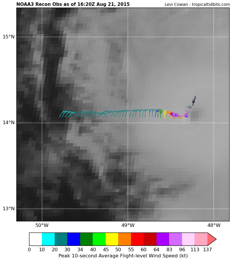
Posted on 8/21/15 at 11:35 am to TDsngumbo
quote:
Dave Nussbaum WWL-TV ?@Dave_Nussbaum
NOAA3 Mission recon is flying into #Danny now. They are recording strong winds & lower pressure.

 Page 23 of 30

Popular
Back to top