- My Forums
- Tiger Rant
- LSU Recruiting
- SEC Rant
- Saints Talk
- Pelicans Talk
- More Sports Board
- Winter Olympics
- Fantasy Sports
- Golf Board
- Soccer Board
- O-T Lounge
- Tech Board
- Home/Garden Board
- Outdoor Board
- Health/Fitness Board
- Movie/TV Board
- Book Board
- Music Board
- Political Talk
- Money Talk
- Fark Board
- Gaming Board
- Travel Board
- Food/Drink Board
- Ticket Exchange
- TD Help Board
Customize My Forums- View All Forums
- Show Left Links
- Topic Sort Options
- Trending Topics
- Recent Topics
- Active Topics
Started By
Message
re: Hurricane Dorian - Headed to Canada
Posted on 9/4/19 at 8:36 am to Centinel
Posted on 9/4/19 at 8:36 am to Centinel
quote:
I don't remember any of the others storms the past few years having that sharp of a differentiation between getting nothing and experiencing heavy rain/wind.
Size and path will do it. It happens though.
Look at Michael last October. Panama City Beach, TS conditions, not too bad. Panama City proper? I'm sure there are still blue tarps on roofs after getting Cat 3 conditions.
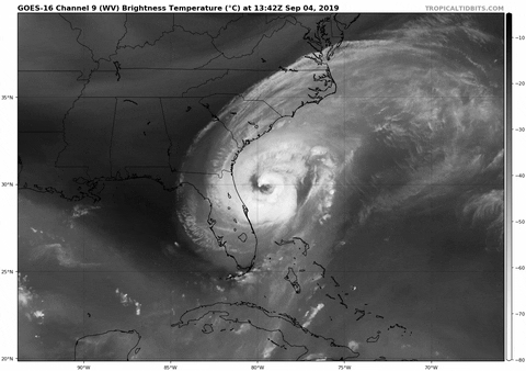
Microwave pass this morning shows a pretty healthy core for Dorian, especially on the west side. If it's enough for a proper eye to reform, it's gonna be pretty huge. Dorian would look like an oblong truck tire.
This post was edited on 9/4/19 at 8:42 am
 2
2


Posted on 9/4/19 at 8:41 am to Duke
Yeah 10 miles or so can make a HUGE difference.
Posted on 9/4/19 at 8:52 am to Duke
quote:
I'm sure there are still blue tarps on roofs after getting Cat 3 conditions.
Bruh, they got a hell of a lot worse then Cat 3 in Rutherford and Panama City proper. Given a lot of it was run down and old, but there’s still businesses like multiple Burger Kings shut down. Entire strip malls have walls missing. Blue tarp roofs were the lucky ones, missing roof and missing walls and entire structures leveled was very routine.
You are correct though, 5-15 miles away and you really don’t even know a hurricane hit in Panama City Beach.
Posted on 9/4/19 at 8:54 am to baldona
quote:
Bruh, they got a hell of a lot worse then Cat 3 in Rutherford and Panama City proper.
I think you underestimate Category 3 conditions.

Posted on 9/4/19 at 9:12 am to baldona
quote:
5-15 miles away and you really don’t even know a hurricane hit in Panama City Beach.
This. We went to a wedding that weekend in Sandestin and it was beautiful and slick calm. I kind of felt guilty relaxing on the beach drinking knowing the destruction that just occurred 2 days prior right down the road. We did bring some cases of water/food from Louisiana though.

Posted on 9/4/19 at 9:21 am to Duke
quote:
As far as I can tell, the core of Dorian is just off shore this morning. Hopefully for Jacksonville and southern Georgia it stays that way.
The Carolinas aren't likely to get as lucky.
Appears to already be turning NE.

Posted on 9/4/19 at 9:31 am to Duke
changed already just went back to a Cat2 from a Cat1 in NC
This post was edited on 9/4/19 at 10:03 am
Posted on 9/4/19 at 9:32 am to redneck
From Sydney Torres:
I have two of my DC 3 cargo planes going down to the Bahamas Saturday and Sunday full of food and medical supplies.
please anyone in the medical field can assist with assembling triage on a pallet containing these items we will be shipping out the 18 wheelers from my office in mid city Friday Saturday and Sunday.
They will be delivered to the cargo planes in South Florida and be on the ground in the Bahamas for this weekend.
If anyone can help please send me a message on Facebook as I usually don’t check but I will for this occasion.
Thank you!
From the government
Message from Abaco Clinic
DIRE NEED OF MEDICAL Supplies
Attached - full report from team on ground:
INSTEAD OF BACK BOARDS, any folding stretchers?
We have most of other kit requested w exception tetanus shots
Abaco Clinic initial assessment.
Current situation at clinic has mitigated any critical patient, procedure and no immediate evacuation needed. However, 15 patients are arriving every day, with 0 – 1 patient each evening. Rescue efforts are still active and much of the island has not been accessed. This is resulting in sporadic critical patient arrivals. Up to this point critical patients have been poly trauma with 3 amputations, not assisted by providers.
Hospital is running on generator power as needed and at nights.
The hospital has 1500 people in it as a shelter with a small 3 bed clinic for patients to be seen. Approx. 30 helicopter evacuations have been completed. L&D has one room for use.
X-ray machine is believed to work, just no one knows how to and need a tech. Currently it is being used as cooking area.
Basic Labs may be drawn, but the lab has been compromised by the hurricane and is running low on supplies. The draws are critical need only.
They can take a 12 lead, but it is not standard. Unknown on system.
They are considering on staffing in shifts.
All potential urgent or worse medical patients are being evaluated and flown out. They have no communication with evac crews. They are just waiting to see when they arrive then wave down the helicopter and drive people out in the ambulance.
No pending procedures on island.
One newborn known at 1-2 weeks. One expecting at 7 months pregnant. One deliver completed and evacuated already.
Future concerns of Attending is the continuation of treatment of scrapes/bumps/bruises. With general illness and chronic medical conditions being non-compliant with meds will be bringing medical issues to the surface. Primary is Insulin, Dialysis etc. Major traumas still arriving.
The following have no urgent need: Dental Optomology, oncology, OB/GYN.
There is no EMS response at this time despite 2 running ambulances. Their third ambulance is damaged beyond use. There is a medical staff of the following:
MD 3
Nurse 7
EMT 7
Fire/rescue is volunteer only and dispersed at this time. The fire department has been looted and usable items have been secured at the hospital.
Mental health is significant need. The staff admits they would like to talk with a therapist. All medical staff are already emotionally discussing what they have seen with me.
EMS is requesting the following.
- Back boards
- C-collars
- Exam gloves
- IV fluid Sodium chloride
- IV fluid Lactated ringer
- IV fluid 5% dextrose
- Alcohol prep pads
- Hydrogen peroxide
- Sam splint
- Oxygen tanks (Vehicle/D)
- LMA all sizes
- BP cuffs
- AED pads
- Suction cathedars
- Pain medication (OTC)
- Anti-acid
- Benadryl PO
- Glucose
- Glucometer
- Non-rebreather masks
- Sodium chorlied irrigation
- Adhesive bandages all sizes, Particularly Finger and knuckle
- Pressure bandages
- Tourniquets
- Surgical sponges
- Provider face masks(isolation mouth, nose eyes)
- OPA all sizes
- NPA all sizes
- Life band for Auto pulse
- Head block kits for backboard
- Back board strips
- Finger pulse oximetry
- Pediatric pulse oximetry
- Surface disinfectant and cavi wipes
- Electrodes for EKG Zoll X-series monitor
- Blue bed pads
- Rain gear
- Water boots
- Oxygen regulators
- Bleach
- Laryngoscope blades
- HAND SANITIZER
Clinic Requests
- Meds
o Ventalin Inhaler
o Dicrofenac Injection
o Bracgin Injection
o Paracetamos ttabs
o Childrens Ibuprophen
o Childerens Dimenhyrinate
o Childrens Loratadine
o ORS
o Preterax 5mg and 10mg
o Amlodipine 5mg 10mg
o Janumez 50/500 & 50/1000
o Dicrofenac Gel
o Bacreocin Opintement
o Schederma Cream
o Alcohol prep pads
o Profidine Solution
o Hydrocortisone cream
o Benztropine 2mg
o Depicocl 20mginj
o Prednisone 5mg tabs
o Jprednisone 10mg tabs
o Ibrupohen 600 mg
o Voltren 75mg
o Arcoxias 60mg 90mg
o Filexerol 5mg 10mg
o Paper bed rolls
- Fluids
o NS IV 1L
o 500 IV NS 500ml
o 100 ml NS
o Suture trays
o Unsterile gauze
o Sterile gauze
o Synthroid 50 mg
o Sythroid 100mg
o Cephaflexin
o Lacoten croforne
o Tobrex
o Tobradex
o Vigamax
o Nasonex
o Dtritine
o Pataday
o Alstifical teace
o Bisofzfron
o Non -rebreaher mask
o Suture
? Medsilk 3,2,4,5,
? Prolene 2,3,4,5
? Blue bads
o Tetansu einj
o Dtap inj
- Face masks
- N95
- Hand sanitizer
ALL needs for hygeine especially female products
Posted on 9/4/19 at 9:33 am to bigberg2000
quote:
Yeah 10 miles or so can make a HUGE difference.
saw that with harvey
major damage in rockport & port A, port oconnor pretty much spared, but major damage in port lavaca
Posted on 9/4/19 at 9:55 am to cajunangelle
Poor Charleston, SC. The storm surge is going to be brutal because this sucker is pushing more water than is typical for a Cat 2.
Posted on 9/4/19 at 9:56 am to tgrbaitn08
quote:
DC 3 cargo planes
Why in the world would he have DC 3s?
That's kinda neat though
Posted on 9/4/19 at 9:56 am to cajunangelle
quote:
Can anyone confirm this?
confirm what?
Posted on 9/4/19 at 10:00 am to GEAUXT
quote:
Why in the world would he have DC 3s?
That's kinda neat though
He rented the DC 3s he doesn't own any of those.
Posted on 9/4/19 at 10:00 am to rds dc
NW quadrant winds are ones the will affect coastline.
HURRICANE CENTER LOCATED NEAR 29.8N 79.7W AT 04/1500Z
POSITION ACCURATE WITHIN 20 NM
PRESENT MOVEMENT TOWARD THE NORTH-NORTHWEST OR 335 DEGREES AT 8 KT
ESTIMATED MINIMUM CENTRAL PRESSURE 964 MB
EYE DIAMETER 55 NM
MAX SUSTAINED WINDS 90 KT WITH GUSTS TO 110 KT.
64 KT....... 60NE 40SE 40SW 50NW.
50 KT.......100NE 80SE 60SW 90NW.
34 KT.......150NE 130SE 100SW 140NW.
12 FT SEAS..270NE 240SE 210SW 180NW.
WINDS AND SEAS VARY GREATLY IN EACH QUADRANT. RADII IN NAUTICAL
MILES ARE THE LARGEST RADII EXPECTED ANYWHERE IN THAT QUADRANT.
REPEAT...CENTER LOCATED NEAR 29.8N 79.7W AT 04/1500Z
AT 04/1200Z CENTER WAS LOCATED NEAR 29.5N 79.6W
FORECAST VALID 05/0000Z 30.8N 80.0W
MAX WIND 90 KT...GUSTS 110 KT.
64 KT... 60NE 50SE 40SW 50NW.
50 KT...100NE 70SE 60SW 90NW.
34 KT...160NE 140SE 100SW 130NW.
FORECAST VALID 05/1200Z 31.9N 79.8W
MAX WIND 85 KT...GUSTS 105 KT.
64 KT... 60NE 50SE 40SW 50NW.
50 KT... 80NE 80SE 60SW 70NW.
34 KT...160NE 140SE 100SW 110NW.
FORECAST VALID 06/0000Z 33.1N 78.6W
MAX WIND 85 KT...GUSTS 105 KT.
64 KT... 50NE 50SE 40SW 50NW.
50 KT... 80NE 80SE 60SW 60NW.
34 KT...160NE 160SE 110SW 100NW.
FORECAST VALID 06/1200Z 34.8N 76.4W
MAX WIND 85 KT...GUSTS 105 KT.
64 KT... 50NE 50SE 40SW 50NW.
50 KT... 80NE 80SE 60SW 70NW.
34 KT...160NE 160SE 120SW 90NW.
FORECAST VALID 07/1200Z 39.9N 68.2W
MAX WIND 75 KT...GUSTS 90 KT.
50 KT...100NE 100SE 80SW 80NW.
34 KT...220NE 200SE 180SW 170NW.
EXTENDED OUTLOOK. NOTE...ERRORS FOR TRACK HAVE AVERAGED NEAR 150 NM
ON DAY 4 AND 175 NM ON DAY 5...AND FOR INTENSITY NEAR 15 KT EACH DAY
Posted on 9/4/19 at 10:13 am to NorthEndZone
Why won’t these shitheads show a track that focuses in on the US instead of zooming way out? Why do we care about a week from now in the ocean?
Posted on 9/4/19 at 10:15 am to cajunangelle
quote:
Appears to already be turning NE.
Pegged at NNW by the NHC. Radar out of Savannah agrees.
quote:
Locally in Coastal NC I heard landfall in Morehead City Jacksonville NC, as well as Cape Fear or Cape Fear lookout and now possibly SC. Very vague. I suppose by this evening it won't be so unsure?
It'll probably be tonight or even tomorrow to get a good idea where a landfall might happen. It's not going to really get on shore as Dorian will begin a NNE-NE bend as it approaches NC.
Taking a quick look at the 06z GFS, 06z Euro, and 00z Euro it's hard to see how Morehead City doesn't get a landfall as Dorian starts to feel the NE pull. The 00z Euro and 06z GFS has the center of Dorian just offshore of South Carolina (the western core certainly over the coast) and just ends up a little too far west to avoid scraping Morehead City. Would put the western core on land in coastal NC too.
The thing is, just a small deviation from that path to the east would reduce the impacts a lot. Like 15-20 miles makes a big difference.
I'd read the forecast discussions from Charleston, Wilmington, and Morehead City pretty carefully until he's passed given your location.
From Charleston:
quote:
Weather impacts will be highly dependent on the speed, track and strength of Hurricane Dorian passing near the area. Latest guidance is in fair agreement with the center of Dorian making a northeast turn offshore from the Southeast Georgia and Southeast South Carolina coast due to a h5 shortwave entering the region from the northwest. The timing of this shortwave and the speed at which Dorian approaches and passes the area will play a critical role as to when a northeast turn takes place.
From Morehead City:
quote:
Forecast cone does extent across the entire scope of the forecast area, so all residents should be finalizing preparations today (Wednesday). 04/00Z models including ECMWF/UKMET, and now the GFS, have indicated impacts lasting through Friday, as a slower storm progression through the area looks likely, and heaviest rains fall late Thursday night through the day Friday as Dorian moves through or near E NC.
Feel free to ask questions if you have them, and I'll try to steer you to the best information as I have time.
Posted on 9/4/19 at 10:19 am to MrLSU
quote:
Poor Charleston, SC. The storm surge is going to be brutal because this sucker is pushing more water than is typical for a Cat 2.

Current forecast for Charleston Harbor. This is higher than both Irma and Matthew. It is forecast assuming the NHC path, so any western deviations would see the level a little higher still. All the Charleston posters should keep a close eye on the forecast and readings from this gauge.
LINK
Posted on 9/4/19 at 10:19 am to Duke
Posted on 9/4/19 at 10:26 am to cajunangelle
quote:
The 11AM radar changed back to a Cat 2 for the Wilm NC pass. (It was a Cat1 for a short time?)
Don't pay much attention to the Category. The most anywhere on land should experience is Cat 1 conditions. The bigger issue is the size of Dorian. Bigger storms push more water.
Dorian has closed the eyewall off in the latest recon pass, which does suggest some modest strengthening is getting going. This isn't likely to have a huge impact on wind speed though, as a stretched out pressure gradient like Dorian has takes a lot of energy and time to tighten up (thus increase the wind speed) as it's just more stable with a more spread out pressure gradient. Dorian getting back to even minimal Category 3 (NHC would have a maximum wind of 115 mph, though the scale starts at 111 mph) would be very much surprising to me.
What matter is the rainfall inland, surge on the coastline, and just how far inland the hurricane force winds actually get.
Posted on 9/4/19 at 10:35 am to cajunangelle
Sometimes you just need a laugh

quote:
Elizabeth Pace
@PaceAnJax
·
29m
“Battle Wagon” home still in tact! Ponte Vedra man hopes this will prevent winds from ripping off his roof during #HurricaneDorian. @ActionNewsJax
@WOKVNews
@RussellANjax

 Page 240 of 263

Popular
Back to top